TopoQuest Logo
Do you find TopoQuest useful?
Help keep TopoQuest running and adding new maps/features by donating!
Bitcoin:  19c7KJd3qBynnjoSw5npx9KScwjBe4ifkT
Litecoin:  LXs6TkuXGGXo1vDsWCkWVdjQX94eUKd6ui
Home View Maps Find Maps Find Places Resources & Links


Asher, Oklahoma Topographic Map

USGS Map Title: Asher, OK
USGS Map MRC: 34096H8
DRG (GeoTIFF) Download: o34096h8.tif


Neighboring USGS Topographic Map Quads:


  Tribbey, OK  
35097A1
 

  Pearson, OK  
35096A8
 

  Saint Louis, OK  
35096A7
 

  Wanette, OK  
34097H1
 

  Asher, OK  
34096H8
 

  Konawa, OK  
34096H7
 

  Byars, OK  
34097G1
 

  Stratford, OK  
34096G8
 

  Vanoss, OK  
34096G7


Map MRC Location:

N35°
W97°
N35°
W96°
H8 H7 H6 H5 H4 H3 H2 H1
G8 G7 G6 G5 G4 G3 G2 G1
F8 F7 F6 F5 F4 F3 F2 F1
E8 E7 E6 E5 E4 E3 E2 E1
D8 D7 D6 D5 D4 D3 D2 D1
C8 C7 C6 C5 C4 C3 C2 C1
B8 B7 B6 B5 B4 B3 B2 B1
A8 A7 A6 A5 A4 A3 A2 A1
N34°
W97°
N34°
W96°

Asher, OK USGS 1:24K Topographic Map Preview:
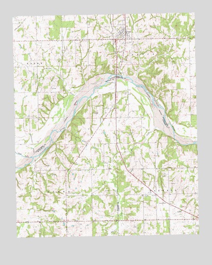
Asher, OK USGS Topographic Map
Click on map above to begin viewing in our Map Viewer.

This topographic map contains these locations and features:
Feature Name Type Latitude Longitude GNIS ID View Map
AsherPopulated PlaceN34.9895°W96.9236°1089729View Map
Asher Elementary SchoolSchoolN34.9896°W96.9225°1790550View Map
Asher Fire DepartmentBuildingN34.9889°W96.9267°2656895View Map
Asher High SchoolSchoolN34.9899°W96.9221°1803833View Map
Asher Oil FieldOilfieldN34.9776°W96.9206°1089730View Map
Asher Police DepartmentBuildingN34.9888°W96.9266°2757528View Map
Big CreekStreamN34.9295°W96.8917°1090104View Map
Cat CreekStreamN34.9656°W96.9256°1091033View Map
ChismPopulated PlaceN34.9129°W96.9370°1100294View Map
Chism CreekStreamN34.9601°W96.9167°1091316View Map
Cook CemeteryCemeteryN34.9470°W96.9358°1091621View Map
Galey ChurchChurchN34.8976°W96.9039°1093093View Map
Hargus FarmsLocaleN34.9214°W96.9689°2611292View Map
Hiway TabernacleChurchN34.8884°W96.8867°1093804View Map
Julian CreekStreamN34.9662°W96.9339°1094270View Map
North Rover Oil FieldOilfieldN34.9959°W96.9972°1096000View Map
Northeast Byars Oil FieldOilfieldN34.9323°W96.9867°1096017View Map
Pond CreekStreamN34.9204°W96.9881°1096821View Map
Rover Oil FieldOilfieldN34.9704°W96.9881°1097512View Map
Town of AsherCivilN34.9884°W96.9255°2411648View Map
West Asher Oil FieldOilfieldN34.9798°W96.9634°1099500View Map

Note: Coordinates in the location and feature list above are referenced to NAD83 datum.


Copyright (C) 2008-2025 Ryan Niemi / Sunset Dynamics ... All Rights Reserved