TopoQuest Logo
Do you find TopoQuest useful?
Help keep TopoQuest running and adding new maps/features by donating!
Bitcoin:  19c7KJd3qBynnjoSw5npx9KScwjBe4ifkT
Litecoin:  LXs6TkuXGGXo1vDsWCkWVdjQX94eUKd6ui
Home View Maps Find Maps Find Places Resources & Links


Peck Lake, New York Topographic Map

USGS Map Title: Peck Lake, NY
USGS Map MRC: 43074A4
DRG (GeoTIFF) Download: o43074a4.tif


Neighboring USGS Topographic Map Quads:


  Canada Lake, NY  
43074B5
 

  Caroga Lake, NY  
43074B4
 

  Jackson Summit, NY  
43074B3
 

  Lassellsville, NY  
43074A5
 

  Peck Lake, NY  
43074A4
 

  Gloversville, NY  
43074A3
 

  Canajoharie, NY  
42074H5
 

  Randall, NY  
42074H4
 

  Tribes Hill, NY  
42074H3


Map MRC Location:

N44°
W75°
N44°
W74°
H8 H7 H6 H5 H4 H3 H2 H1
G8 G7 G6 G5 G4 G3 G2 G1
F8 F7 F6 F5 F4 F3 F2 F1
E8 E7 E6 E5 E4 E3 E2 E1
D8 D7 D6 D5 D4 D3 D2 D1
C8 C7 C6 C5 C4 C3 C2 C1
B8 B7 B6 B5 B4 B3 B2 B1
A8 A7 A6 A5 A4 A3 A2 A1
N43°
W75°
N43°
W74°

Peck Lake, NY USGS 1:24K Topographic Map Preview:
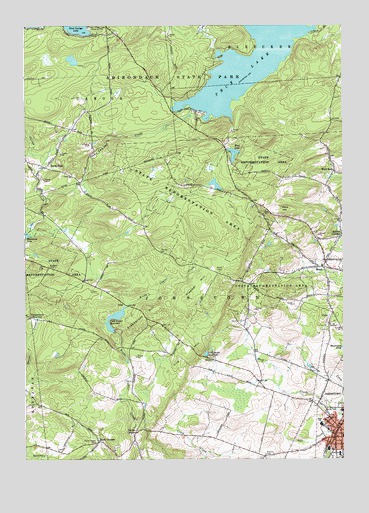
Peck Lake, NY USGS Topographic Map
Click on map above to begin viewing in our Map Viewer.

This topographic map contains these locations and features:
Feature Name Type Latitude Longitude GNIS ID View Map
Boshart CemeteryCemeteryN43.0012°W74.4060°944468View Map
Canajoharie ReservoirReservoirN43.0408°W74.4952°945738View Map
Church of the Immaculate ConceptionChurchN43.0081°W74.3792°2416760View Map
City of JohnstownCivilN43.0073°W74.3755°979110View Map
Clapper HillSummitN43.0473°W74.4349°946729View Map
Clip HillSummitN43.0326°W74.4312°946905View Map
Clip Hill School (historical)SchoolN43.0300°W74.4422°2123423View Map
Cold Brook ReservoirReservoirN43.0303°W74.4287°947047View Map
CorkPopulated PlaceN43.0448°W74.4607°972345View Map
Cork Center ReservoirReservoirN43.0414°W74.4646°947448View Map
Crossroads School (historical)SchoolN43.0064°W74.4258°2123424View Map
Deer Creek Mobile Home ParkPopulated PlaceN43.0477°W74.3878°2618215View Map
East Caroga Lake Camping AreaAreaN43.1234°W74.4715°949034View Map
Eppie CornersPopulated PlaceN43.0054°W74.4707°949677View Map
Erkenbrack HillSummitN43.0387°W74.4568°949691View Map
Faith TabernacleChurchN43.0078°W74.3800°2416759View Map
Fulton CountyCivilN43.1138°W74.4222°974116View Map
Glasgow CreekStreamN43.0881°W74.4965°951156View Map
Hall CreekStreamN43.0145°W74.3779°952051View Map
Johnstown HospitalHospitalN43.0019°W74.3764°2416754View Map
Johnstown Senior High SchoolSchoolN43.0100°W74.3836°2416767View Map
Kecks CenterPopulated PlaceN43.0079°W74.4565°954422View Map
Kecks Center CemeteryCemeteryN43.0047°W74.4721°954423View Map
Mathew CreekStreamN43.0098°W74.3765°956668View Map
McBeth CemeteryCemeteryN43.0556°W74.4902°956722View Map
MecoPopulated PlaceN43.0559°W74.3824°956899View Map
Meco Volunteer Fire DepartmentBuildingN43.0550°W74.3779°2735144View Map
Mud LakeLakeN43.0881°W74.4176°958027View Map
North BushPopulated PlaceN43.0848°W74.4924°958737View Map
North Bush Church (historical)ChurchN43.0814°W74.4817°2123422View Map
Peck CreekStreamN43.0756°W74.4907°960081View Map
Peck HillSummitN43.0723°W74.3999°960082View Map
Peck LakeReservoirN43.1145°W74.4115°970466View Map
Peck Lake (historical)SchoolN43.0950°W74.4317°2123425View Map
Pineview Commons Home for AdultsBuildingN43.0017°W74.3762°2614755View Map
Rhodes CemeteryCemeteryN43.0600°W74.4466°962442View Map
Rockwood LakeLakeN43.0657°W74.4998°962774View Map
Rogers Family OrchardsLocaleN43.0328°W74.4081°2556785View Map
Sampsonsville Volunteer Fire DepartmentBuildingN43.0053°W74.4246°2718601View Map
School Number 17 (historical)SchoolN43.0789°W74.3811°2123426View Map
Scotchbush School (historical)SchoolN43.0308°W74.4092°2123427View Map
Sir William Johnson State ParkParkN43.0140°W74.3787°965305View Map
Sir William Johnson Volunteer Fire DepartmentBuildingN43.0223°W74.4073°2735146View Map
Smiths CornersPopulated PlaceN43.0642°W74.3757°965530View Map
Town of JohnstownCivilN43.0457°W74.3958°979111View Map
Warren Street Elementary SchoolSchoolN43.0087°W74.3810°968820View Map
Wells HouseBuildingN43.0011°W74.3764°2416755View Map
Wells Nursing HomeBuildingN43.0011°W74.3761°2614839View Map
Wemple School (historical)SchoolN43.0192°W74.4708°2123428View Map
West BushPopulated PlaceN43.0831°W74.3782°969156View Map
Wheelerville Union Free SchoolSchoolN43.1234°W74.4993°2669132View Map
WSRD-FM (Johnstown)TowerN43.0540°W74.4237°977749View Map
Yost CreekStreamN43.0076°W74.3793°971842View Map

Note: Coordinates in the location and feature list above are referenced to NAD83 datum.


Copyright (C) 2008-2024 Ryan Niemi / Sunset Dynamics ... All Rights Reserved