TopoQuest Logo
Do you find TopoQuest useful?
Help keep TopoQuest running and adding new maps/features by donating!
Bitcoin:  19c7KJd3qBynnjoSw5npx9KScwjBe4ifkT
Litecoin:  LXs6TkuXGGXo1vDsWCkWVdjQX94eUKd6ui
Home View Maps Find Maps Find Places Resources & Links


Canada Lake, New York Topographic Map

USGS Map Title: Canada Lake, NY
USGS Map MRC: 43074B5
DRG (GeoTIFF) Download: o43074b5.tif


Neighboring USGS Topographic Map Quads:


  Stratford, NY  
43074B6
 

  Canada Lake, NY  
43074B5
 

  Caroga Lake, NY  
43074B4
 

  Oppenheim, NY  
43074A6
 

  Lassellsville, NY  
43074A5
 

  Peck Lake, NY  
43074A4


Map MRC Location:

N44°
W75°
N44°
W74°
H8 H7 H6 H5 H4 H3 H2 H1
G8 G7 G6 G5 G4 G3 G2 G1
F8 F7 F6 F5 F4 F3 F2 F1
E8 E7 E6 E5 E4 E3 E2 E1
D8 D7 D6 D5 D4 D3 D2 D1
C8 C7 C6 C5 C4 C3 C2 C1
B8 B7 B6 B5 B4 B3 B2 B1
A8 A7 A6 A5 A4 A3 A2 A1
N43°
W75°
N43°
W74°

Canada Lake, NY USGS 1:24K Topographic Map Preview:
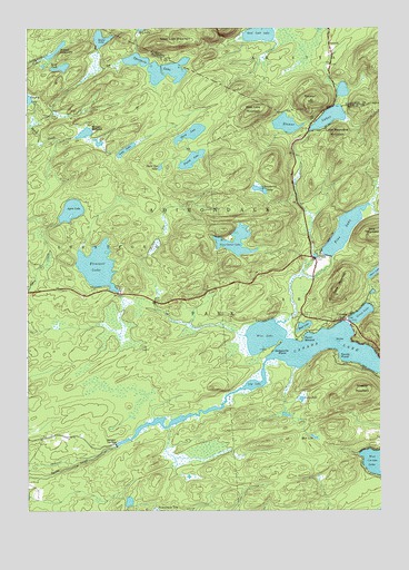
Canada Lake, NY USGS Topographic Map
Click on map above to begin viewing in our Map Viewer.

This topographic map contains these locations and features:
Feature Name Type Latitude Longitude GNIS ID View Map
AriettaPopulated PlaceN43.2462°W74.5176°942552View Map
Ayers LakeLakeN43.2030°W74.6090°942743View Map
Broomstick LakeLakeN43.2081°W74.5422°944896View Map
Burnt VlyValleyN43.1914°W74.5815°945275View Map
Canada LakeLakeN43.1651°W74.5311°945726View Map
Canada LakePopulated PlaceN43.1742°W74.5115°945727View Map
Dexter LakeLakeN43.2472°W74.5983°948395View Map
Dolgeville PointCapeN43.1667°W74.5385°948551View Map
Fourth LakeLakeN43.2159°W74.5663°950543View Map
Good Luck LakeLakeN43.2485°W74.5425°951308View Map
Good Luck MountainSummitN43.2462°W74.5774°951309View Map
Goose Egg LakeLakeN43.2138°W74.5775°951357View Map
Green LakeLakeN43.1758°W74.5066°951702View Map
Kane MountainsSummitN43.1809°W74.5154°954380View Map
Knapps Long LakeLakeN43.2431°W74.6163°954767View Map
Lily LakeSwampN43.1576°W74.5446°955315View Map
Little Roundtop MountainSummitN43.2226°W74.5149°955672View Map
Long LakeLakeN43.2185°W74.5899°955871View Map
Long PondLakeN43.2398°W74.6124°955912View Map
Mud LakeLakeN43.1727°W74.5270°958028View Map
Mud LakeSwampN43.1440°W74.5232°958041View Map
Negro LakeSwampN43.1540°W74.5279°958347View Map
Nine Corner LakeLakeN43.1946°W74.5509°958593View Map
Pine LakeReservoirN43.1973°W74.5127°960502View Map
Pine Lake Campground and Recreational Vehicle ParkLocaleN43.1910°W74.5158°2615228View Map
Pine Lake Mobile Home ParkPopulated PlaceN43.1885°W74.5193°2618267View Map
Pine MountainSummitN43.1962°W74.5021°970482View Map
Pleasant LakeLakeN43.1883°W74.5998°960711View Map
Point BreezeCapeN43.1692°W74.5282°960813View Map
Rooster HillSummitN43.2315°W74.5240°962883View Map
Sandy PointCapeN43.1653°W74.5174°964437View Map
Sheeley MountainSummitN43.1562°W74.5063°964993View Map
Southern Adirondack Pines Campground and CabinsLocaleN43.1928°W74.5206°2615238View Map
Spectacle LakeLakeN43.2397°W74.5797°965962View Map
Stewart LandingPopulated PlaceN43.1426°W74.5935°973116View Map
Stoner IslandIslandN43.1687°W74.5149°966520View Map
Stoner LakesLakeN43.2267°W74.5175°966521View Map
Third LakeLakeN43.2227°W74.5665°967369View Map
Town of CarogaCivilN43.1551°W74.5003°978794View Map
Waters MillpondLakeN43.2230°W74.6042°968911View Map
West LakeLakeN43.1701°W74.5410°970774View Map
West Lake MountainSummitN43.2290°W74.5446°970779View Map

Note: Coordinates in the location and feature list above are referenced to NAD83 datum.


Copyright (C) 2008-2024 Ryan Niemi / Sunset Dynamics ... All Rights Reserved