TopoQuest Logo
Do you find TopoQuest useful?
Help keep TopoQuest running and adding new maps/features by donating!
Bitcoin:  19c7KJd3qBynnjoSw5npx9KScwjBe4ifkT
Litecoin:  LXs6TkuXGGXo1vDsWCkWVdjQX94eUKd6ui
Home View Maps Find Maps Find Places Resources & Links


Aladdin Mountain, Washington Topographic Map

USGS Map Title: Aladdin Mountain, WA
USGS Map MRC: 48117F5
DRG (GeoTIFF) Download: o48117f5.tif


Neighboring USGS Topographic Map Quads:


  Spirit, WA  
48117G6
 

  Deep Lake, WA  
48117G5
 

  Metaline, WA  
48117G4
 

  Aladdin, WA  
48117F6
 

  Aladdin Mountain, WA  
48117F5
 

  Ione, WA  
48117F4
 

  Park Rapids, WA  
48117E6
 

  Lake Gillette, WA  
48117E5
 

  Timber Mountain, WA  
48117E4


Map MRC Location:

N49°
W118°
N49°
W117°
H8 H7 H6 H5 H4 H3 H2 H1
G8 G7 G6 G5 G4 G3 G2 G1
F8 F7 F6 F5 F4 F3 F2 F1
E8 E7 E6 E5 E4 E3 E2 E1
D8 D7 D6 D5 D4 D3 D2 D1
C8 C7 C6 C5 C4 C3 C2 C1
B8 B7 B6 B5 B4 B3 B2 B1
A8 A7 A6 A5 A4 A3 A2 A1
N48°
W118°
N48°
W117°

Aladdin Mountain, WA USGS 1:24K Topographic Map Preview:
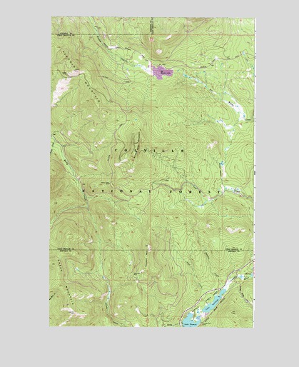
Aladdin Mountain, WA USGS Topographic Map
Click on map above to begin viewing in our Map Viewer.

This topographic map contains these locations and features:
Feature Name Type Latitude Longitude GNIS ID View Map
Aladdin MountainSummitN48.7282°W117.6105°1515770View Map
Big Meadow LakeReservoirN48.7278°W117.5577°1532370View Map
Big Meadow Lake CampgroundLocaleN48.7257°W117.5628°1988450View Map
Deer CreekStreamN48.6346°W117.5261°1518611View Map
Green MountainSummitN48.6502°W117.6214°1520315View Map
Heather Lake DamDamN48.7282°W117.5628°1532369View Map
Hills MeadowFlatN48.6316°W117.5694°1520810View Map
Lake HeritageLakeN48.6352°W117.5247°1520726View Map
Lasota MineMineN48.7266°W117.6153°1515702View Map
Little Pend Oreille LakesLakeN48.6296°W117.5325°1522284View Map
Middleport MineMineN48.6469°W117.5686°1523109View Map
Patchen CreekStreamN48.6405°W117.5186°1524244View Map
Polley CreekStreamN48.7007°W117.6222°1524560View Map
Princess Pine CampLocaleN48.6274°W117.5319°1524650View Map
Rocky Creek MineMineN48.6824°W117.5886°1525168View Map
Seldom Seen MountainSummitN48.6991°W117.5716°1525568View Map
Stewart MeadowFlatN48.6902°W117.5191°1526557View Map
Thomas MountainSummitN48.6485°W117.5655°1527101View Map

Note: Coordinates in the location and feature list above are referenced to NAD83 datum.


Copyright (C) 2008-2024 Ryan Niemi / Sunset Dynamics ... All Rights Reserved