TopoQuest Logo
Do you find TopoQuest useful?
Help keep TopoQuest running and adding new maps/features by donating!
Bitcoin:  19c7KJd3qBynnjoSw5npx9KScwjBe4ifkT
Litecoin:  LXs6TkuXGGXo1vDsWCkWVdjQX94eUKd6ui
Home View Maps Find Maps Find Places Resources & Links


Bernstadt, Kentucky Topographic Map

USGS Map Title: Bernstadt, KY
USGS Map MRC: 37084B2
DRG (GeoTIFF) Download: o37084b2.tif


Neighboring USGS Topographic Map Quads:


  Mount Vernon, KY  
37084C3
 

  Livingston, KY  
37084C2
 

  Parrot, KY  
37084C1
 

  Billows, KY  
37084B3
 

  Bernstadt, KY  
37084B2
 

  London, KY  
37084B1
 

  Ano, KY  
37084A3
 

  London SW, KY  
37084A2
 

  Lily, KY  
37084A1


Map MRC Location:

N38°
W85°
N38°
W84°
H8 H7 H6 H5 H4 H3 H2 H1
G8 G7 G6 G5 G4 G3 G2 G1
F8 F7 F6 F5 F4 F3 F2 F1
E8 E7 E6 E5 E4 E3 E2 E1
D8 D7 D6 D5 D4 D3 D2 D1
C8 C7 C6 C5 C4 C3 C2 C1
B8 B7 B6 B5 B4 B3 B2 B1
A8 A7 A6 A5 A4 A3 A2 A1
N37°
W85°
N37°
W84°

Bernstadt, KY USGS 1:24K Topographic Map Preview:
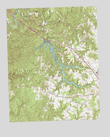
Bernstadt, KY USGS Topographic Map
Click on map above to begin viewing in our Map Viewer.

This topographic map contains these locations and features:
Feature Name Type Latitude Longitude GNIS ID View Map
Altamont CreekStreamN37.2351°W84.1727°510250View Map
Andes CemeteryCemeteryN37.2254°W84.1302°510268View Map
Arthur RidgeRidgeN37.2312°W84.1444°510305View Map
Begley HollowValleyN37.2480°W84.1972°510534View Map
BernstadtPopulated PlaceN37.1562°W84.1947°510562View Map
Big BranchStreamN37.2126°W84.1980°510616View Map
Billy BranchStreamN37.1695°W84.1735°510725View Map
Bulls BranchStreamN37.2120°W84.1394°511056View Map
Carmichael Community Pentecostal ChurchChurchN37.1873°W84.1391°511218View Map
Colony DivisionCivilN37.1541°W84.2166°1936941View Map
Colony Elementary SchoolSchoolN37.1545°W84.1874°517520View Map
Daniel Boone Motocross ParkLocaleN37.1547°W84.1873°2723127View Map
East Bernstadt DivisionCivilN37.2412°W84.1365°1936982View Map
East Bernstadt Fire DepartmentBuildingN37.1736°W84.1262°2636462View Map
Faulkners Railroad Station (historical)LocaleN37.2286°W84.1616°2723161View Map
GG HeliportAirportN37.1793°W84.1288°517420View Map
Gillis BranchStreamN37.1859°W84.1752°512314View Map
Happy HollowValleyN37.2406°W84.2003°512557View Map
HarePopulated PlaceN37.2044°W84.1569°2093821View Map
Hawk Creek ChurchChurchN37.1851°W84.1980°512601View Map
Hazel PatchPopulated PlaceN37.2445°W84.1930°512622View Map
Hazel Patch CreekStreamN37.2320°W84.1999°512623View Map
Hazel Patch Post Office (historical)Post OfficeN37.2334°W84.1963°2723397View Map
Hellard BranchStreamN37.2426°W84.1619°512639View Map
Hog BranchStreamN37.2365°W84.1694°512724View Map
Johnson RidgeRidgeN37.2098°W84.1519°513054View Map
Johnson Ridge SchoolSchoolN37.2040°W84.1572°495423View Map
Jones ForkStreamN37.1856°W84.1724°513070View Map
King HollowValleyN37.2240°W84.1549°513152View Map
Lake View ChurchChurchN37.1965°W84.1569°513190View Map
Laurel BranchStreamN37.2179°W84.1941°513221View Map
Laurel BranchStreamN37.2409°W84.1480°513233View Map
Liberty Baptist ChurchChurchN37.1523°W84.1369°513372View Map
Little Hazel Patch CreekStreamN37.2354°W84.1283°513489View Map
Little Rockcastle RiverStreamN37.2423°W84.2174°513518View Map
Long BranchStreamN37.2409°W84.2388°513605View Map
Milburn HollowValleyN37.2482°W84.2199°513959View Map
Mount Moriah ChurchChurchN37.1743°W84.1858°514094View Map
Old Dog PatchLocaleN37.1734°W84.1267°2723193View Map
Philpot HollowValleyN37.2234°W84.1530°514535View Map
Pine Top ChurchChurchN37.1256°W84.1472°514602View Map
Rockcastle River BridgeBridgeN37.2408°W84.2200°2723317View Map
Rocky BranchStreamN37.2054°W84.1888°515056View Map
Saint Johns ChurchChurchN37.1818°W84.1299°515176View Map
Shetland CreekStreamN37.2401°W84.2002°515351View Map
Snuffer CemeteryCemeteryN37.1884°W84.1460°515529View Map
Stillhouse BranchStreamN37.2220°W84.1483°515707View Map
Swiss Colony Volunteer Fire DepartmentBuildingN37.1538°W84.1864°2636834View Map
Swiss Colony Volunteer Fire Department Station 2BuildingN37.1369°W84.1379°2637439View Map
Tunnel Number 6TunnelN37.2454°W84.2083°517298View Map
Tunnel Number 7TunnelN37.2348°W84.1769°517299View Map
Tunnel Number 8TunnelN37.2312°W84.1649°517300View Map
Tunnel Number 9TunnelN37.2137°W84.1380°517301View Map
Upper Colony ChurchChurchN37.1495°W84.1705°516116View Map
Warrens Grove ChurchChurchN37.1423°W84.1466°516235View Map
Whitt CemeteryCemeteryN37.1854°W84.2152°516344View Map
Wollum BranchStreamN37.2256°W84.1988°516465View Map
Wood CreekStreamN37.2320°W84.1994°516466View Map
Wood Creek LakeReservoirN37.1895°W84.1812°516467View Map

Note: Coordinates in the location and feature list above are referenced to NAD83 datum.


Copyright (C) 2008-2025 Ryan Niemi / Sunset Dynamics ... All Rights Reserved