TopoQuest Logo
Do you find TopoQuest useful?
Help keep TopoQuest running and adding new maps/features by donating!
Bitcoin:  19c7KJd3qBynnjoSw5npx9KScwjBe4ifkT
Litecoin:  LXs6TkuXGGXo1vDsWCkWVdjQX94eUKd6ui
Home View Maps Find Maps Find Places Resources & Links


Mount Vernon, Kentucky Topographic Map

USGS Map Title: Mount Vernon, KY
USGS Map MRC: 37084C3
DRG (GeoTIFF) Download: o37084c3.tif


Neighboring USGS Topographic Map Quads:


  Brodhead, KY  
37084D4
 

  Wildie, KY  
37084D3
 

  Johnetta, KY  
37084D2
 

  Maretburg, KY  
37084C4
 

  Mount Vernon, KY  
37084C3
 

  Livingston, KY  
37084C2
 

  Shopville, KY  
37084B4
 

  Billows, KY  
37084B3
 

  Bernstadt, KY  
37084B2


Map MRC Location:

N38°
W85°
N38°
W84°
H8 H7 H6 H5 H4 H3 H2 H1
G8 G7 G6 G5 G4 G3 G2 G1
F8 F7 F6 F5 F4 F3 F2 F1
E8 E7 E6 E5 E4 E3 E2 E1
D8 D7 D6 D5 D4 D3 D2 D1
C8 C7 C6 C5 C4 C3 C2 C1
B8 B7 B6 B5 B4 B3 B2 B1
A8 A7 A6 A5 A4 A3 A2 A1
N37°
W85°
N37°
W84°

Mount Vernon, KY USGS 1:24K Topographic Map Preview:
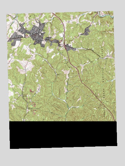
Mount Vernon, KY USGS Topographic Map
Click on map above to begin viewing in our Map Viewer.

This topographic map contains these locations and features:
Feature Name Type Latitude Longitude GNIS ID View Map
Bible ChurchChurchN37.3390°W84.2958°510588View Map
Blue SpringsSpringN37.2704°W84.3599°510806View Map
Blue Springs SchoolSchoolN37.2690°W84.3591°510807View Map
Brush Creek Railroad Station (historical)LocaleN37.3723°W84.2686°2726004View Map
BurrPopulated PlaceN37.3420°W84.3049°511088View Map
Chestnut Ridge ChurchChurchN37.3451°W84.3147°511338View Map
City of Mount VernonCivilN37.3578°W84.3432°2404325View Map
Cook Railroad Stop (historical)LocaleN37.3524°W84.3094°2726009View Map
Cove BranchStreamN37.3723°W84.2785°511580View Map
Dry ForkStreamN37.2579°W84.3610°511923View Map
Elmwood CemeteryCemeteryN37.3534°W84.3363°512057View Map
Flat RockPopulated PlaceN37.3609°W84.2710°512196View Map
HansfordPopulated PlaceN37.2698°W84.3699°512550View Map
Lime Plant HollowValleyN37.3301°W84.2670°513425View Map
Lover CemeteryCemeteryN37.3404°W84.2952°513655View Map
Maple Grove ChurchChurchN37.3465°W84.2988°513775View Map
Maple Grove SchoolSchoolN37.3623°W84.2663°513777View Map
Marlow HollowValleyN37.2900°W84.3529°513794View Map
McKinney CemeteryCemeteryN37.2598°W84.3622°513877View Map
Mount VernonPopulated PlaceN37.3529°W84.3405°514113View Map
Mount Vernon Police DepartmentBuildingN37.3564°W84.3402°2767572View Map
Mount Vernon Volunteer Fire DepartmentBuildingN37.3547°W84.3403°2636666View Map
OrlandoPopulated PlaceN37.3729°W84.2680°514376View Map
Owens Station (historical)LocaleN37.3420°W84.3046°2726030View Map
Penick HollowValleyN37.2522°W84.3656°514483View Map
Pine HillPopulated PlaceN37.3295°W84.2633°514583View Map
Pine Hill Railroad Station (historical)LocaleN37.3314°W84.2605°2726032View Map
Pitman BranchStreamN37.2840°W84.3047°514626View Map
Price BranchStreamN37.2851°W84.3535°514766View Map
Rash BranchStreamN37.2904°W84.3094°514839View Map
Rockcastle CountyCivilN37.3652°W84.3159°516948View Map
Rockcastle County Ambulance ServiceBuildingN37.3586°W84.3371°2719142View Map
Rockcastle County Sheriff's OfficeBuildingN37.3526°W84.3383°2767791View Map
Rockcastle Regional HospitalHospitalN37.3571°W84.3364°2660353View Map
Sand SpringsPopulated PlaceN37.2970°W84.3591°515230View Map
Sites BranchStreamN37.2645°W84.3022°515444View Map
Sparks Quarry Station (historical)LocaleN37.3422°W84.3065°2726041View Map
Sparks Vocational SchoolSchoolN37.3579°W84.3574°515575View Map
The Central ChurchChurchN37.3465°W84.3244°515907View Map
WellhopePopulated PlaceN37.3162°W84.3183°516264View Map
Wellhope ChurchChurchN37.2943°W84.3163°516265View Map
Wellhope SchoolSchoolN37.2929°W84.3072°516266View Map
West Fork Skegg CreekStreamN37.2579°W84.3610°516276View Map

Note: Coordinates in the location and feature list above are referenced to NAD83 datum.


Copyright (C) 2008-2024 Ryan Niemi / Sunset Dynamics ... All Rights Reserved