TopoQuest Logo
Do you find TopoQuest useful?
Help keep TopoQuest running and adding new maps/features by donating!
Bitcoin:  19c7KJd3qBynnjoSw5npx9KScwjBe4ifkT
Litecoin:  LXs6TkuXGGXo1vDsWCkWVdjQX94eUKd6ui
Home View Maps Find Maps Find Places Resources & Links


Penhook, Virginia Topographic Map

USGS Map Title: Penhook, VA
USGS Map MRC: 36079H6
DRG (GeoTIFF) Download: o36079h6.tif


Neighboring USGS Topographic Map Quads:


  Redwood, VA  
37079A7
 

  Moneta SW, VA  
37079A6
 

  Smith Mountain Dam, VA  
37079A5
 

  Gladehill, VA  
36079H7
 

  Penhook, VA  
36079H6
 

  Sandy Level, VA  
36079H5
 

  Snow Creek, VA  
36079G7
 

  Mountain Valley, VA  
36079G6
 

  Callands, VA  
36079G5


Map MRC Location:

N37°
W80°
N37°
W79°
H8 H7 H6 H5 H4 H3 H2 H1
G8 G7 G6 G5 G4 G3 G2 G1
F8 F7 F6 F5 F4 F3 F2 F1
E8 E7 E6 E5 E4 E3 E2 E1
D8 D7 D6 D5 D4 D3 D2 D1
C8 C7 C6 C5 C4 C3 C2 C1
B8 B7 B6 B5 B4 B3 B2 B1
A8 A7 A6 A5 A4 A3 A2 A1
N36°
W80°
N36°
W79°

Penhook, VA USGS 1:24K Topographic Map Preview:
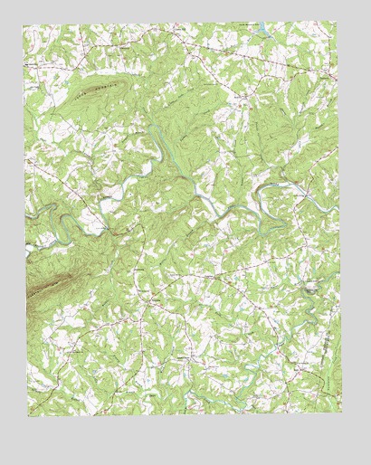
Penhook, VA USGS Topographic Map
Click on map above to begin viewing in our Map Viewer.

This topographic map contains these locations and features:
Feature Name Type Latitude Longitude GNIS ID View Map
Adams CemeteryCemeteryN36.8876°W79.6856°1791479View Map
Adams StoreLocaleN36.8924°W79.6848°1462366View Map
Adkins CemeteryCemeteryN36.9332°W79.6270°1791480View Map
Allman CemeteryCemeteryN36.9860°W79.7442°1791483View Map
Allman CemeteryCemeteryN36.9668°W79.7161°1791484View Map
Amos CemeteryCemeteryN36.9137°W79.6464°1791487View Map
Amos-Smith CemeteryCemeteryN36.9176°W79.6384°1791488View Map
Arrington CemeteryCemeteryN36.9899°W79.7109°1791489View Map
Arthur CemeteryCemeteryN36.9737°W79.6650°1791491View Map
Belcher CemeteryCemeteryN36.8896°W79.6778°1463014View Map
Big Chestnut CreekStreamN36.9310°W79.7370°1463338View Map
Blankenship CemeteryCemeteryN36.9326°W79.6397°1791495View Map
Bradner-Toller CemeteryCemeteryN36.9707°W79.6347°1791499View Map
Brown CemeteryCemeteryN36.9307°W79.6384°1791503View Map
Brown-Kelly CemeteryCemeteryN36.9924°W79.6717°1791506View Map
Burell CemeteryCemeteryN36.8812°W79.6395°1791509View Map
Byrd CemeteryCemeteryN36.9882°W79.7417°1791510View Map
Carter CemeteryCemeteryN36.9718°W79.6653°1791511View Map
Chapel CemeteryCemeteryN36.9190°W79.6622°1791512View Map
Cleveland School (historical)SchoolN36.8976°W79.7303°1494407View Map
Cool Spring ChurchChurchN36.8907°W79.6425°1465201View Map
Cool Springs CemeteryCemeteryN36.8910°W79.6434°1791515View Map
Crossroads School (historical)SchoolN36.9060°W79.6845°1494415View Map
Cundiff CemeteryCemeteryN36.9685°W79.6697°1791517View Map
David CemeteryCemeteryN36.9479°W79.6756°1791518View Map
DickinsonPopulated PlaceN36.9204°W79.7070°1477263View Map
Dickinson School (historical)SchoolN36.9393°W79.7061°1494417View Map
Dinner CreekStreamN36.9415°W79.6648°1465812View Map
Ditto BranchStreamN36.8774°W79.6873°1465827View Map
Doss CemeteryCemeteryN36.9862°W79.6286°1791522View Map
Duffy BranchStreamN36.8807°W79.7028°1466031View Map
Edwards CemeteryCemeteryN36.9896°W79.7161°1791527View Map
Edwards CemeteryCemeteryN36.9724°W79.6661°1791528View Map
Edwards FordCrossingN36.9424°W79.6561°1494423View Map
Ellis CemeteryCemeteryN36.9976°W79.6964°1791529View Map
Ephesus ChurchChurchN36.9918°W79.7106°1466326View Map
Ferguson-Edwards CemeteryCemeteryN36.9871°W79.7356°1791532View Map
Finney BranchStreamN36.8796°W79.6964°1466564View Map
First ForkStreamN36.8968°W79.6514°1466584View Map
Forest Hill CemeteryCemeteryN36.9190°W79.6886°1791533View Map
Forrest Hill ChurchChurchN36.9193°W79.6875°1466789View Map
Fralin BridgeBridgeN36.9340°W79.7167°1466843View Map
Fralin CemeteryCemeteryN36.9424°W79.6981°1791534View Map
Fralin CemeteryCemeteryN36.9971°W79.7070°1791535View Map
Franklin Grove ChurchChurchN36.9168°W79.6386°1466852View Map
Glade CreekStreamN36.9488°W79.7106°1467117View Map
Glade Hill Elementary SchoolSchoolN36.9875°W79.7489°1467122View Map
Gourd CreekStreamN36.8771°W79.6628°1467297View Map
Gregory CemeteryCemeteryN36.9054°W79.7111°1791539View Map
Gregory CemeteryCemeteryN36.8760°W79.6470°1791540View Map
Gregory CemeteryCemeteryN36.9007°W79.6411°1791542View Map
Haines BridgeBridgeN36.9443°W79.6378°1467635View Map
Housman-Ferguson CemeteryCemeteryN36.9971°W79.7156°1791560View Map
Hundley-Beckner CemeteryCemeteryN36.9007°W79.7220°1791561View Map
Hutchinson CemeteryCemeteryN36.9574°W79.7475°1791566View Map
Jacks CreekStreamN36.9676°W79.6973°1468580View Map
Jacks MountainSummitN36.9779°W79.7217°1468587View Map
Jacks Mountain QuarryMineN36.9756°W79.7117°2724877View Map
Jefferson CemeteryCemeteryN36.9049°W79.7050°1791571View Map
Kemp-David CemeteryCemeteryN36.9818°W79.6525°1791573View Map
King CemeteryCemeteryN36.9757°W79.6300°1791574View Map
Kirk CemeteryCemeteryN36.9226°W79.6539°1469036View Map
Laprade CemeteryCemeteryN36.9149°W79.6342°1791575View Map
Laprades MillPopulated PlaceN36.9138°W79.6350°1496976View Map
Law CemeteryCemeteryN36.8974°W79.7311°1791576View Map
Law CemeteryCemeteryN36.8924°W79.6431°1791577View Map
Law CemeteryCemeteryN36.9207°W79.7081°1791578View Map
Little Jacks CreekStreamN36.9688°W79.6981°1469576View Map
Matley CemeteryCemeteryN36.9043°W79.7184°1791589View Map
Mattox CemeteryCemeteryN36.9932°W79.7253°1791590View Map
Mayflower School (historical)SchoolN36.9271°W79.6425°1494459View Map
Millie BranchStreamN36.9382°W79.6731°1470573View Map
Moore-Dudley CemeteryCemeteryN36.9587°W79.6684°1791597View Map
Mount Carmel CemeteryCemeteryN36.8957°W79.7317°1791599View Map
Mount Carmel ChurchChurchN36.8951°W79.7317°1470844View Map
Mountain Grove School (historical)SchoolN36.9654°W79.7181°1494466View Map
Muse CemeteryCemeteryN36.8893°W79.6403°1791601View Map
Neville-Horsley CemeteryCemeteryN36.9735°W79.6606°1791602View Map
New Design ChurchChurchN36.9796°W79.7428°1471409View Map
Northfield CemeteryCemeteryN36.9801°W79.6722°1471660View Map
Northfield Church (historical)ChurchN36.9801°W79.6728°1494473View Map
Old Glade Hill School (historical)SchoolN36.9538°W79.7425°1494475View Map
Owens CreekStreamN36.9479°W79.6442°1471993View Map
Palmer CemeteryCemeteryN36.9076°W79.6509°1791604View Map
Parrot BranchStreamN36.9479°W79.6442°1472079View Map
Pearson FordCrossingN36.9413°W79.6650°1494478View Map
Peckerwood LevelPopulated PlaceN36.9285°W79.6381°1494479View Map
Pelter CemeteryCemeteryN36.9949°W79.7397°1791608View Map
PenhookPopulated PlaceN36.9824°W79.6281°1497083View Map
Penhook Census Designated PlaceCensusN36.9904°W79.6318°2389656View Map
Penhook Post OfficePost OfficeN36.9819°W79.6277°2766267View Map
Penhook School (historical)SchoolN36.9882°W79.6281°1494481View Map
Perdue CemeteryCemeteryN36.9943°W79.6659°1791609View Map
Polecat CreekStreamN36.9532°W79.6467°1472583View Map
Poplar BranchStreamN36.9176°W79.6298°1472634View Map
Potter CemeteryCemeteryN36.9224°W79.6739°1791611View Map
ProgressPopulated PlaceN36.9179°W79.6753°1477647View Map
SagoPopulated PlaceN36.8888°W79.6411°1477710View Map
Strawfield CreekStreamN36.9665°W79.6423°1475244View Map
Tanyard BranchStreamN36.9651°W79.6995°1475462View Map
TruevineLocaleN36.9107°W79.7009°1475899View Map
Truevine CemeteryCemeteryN36.9107°W79.7017°1791639View Map
Truevine ChurchChurchN36.9107°W79.7025°1791640View Map
Truevine SchoolSchoolN36.9146°W79.7048°1475900View Map
Turkey CreekStreamN36.9565°W79.6898°1475940View Map
Union HallLocaleN36.9965°W79.6889°1476070View Map
Union Hall Post OfficePost OfficeN36.9978°W79.6909°2766312View Map
Union Hall School (historical)SchoolN36.9907°W79.6825°1494526View Map
Walker CreekStreamN36.9340°W79.7170°1476236View Map
Ward BranchStreamN36.8813°W79.6931°1476309View Map
Wilson-Cook CemeteryCemeteryN36.9551°W79.7461°1791654View Map
Wright CemeteryCemeteryN36.9885°W79.6814°1791656View Map
Young CemeteryCemeteryN36.9290°W79.6384°1791658View Map
Zeigler CemeteryCemeteryN36.9399°W79.7153°1791661View Map
Zeigler School (historical)SchoolN36.9538°W79.6689°1494532View Map
Ziegler FordCrossingN36.9513°W79.7039°1497143View Map

Note: Coordinates in the location and feature list above are referenced to NAD83 datum.


Copyright (C) 2008-2025 Ryan Niemi / Sunset Dynamics ... All Rights Reserved