TopoQuest Logo
Do you find TopoQuest useful?
Help keep TopoQuest running and adding new maps/features by donating!
Bitcoin:  19c7KJd3qBynnjoSw5npx9KScwjBe4ifkT
Litecoin:  LXs6TkuXGGXo1vDsWCkWVdjQX94eUKd6ui
Home View Maps Find Maps Find Places Resources & Links


Moneta SW, Virginia Topographic Map

USGS Map Title: Moneta SW, VA
USGS Map MRC: 37079A6
DRG (GeoTIFF) Download: o37079a6.tif


Neighboring USGS Topographic Map Quads:


  Hardy, VA  
37079B7
 

  Goodview, VA  
37079B6
 

  Moneta, VA  
37079B5
 

  Redwood, VA  
37079A7
 

  Moneta SW, VA  
37079A6
 

  Smith Mountain Dam, VA  
37079A5
 

  Gladehill, VA  
36079H7
 

  Penhook, VA  
36079H6
 

  Sandy Level, VA  
36079H5


Map MRC Location:

N38°
W80°
N38°
W79°
H8 H7 H6 H5 H4 H3 H2 H1
G8 G7 G6 G5 G4 G3 G2 G1
F8 F7 F6 F5 F4 F3 F2 F1
E8 E7 E6 E5 E4 E3 E2 E1
D8 D7 D6 D5 D4 D3 D2 D1
C8 C7 C6 C5 C4 C3 C2 C1
B8 B7 B6 B5 B4 B3 B2 B1
A8 A7 A6 A5 A4 A3 A2 A1
N37°
W80°
N37°
W79°

Moneta SW, VA USGS 1:24K Topographic Map Preview:
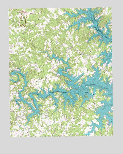
Moneta SW, VA USGS Topographic Map
Click on map above to begin viewing in our Map Viewer.

This topographic map contains these locations and features:
Feature Name Type Latitude Longitude GNIS ID View Map
ArrowheadPopulated PlaceN37.0132°W79.6317°1494381View Map
Beckys CreekStreamN37.1149°W79.6528°1462986View Map
Berger CemeteryCemeteryN37.0171°W79.6725°1494385View Map
Bernard CemeteryCemeteryN37.0057°W79.7017°1494386View Map
Bernard CemeteryCemeteryN37.0224°W79.7050°1791035View Map
Bernard DamDamN37.0068°W79.6964°1489817View Map
Bettys CreekStreamN37.1190°W79.6545°1463258View Map
Blankenship CemeteryCemeteryN37.0546°W79.7378°1791146View Map
Board-Robertson CemeteryCemeteryN37.1249°W79.7414°1791148View Map
Booker T Washington National MonumentParkN37.1152°W79.7319°1477005View Map
Brammer Seaplane BaseAirportN37.0335°W79.6998°1498827View Map
Breezy PointCapeN37.0999°W79.6423°1463787View Map
Brooks CemeteryCemeteryN37.0254°W79.7047°1791042View Map
Brown CemeteryCemeteryN37.0524°W79.6853°1791043View Map
Brown CemeteryCemeteryN37.0704°W79.7067°1791150View Map
Brown CemeteryCemeteryN37.0629°W79.7209°1791151View Map
Brown CemeteryCemeteryN37.0926°W79.7292°1791152View Map
Bull RunStreamN37.0332°W79.6250°1464071View Map
Burroughs CemeteryCemeteryN37.1204°W79.7317°1791154View Map
Carter-Foster CemeteryCemeteryN37.0568°W79.7059°1791047View Map
Crafts CemeteryCemeteryN37.0426°W79.7431°1791155View Map
Crafts ChurchChurchN37.0426°W79.7425°1465393View Map
Crafts FordCrossingN37.0432°W79.7359°1494793View Map
Crafts PointPopulated PlaceN37.0579°W79.7345°1494412View Map
Crazy Horse CampgroundLocaleN37.0438°W79.6373°1494413View Map
Cundiff CemeteryCemeteryN37.0135°W79.6792°1791056View Map
David CemeteryCemeteryN37.0204°W79.6622°1791057View Map
David CemeteryCemeteryN37.0201°W79.6861°1791058View Map
Davis CemeteryCemeteryN37.0049°W79.7106°1791156View Map
Dillon CemeteryCemeteryN37.0110°W79.6800°1791061View Map
Dillon CemeteryCemeteryN37.0901°W79.6981°1791157View Map
Dillon-English CemeteryCemeteryN37.0790°W79.7236°1791158View Map
Dudley CemeteryCemeteryN37.0349°W79.6636°1494421View Map
Dudley CemeteryCemeteryN37.0601°W79.6667°1791064View Map
Duncan CemeteryCemeteryN37.1199°W79.7125°1791159View Map
Durham CemeteryCemeteryN37.0837°W79.7167°1791160View Map
English CemeteryCemeteryN37.0246°W79.6775°1494425View Map
English CemeteryCemeteryN37.0651°W79.6781°1791162View Map
FoxsportPopulated PlaceN37.0554°W79.6775°1494433View Map
Gills CreekStreamN37.0471°W79.6659°1467100View Map
Gills Creek DistrictCivilN37.1146°W79.7215°1927328View Map
Greers FordCrossingN37.0951°W79.6317°1674847View Map
Haleford ChurchChurchN37.1215°W79.7378°1467650View Map
Halesford CemeteryCemeteryN37.1110°W79.6834°1791168View Map
Halesford CemeteryCemeteryN37.1215°W79.7384°1791169View Map
Halesford United Methodist ChurchChurchN37.1110°W79.6836°1791170View Map
Hancock CemeteryCemeteryN37.0024°W79.6409°1791075View Map
Holland CemeteryCemeteryN37.0201°W79.7395°1791171View Map
Holland CemeteryCemeteryN37.1101°W79.7264°1791172View Map
Holland-Mitchell CemeteryCemeteryN37.0574°W79.7478°1791173View Map
Holland-Powell CemeteryCemeteryN37.0279°W79.7320°1791174View Map
Holley CemeteryCemeteryN37.1037°W79.7228°1791175View Map
Holleys Mill (historical)LocaleN37.0829°W79.7039°1494797View Map
Housman CemeteryCemeteryN37.0237°W79.7147°1791176View Map
Hutchinsons Mill (historical)LocaleN37.0640°W79.6834°1494798View Map
Indian Ridge CemeteryCemeteryN37.0596°W79.6256°1791082View Map
Indian Ridge ChurchChurchN37.0596°W79.6253°1468482View Map
Isle of PinesPopulated PlaceN37.1079°W79.6356°1674856View Map
Jones CemeteryCemeteryN37.0818°W79.7470°1494451View Map
Jones CemeteryCemeteryN37.0710°W79.6686°1791179View Map
Kesler CemeteryCemeteryN37.0151°W79.7022°1791089View Map
Little Bull RunStreamN37.0224°W79.6342°1469489View Map
Lumsden CemeteryCemeteryN37.0365°W79.7245°1791180View Map
Maxey CemeteryCemeteryN37.0335°W79.6872°1791093View Map
Mount Ivy ChurchesChurchN37.0793°W79.6550°1470915View Map
Mount Zion ChurchChurchN37.0007°W79.6331°1471124View Map
Newbill CemeteryCemeteryN37.0076°W79.6528°1791103View Map
North ShorePopulated PlaceN37.0821°W79.6584°1852917View Map
North Shore Census Designated PlaceCensusN37.0778°W79.6518°2389583View Map
Old Bethel CemeteryCemeteryN37.0196°W79.7403°1791187View Map
Old Bethel ChurchChurchN37.0193°W79.7403°1471823View Map
Pasley CemeteryCemeteryN37.0835°W79.6867°1494477View Map
Pelican PointPopulated PlaceN37.0374°W79.6317°1494480View Map
Penhook State Boat RampParkN37.0135°W79.6256°1494482View Map
Perdue CemeteryCemeteryN37.0143°W79.7192°1791189View Map
Perdue CemeteryCemeteryN37.0512°W79.7247°1791190View Map
Perdue-Robertson CemeteryCemeteryN37.1046°W79.7492°1791191View Map
Poindexter CemeteryCemeteryN37.0421°W79.7036°1791114View Map
Poindexter-Saunders CemeteryCemeteryN37.0299°W79.6389°1791115View Map
Poplar Camp CreekStreamN37.0357°W79.7361°1472638View Map
Radfords FordCrossingN37.1101°W79.6439°1674891View Map
Robertson CemeteryCemeteryN37.0076°W79.6867°1791125View Map
ScruggsPopulated PlaceN37.0799°W79.6617°1496191View Map
Scruggs Volunteer Fire Department and Rescue Squad Company 10BuildingN37.0789°W79.6621°2086260View Map
Smith CemeteryCemeteryN37.0476°W79.7147°1791200View Map
Smiths ParadisePopulated PlaceN37.0282°W79.7248°1494513View Map
Southall-Brown CemeteryCemeteryN37.0724°W79.7245°1791201View Map
Standiford CreekStreamN37.0413°W79.6984°1475064View Map
The WaterfrontPopulated PlaceN37.1057°W79.6548°1494522View Map
Turner-Hutchenson CemeteryCemeteryN37.0726°W79.6700°1791204View Map
Union HallPopulated PlaceN37.0188°W79.6864°1852918View Map
Union Hall Census Designated PlaceCensusN37.0205°W79.6833°2390416View Map
Union Hall ChurchChurchN37.0054°W79.6839°1476072View Map
Union Hall DistrictCivilN37.0128°W79.7282°1927544View Map
Westlake CornerPopulated PlaceN37.1232°W79.6995°1852920View Map
Westlake Corner Census Designated PlaceCensusN37.1234°W79.6971°2390495View Map
White PinePopulated PlaceN37.0604°W79.6764°1494530View Map
Wilson CemeteryCemeteryN37.0837°W79.6650°1791142View Map
Witcher CemeteryCemeteryN37.1154°W79.6645°1791143View Map

Note: Coordinates in the location and feature list above are referenced to NAD83 datum.


Copyright (C) 2008-2024 Ryan Niemi / Sunset Dynamics ... All Rights Reserved