TopoQuest Logo
Do you find TopoQuest useful?
Help keep TopoQuest running and adding new maps/features by donating!
Bitcoin:  19c7KJd3qBynnjoSw5npx9KScwjBe4ifkT
Litecoin:  LXs6TkuXGGXo1vDsWCkWVdjQX94eUKd6ui
Home View Maps Find Maps Find Places Resources & Links


Berry Creek, California Topographic Map

USGS Map Title: Berry Creek, CA
USGS Map MRC: 39121F4
DRG (GeoTIFF) Download: o39121f4.tif


Neighboring USGS Topographic Map Quads:


  Paradise East, CA  
39121G5
 

  Pulga, CA  
39121G4
 

  Soapstone Hill, CA  
39121G3
 

  Cherokee, CA  
39121F5
 

  Berry Creek, CA  
39121F4
 

  Brush Creek, CA  
39121F3
 

  Oroville, CA  
39121E5
 

  Oroville Dam, CA  
39121E4
 

  Forbestown, CA  
39121E3


Map MRC Location:

N40°
W122°
N40°
W121°
H8 H7 H6 H5 H4 H3 H2 H1
G8 G7 G6 G5 G4 G3 G2 G1
F8 F7 F6 F5 F4 F3 F2 F1
E8 E7 E6 E5 E4 E3 E2 E1
D8 D7 D6 D5 D4 D3 D2 D1
C8 C7 C6 C5 C4 C3 C2 C1
B8 B7 B6 B5 B4 B3 B2 B1
A8 A7 A6 A5 A4 A3 A2 A1
N39°
W122°
N39°
W121°

Berry Creek, CA USGS 1:24K Topographic Map Preview:
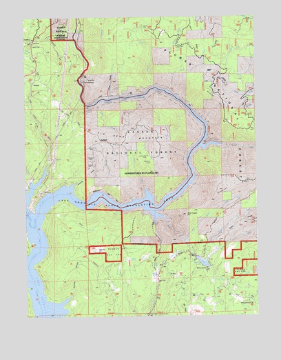
Berry Creek, CA USGS Topographic Map
Click on map above to begin viewing in our Map Viewer.

This topographic map contains these locations and features:
Feature Name Type Latitude Longitude GNIS ID View Map
Berry CreekPopulated PlaceN39.6452°W121.4033°1658040View Map
Berry CreekStreamN39.6652°W121.4250°256846View Map
Berry Creek BarBarN39.6727°W121.4344°1723841View Map
Berry Creek Census Designated PlaceCensusN39.6314°W121.4052°2612472View Map
Berry Creek DitchCanalN39.6488°W121.4244°256848View Map
Berry Creek Elementary SchoolSchoolN39.6393°W121.4302°256850View Map
Berry Creek Station (historical)LocaleN39.6704°W121.4355°1723842View Map
Bidwell CreekStreamN39.7185°W121.3780°256867View Map
Big BendPopulated PlaceN39.6982°W121.4608°1658048View Map
Big Bend MineMineN39.6893°W121.4339°256887View Map
Big Bend MountainSummitN39.6971°W121.4475°1658050View Map
Big Ripples (historical)Populated PlaceN39.6271°W121.4925°1723845View Map
Blinzing (historical)Populated PlaceN39.7138°W121.4136°1723847View Map
Bloomer HillSummitN39.6516°W121.4630°257217View Map
Bloomer RavineValleyN39.6332°W121.4772°257220View Map
Brush (historical)Populated PlaceN39.6963°W121.4058°1723849View Map
Bunker Hill MineMineN39.6952°W121.4666°257691View Map
California Department of Forestry and Fire Protection Station 36 Jarbo GapBuildingN39.7391°W121.4960°2622345View Map
California Department of Forestry and Fire Protection Station 62 Harts MillBuildingN39.6257°W121.4344°2622349View Map
China GulchValleyN39.7160°W121.4561°258306View Map
Chino CreekStreamN39.7193°W121.4236°258323View Map
Chino RidgeRidgeN39.7402°W121.4091°258324View Map
Dark CanyonValleyN39.6893°W121.4889°259053View Map
David (historical)Populated PlaceN39.7171°W121.4550°1723853View Map
Evening Star MineMineN39.6918°W121.4352°259991View Map
Frazier CreekStreamN39.6779°W121.4372°260349View Map
French CreekStreamN39.6960°W121.4061°260381View Map
Frenchmans GraveLocaleN39.7366°W121.4183°275971View Map
Galen CreekStreamN39.6518°W121.3986°260457View Map
Galen RidgeRidgeN39.6635°W121.3858°260458View Map
Goat Ranch CampgroundLocaleN39.6552°W121.4977°260625View Map
Goat Ranch Recreation AreaParkN39.6546°W121.4986°1723860View Map
Grizzly CreekStreamN39.6816°W121.4975°260914View Map
Hornet MineMineN39.7452°W121.4350°275972View Map
Hughes PlacePopulated PlaceN39.7277°W121.4022°1658798View Map
Isaiah (historical)Populated PlaceN39.7177°W121.4422°1723865View Map
Island BarBarN39.6771°W121.4802°1723866View Map
Jack CreekStreamN39.7171°W121.3802°261849View Map
Jarbo GapGapN39.7377°W121.4969°261902View Map
Lake Madrone 1004 DamDamN39.6499°W121.4077°1664117View Map
Las Plumas (historical)Populated PlaceN39.6735°W121.4861°1723870View Map
Last Chance CreekStreamN39.7285°W121.4166°262329View Map
Linden SpringSpringN39.6485°W121.4452°262491View Map
Madrone LakeReservoirN39.6475°W121.4055°227928View Map
Martin CreekStreamN39.6488°W121.4030°263234View Map
Moseley (historical)Populated PlaceN39.6416°W121.4302°1723874View Map
New Blinzing (historical)Populated PlaceN39.7188°W121.4219°1723875View Map
Nolton CreekStreamN39.7135°W121.4625°229572View Map
North Fork Feather RiverStreamN39.7241°W121.4719°264163View Map
ParkhillPopulated PlaceN39.7224°W121.4966°1659346View Map
Pipers (historical)Populated PlaceN39.6818°W121.4816°1723893View Map
PoePopulated PlaceN39.7443°W121.4714°1659409View Map
Poe PowerhouseLocaleN39.7229°W121.4700°1654384View Map
Rock CreekStreamN39.7160°W121.4555°1723894View Map
Rockefeller SchoolSchoolN39.6304°W121.3791°275974View Map
Rose Ranch (historical)LocaleN39.7263°W121.3816°1723895View Map
Rose SchoolSchoolN39.7271°W121.3825°275976View Map
Shields GulchValleyN39.6804°W121.4747°266116View Map
South Fork Berry CreekStreamN39.6429°W121.3769°267427View Map
Stony CreekStreamN39.7207°W121.4316°267780View Map
Surcease MineMineN39.6896°W121.4661°267984View Map
Swayne HillSummitN39.7227°W121.4033°268012View Map
Treasure Hill MineMineN39.7046°W121.4327°275975View Map
Tunnel Number SevenTunnelN39.6907°W121.4919°268477View Map
Wild Yankee CreekStreamN39.6566°W121.4158°269085View Map
Wild Yankee HillSummitN39.6671°W121.4144°269086View Map

Note: Coordinates in the location and feature list above are referenced to NAD83 datum.


Copyright (C) 2008-2024 Ryan Niemi / Sunset Dynamics ... All Rights Reserved