TopoQuest Logo
Do you find TopoQuest useful?
Help keep TopoQuest running and adding new maps/features by donating!
Bitcoin:  19c7KJd3qBynnjoSw5npx9KScwjBe4ifkT
Litecoin:  LXs6TkuXGGXo1vDsWCkWVdjQX94eUKd6ui
Home View Maps Find Maps Find Places Resources & Links


Oroville Dam, California Topographic Map

USGS Map Title: Oroville Dam, CA
USGS Map MRC: 39121E4
DRG (GeoTIFF) Download: o39121e4.tif


Neighboring USGS Topographic Map Quads:


  Cherokee, CA  
39121F5
 

  Berry Creek, CA  
39121F4
 

  Brush Creek, CA  
39121F3
 

  Oroville, CA  
39121E5
 

  Oroville Dam, CA  
39121E4
 

  Forbestown, CA  
39121E3
 

  Palermo, CA  
39121D5
 

  Bangor, CA  
39121D4
 

  Rackerby, CA  
39121D3


Map MRC Location:

N40°
W122°
N40°
W121°
H8 H7 H6 H5 H4 H3 H2 H1
G8 G7 G6 G5 G4 G3 G2 G1
F8 F7 F6 F5 F4 F3 F2 F1
E8 E7 E6 E5 E4 E3 E2 E1
D8 D7 D6 D5 D4 D3 D2 D1
C8 C7 C6 C5 C4 C3 C2 C1
B8 B7 B6 B5 B4 B3 B2 B1
A8 A7 A6 A5 A4 A3 A2 A1
N39°
W122°
N39°
W121°

Oroville Dam, CA USGS 1:24K Topographic Map Preview:
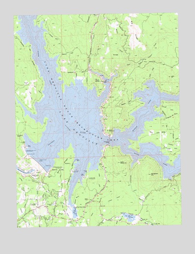
Oroville Dam, CA USGS Topographic Map
Click on map above to begin viewing in our Map Viewer.

This topographic map contains these locations and features:
Feature Name Type Latitude Longitude GNIS ID View Map
Atkins School (historical)SchoolN39.5038°W121.4052°1666762View Map
Bidwell (historical)Populated PlaceN39.5568°W121.4655°1666764View Map
Bidwell Bar (historical)Populated PlaceN39.5566°W121.4414°1666765View Map
Bidwell Bar BridgeBridgeN39.5493°W121.4297°252009View Map
Bidwell Bar CanyonValleyN39.5538°W121.4469°1666766View Map
Bidwell Bar Canyon Saddle DamDamN39.5118°W121.4575°219106View Map
Bidwell Canyon CampgroundLocaleN39.5332°W121.4586°219107View Map
Bidwell Canyon MarinaLocaleN39.5327°W121.4561°1723843View Map
Big RidgeRidgeN39.6174°W121.4102°266452View Map
Bloomer (historical)Populated PlaceN39.6243°W121.4914°1666768View Map
Bloomer Primitive Recreation AreaParkN39.6185°W121.4972°1723848View Map
Box Hall FlatFlatN39.5846°W121.4911°219732View Map
Buffalo RanchLocaleN39.5054°W121.4086°1666769View Map
Butte County Fire Department Station 64BuildingN39.5135°W121.4863°2622312View Map
Canyon CreekStreamN39.5929°W121.4430°257946View Map
Canyon Creek BridgeBridgeN39.5852°W121.4302°252011View Map
Craig (historical)Populated PlaceN39.5477°W121.3875°1666775View Map
Craig Recreation AreaParkN39.5521°W121.3997°1723937View Map
Deadman RavineValleyN39.5135°W121.4575°222126View Map
East Fork Canyon CreekStreamN39.5913°W121.4236°259717View Map
First Responder Emergency Medical Services Station 23BuildingN39.5109°W121.4887°2662287View Map
Foreman CreekStreamN39.5877°W121.4541°223670View Map
Foreman Creek Recreation AreaParkN39.5863°W121.4608°1723858View Map
Harts Mill (historical)LocaleN39.6235°W121.4366°1723962View Map
Hawk Ravine (historical)Populated PlaceN39.5143°W121.4391°1723862View Map
Jamison Ranch (historical)LocaleN39.6193°W121.4202°1666786View Map
Kelly RidgeRidgeN39.5357°W121.4652°226477View Map
Kelly Ridge Census Designated PlaceCensusN39.5288°W121.4663°2612483View Map
Kelly Ridge Fire StationBuildingN39.5138°W121.4861°226479View Map
Kelly Ridge Golf CourseLocaleN39.5332°W121.4741°1723868View Map
Kelly Ridge Recreation AreaParkN39.5396°W121.4650°1723869View Map
Kelly Ridge TunnelTunnelN39.5163°W121.4694°226478View Map
Kennedy RavineValleyN39.6149°W121.4755°226507View Map
Lake OrovilleReservoirN39.5517°W121.4235°264404View Map
Lake Oroville Landing Area Seaplane BaseAirportN39.5663°W121.4686°1653788View Map
Lake Oroville State Recreation AreaParkN39.5635°W121.4564°266892View Map
Lake WyandotteReservoirN39.5054°W121.4167°238209View Map
Lake Wyandotte 63 DamDamN39.5060°W121.4202°1663500View Map
Land (historical)Populated PlaceN39.5535°W121.4677°1666789View Map
Lanigan GulchValleyN39.5710°W121.3900°226861View Map
Lave Oroville Visitors CenterBuildingN39.5352°W121.4666°1723972View Map
Loafer CreekStreamN39.5321°W121.4397°227447View Map
Loafer Creek CampgroundLocaleN39.5282°W121.4455°227448View Map
Loafer Creek Recreation AreaParkN39.5235°W121.4475°1723871View Map
Miller BarBarN39.5588°W121.4080°1666792View Map
Miners RanchLocaleN39.5085°W121.4644°1666793View Map
Miners Ranch 63-009 DamDamN39.5113°W121.4586°1663508View Map
Miners Ranch ReservoirReservoirN39.5082°W121.4573°228796View Map
Miners Ranch TunnelTunnelN39.5157°W121.4264°228797View Map
Minnie CreekStreamN39.5952°W121.4150°228806View Map
Montgomery BarBarN39.5657°W121.4016°1666795View Map
Montgomery Bar RavineValleyN39.5635°W121.3877°228973View Map
Mount HopeSummitN39.6007°W121.4258°1658776View Map
Mount RatchelSummitN39.5868°W121.4377°231246View Map
Oregon GulchValleyN39.5427°W121.3877°264389View Map
Oroville 1-048 DamDamN39.5349°W121.4827°1663249View Map
Oroville DamDamN39.5388°W121.4855°230109View Map
Palermo CanalCanalN39.5063°W121.4947°230252View Map
Potter RavineValleyN39.5657°W121.4814°230998View Map
Potters Ravine Recreation AreaParkN39.5577°W121.4869°1723892View Map
Quartz (historical)Populated PlaceN39.5327°W121.4983°1666796View Map
Rocky BarBarN39.5535°W121.4125°1666800View Map
Schaefer RanchLocaleN39.6032°W121.4305°1666801View Map
South Bidwell HillSummitN39.5371°W121.4219°1659819View Map
South Fork (historical)Populated PlaceN39.5407°W121.4205°1666802View Map
Spillway Boat RampLocaleN39.5477°W121.4925°1723899View Map
Spring HollowValleyN39.5557°W121.4014°235269View Map
Stringtown BarBarN39.5327°W121.3855°1666804View Map
Stringtown MountainSummitN39.5299°W121.3989°235598View Map
Sycamore CreekStreamN39.5746°W121.4108°235919View Map
Sycamore CreekStreamN39.6013°W121.4664°235920View Map
Sycamore Creek Recreation AreaParkN39.5718°W121.4041°1724008View Map
Union BarBarN39.5757°W121.3941°1666805View Map
Union CreekStreamN39.5860°W121.3983°236790View Map
Union HillSummitN39.5874°W121.3822°236829View Map
Woodman RavineValleyN39.5338°W121.4136°238141View Map

Note: Coordinates in the location and feature list above are referenced to NAD83 datum.


Copyright (C) 2008-2025 Ryan Niemi / Sunset Dynamics ... All Rights Reserved