TopoQuest Logo
Do you find TopoQuest useful?
Help keep TopoQuest running and adding new maps/features by donating!
Bitcoin:  19c7KJd3qBynnjoSw5npx9KScwjBe4ifkT
Litecoin:  LXs6TkuXGGXo1vDsWCkWVdjQX94eUKd6ui
Home View Maps Find Maps Find Places Resources & Links


Forbestown, California Topographic Map

USGS Map Title: Forbestown, CA
USGS Map MRC: 39121E3
DRG (GeoTIFF) Download: o39121e3.tif


Neighboring USGS Topographic Map Quads:


  Berry Creek, CA  
39121F4
 

  Brush Creek, CA  
39121F3
 

  Cascade, CA  
39121F2
 

  Oroville Dam, CA  
39121E4
 

  Forbestown, CA  
39121E3
 

  Clipper Mills, CA  
39121E2
 

  Bangor, CA  
39121D4
 

  Rackerby, CA  
39121D3
 

  Challenge, CA  
39121D2


Map MRC Location:

N40°
W122°
N40°
W121°
H8 H7 H6 H5 H4 H3 H2 H1
G8 G7 G6 G5 G4 G3 G2 G1
F8 F7 F6 F5 F4 F3 F2 F1
E8 E7 E6 E5 E4 E3 E2 E1
D8 D7 D6 D5 D4 D3 D2 D1
C8 C7 C6 C5 C4 C3 C2 C1
B8 B7 B6 B5 B4 B3 B2 B1
A8 A7 A6 A5 A4 A3 A2 A1
N39°
W122°
N39°
W121°

Forbestown, CA USGS 1:24K Topographic Map Preview:
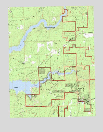
Forbestown, CA USGS Topographic Map
Click on map above to begin viewing in our Map Viewer.

This topographic map contains these locations and features:
Feature Name Type Latitude Longitude GNIS ID View Map
BALD ROCK INDIAN CEMETERYCemeteryN39.6010°W121.3622°261714View Map
Bean CreekStreamN39.6096°W121.3277°256612View Map
Bean Creek BarBarN39.6091°W121.3264°1666763View Map
Bryant RavineValleyN39.6224°W121.2700°257555View Map
Butte County Fire Department Station 52BuildingN39.5928°W121.2570°2622320View Map
Butte County Fire Department Station 61BuildingN39.6245°W121.3729°2622322View Map
Carlysle MineMineN39.5449°W121.2705°1666770View Map
Cedar RavineValleyN39.5985°W121.3183°258143View Map
Coon RavineValleyN39.5432°W121.3255°258685View Map
Crystal HillSummitN39.5671°W121.3705°1655941View Map
Day MeadowFlatN39.5010°W121.2866°259104View Map
Denver MineMineN39.5416°W121.2997°1666776View Map
Enterprise (historical)Populated PlaceN39.5363°W121.3641°1666778View Map
Enterprise BridgeBridgeN39.5360°W121.3394°259946View Map
Enterprise RancheriaCivilN39.5616°W121.3555°259950View Map
Fairfield BarBarN39.5802°W121.3580°1666779View Map
Feather FallsPopulated PlaceN39.5932°W121.2564°1656010View Map
Feather Falls Census Designated PlaceCensusN39.5920°W121.2630°2612479View Map
Feather Falls Elementary SchoolSchoolN39.5939°W121.2638°1723945View Map
ForbestownPopulated PlaceN39.5171°W121.2672°1656023View Map
Forbestown Census Designated PlaceCensusN39.5300°W121.2689°2612480View Map
Forbestown Post OfficePost OfficeN39.5189°W121.2760°2769366View Map
Forbestown PowerhouseLocaleN39.5507°W121.2786°260239View Map
Forbestown RavineValleyN39.5421°W121.2666°260240View Map
Forbestown TunnelTunnelN39.5527°W121.2594°260241View Map
Island Bar HillSummitN39.5854°W121.3258°1656095View Map
Jack Hill RavineValleyN39.5849°W121.3527°261850View Map
Kanaka BarBarN39.6004°W121.3177°1666788View Map
Kanaka CreekStreamN39.5996°W121.3136°262069View Map
Kanaka PeakSummitN39.5824°W121.3044°262075View Map
Little Sucker RunStreamN39.5635°W121.2877°262732View Map
McCabe CreekStreamN39.5207°W121.3450°263301View Map
Midas MineMineN39.5416°W121.3108°1666791View Map
Miners Ranch CanalCanalN39.5338°W121.3327°263680View Map
Mooretown RidgeRidgeN39.5743°W121.3055°263806View Map
Mosquito GulchValleyN39.5366°W121.2664°263866View Map
Nutmeg CreekStreamN39.6038°W121.3014°264259View Map
Old ForbestownPopulated PlaceN39.5279°W121.2808°1656196View Map
Oroville Wyandotte CanalCanalN39.5146°W121.2958°267098View Map
Ponderosa Diversion DamDamN39.5488°W121.3044°264922View Map
Ponderosa ReservoirReservoirN39.5493°W121.2925°264924View Map
Powell CreekStreamN39.5246°W121.3655°265017View Map
Roadside SpringSpringN39.5032°W121.3141°265442View Map
Rocky Point PeakSummitN39.5499°W121.3566°265544View Map
South Fork Feather RiverStreamN39.5485°W121.2775°267458View Map
Southern Cross MineMineN39.5466°W121.3166°1666803View Map
Sucker RunStreamN39.5535°W121.3064°267831View Map
Sunset HillSummitN39.5238°W121.2997°267972View Map

Note: Coordinates in the location and feature list above are referenced to NAD83 datum.


Copyright (C) 2008-2025 Ryan Niemi / Sunset Dynamics ... All Rights Reserved