TopoQuest Logo
Do you find TopoQuest useful?
Help keep TopoQuest running and adding new maps/features by donating!
Bitcoin:  19c7KJd3qBynnjoSw5npx9KScwjBe4ifkT
Litecoin:  LXs6TkuXGGXo1vDsWCkWVdjQX94eUKd6ui
Home View Maps Find Maps Find Places Resources & Links


Perham, Minnesota Topographic Map

USGS Map Title: Perham, MN
USGS Map MRC: 46095E5
DRG (GeoTIFF) Download: o46095e5.tif


Neighboring USGS Topographic Map Quads:


  Frazee, MN  
46095F6
 

  Little Pine Lake, MN  
46095F5
 

  New York Mills NW, MN  
46095F4
 

  Dent, MN  
46095E6
 

  Perham, MN  
46095E5
 

  New York Mills West, MN  
46095E4
 

  Walker Lake, MN  
46095D6
 

  Ottertail, MN  
46095D5
 

  Heinola, MN  
46095D4


Map MRC Location:

N47°
W96°
N47°
W95°
H8 H7 H6 H5 H4 H3 H2 H1
G8 G7 G6 G5 G4 G3 G2 G1
F8 F7 F6 F5 F4 F3 F2 F1
E8 E7 E6 E5 E4 E3 E2 E1
D8 D7 D6 D5 D4 D3 D2 D1
C8 C7 C6 C5 C4 C3 C2 C1
B8 B7 B6 B5 B4 B3 B2 B1
A8 A7 A6 A5 A4 A3 A2 A1
N46°
W96°
N46°
W95°

Perham, MN USGS 1:24K Topographic Map Preview:
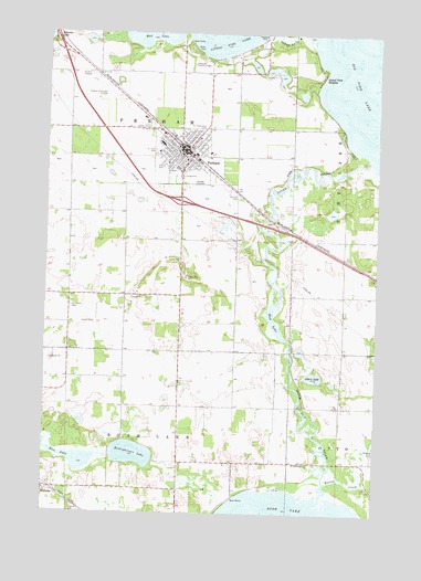
Perham, MN USGS Topographic Map
Click on map above to begin viewing in our Map Viewer.

This topographic map contains these locations and features:
Feature Name Type Latitude Longitude GNIS ID View Map
Albert LakeLakeN46.5356°W95.5235°639246View Map
Arvig ParkParkN46.6014°W95.5278°2072765View Map
Assembly of God ChurchChurchN46.5961°W95.5789°2072743View Map
Bible Baptist ChurchChurchN46.6006°W95.5606°2072745View Map
Boedigheimer LakeLakeN46.5152°W95.5915°640322View Map
Calvary Lutheran ChurchChurchN46.5911°W95.5797°2072742View Map
Church of ChristChurchN46.5972°W95.5789°2072738View Map
City Hall ParkParkN46.5944°W95.5717°2072762View Map
City of PerhamCivilN46.5989°W95.5742°2396181View Map
Country Pines ParkParkN46.6028°W95.5783°2072764View Map
East Ottertail ClinicHospitalN46.5933°W95.5739°2072756View Map
Grand View HeightsPopulated PlaceN46.6133°W95.5231°644335View Map
Hagen AirportAirportN46.5015°W95.6129°660375View Map
Heart of the Lake Elementary SchoolSchoolN46.5883°W95.5806°2072753View Map
History Museum of East Otter Tail CountyBuildingN46.5956°W95.5700°2072749View Map
Krauss ParkParkN46.5919°W95.5823°646249View Map
Lake's Mobile Home ParkPopulated PlaceN46.5944°W95.5722°2072760View Map
Lakeside Country ClubLocaleN46.6169°W95.5706°659873View Map
Little Pine LakeReservoirN46.6233°W95.5403°1776265View Map
Little Pine Lake DamDamN46.6233°W95.5403°1776264View Map
Miller ParkParkN46.6211°W95.5703°647880View Map
Mud LakeLakeN46.5482°W95.5379°648305View Map
Museum/Library ParkParkN46.5956°W95.5700°2072761View Map
Northern Pacific ParkParkN46.5956°W95.5750°2072763View Map
PerhamLocaleN46.5967°W95.5750°2072758View Map
PerhamPopulated PlaceN46.5944°W95.5725°649298View Map
Perham Area Emergency Medical ServicesBuildingN46.5971°W95.5785°2721351View Map
Perham CemeteryCemeteryN46.5825°W95.5528°649299View Map
Perham Community ChurchChurchN46.6000°W95.5833°2072739View Map
Perham FairgroundsLocaleN46.5883°W95.5708°2074371View Map
Perham Fire DepartmentBuildingN46.5971°W95.5784°2072746View Map
Perham High SchoolSchoolN46.5900°W95.5753°2072755View Map
Perham LibraryBuildingN46.5953°W95.5694°2072750View Map
Perham Memorial Hospital and HomeHospitalN46.5963°W95.5822°2072757View Map
Perham Memorial Hospital HeliportAirportN46.5950°W95.5839°660351View Map
Perham Meritcare ClinicHospitalN46.5964°W95.5814°2074372View Map
Perham Municipal AirportAirportN46.6106°W95.6037°660349View Map
Perham Police DepartmentBuildingN46.5971°W95.5785°2072747View Map
Perham Post Office (historical)Post OfficeN46.5958°W95.5747°2072748View Map
Pine Cone CourtPopulated PlaceN46.6008°W95.5883°2072759View Map
Pine LakeReservoirN46.5916°W95.5053°1776263View Map
Pine Lake Big DamDamN46.5916°W95.5053°1776262View Map
Pioneer VillageParkN46.6056°W95.5667°2074373View Map
Prairie Wind Middle SchoolSchoolN46.5878°W95.5842°2072754View Map
Rice LakeLakeN46.5137°W95.6125°650027View Map
Saint Henry CemeteryCemeteryN46.6013°W95.5856°650605View Map
Saint Henry's Catholic ChurchChurchN46.5944°W95.5758°2072737View Map
Saint Henry's SchoolSchoolN46.5939°W95.5753°2072752View Map
Saint Joseph CemeteryCemeteryN46.5533°W95.6156°650759View Map
Saint Lawrence ChurchChurchN46.5130°W95.5250°650789View Map
Saint Lawrence Church CemeteryCemeteryN46.5139°W95.5267°2072665View Map
Saint Lawrence Post Office (historical)Post OfficeN46.5333°W95.6083°2072980View Map
Saint Paul CemeteryCemeteryN46.5944°W95.5848°650961View Map
Saint Paul's Lutheran ChurchChurchN46.5942°W95.5831°2072744View Map
Saint Paul's Lutheran SchoolSchoolN46.5969°W95.5792°2072751View Map
Saint Stanislaus CemeteryCemeteryN46.6000°W95.5667°651053View Map
Saint Stanislaus ChurchChurchN46.5978°W95.5675°2072740View Map
Township of PerhamCivilN46.5843°W95.5976°665285View Map
United Methodist ChurchChurchN46.5928°W95.5711°2072741View Map
United Methodist ChurchChurchN46.5064°W95.6247°2072780View Map
Willow CreekStreamN46.5080°W95.5184°654190View Map

Note: Coordinates in the location and feature list above are referenced to NAD83 datum.


Copyright (C) 2008-2024 Ryan Niemi / Sunset Dynamics ... All Rights Reserved