TopoQuest Logo
Do you find TopoQuest useful?
Help keep TopoQuest running and adding new maps/features by donating!
Bitcoin:  19c7KJd3qBynnjoSw5npx9KScwjBe4ifkT
Litecoin:  LXs6TkuXGGXo1vDsWCkWVdjQX94eUKd6ui
Home View Maps Find Maps Find Places Resources & Links


Berryhill Creek, Texas Topographic Map

USGS Map Title: Berryhill Creek, TX
USGS Map MRC: 32094A7
DRG (GeoTIFF) Download: o32094a7.tif


Neighboring USGS Topographic Map Quads:


  Price, TX  
32094B8
 

  Henderson, TX  
32094B7
 

  Church Hill, TX  
32094B6
 

  Gum Springs, TX  
32094A8
 

  Berryhill Creek, TX  
32094A7
 

  Minden, TX  
32094A6
 

  New Salem, TX  
31094H8
 

  Laneville, TX  
31094H7
 

  Mount Enterprise, TX  
31094H6


Map MRC Location:

N33°
W95°
N33°
W94°
H8 H7 H6 H5 H4 H3 H2 H1
G8 G7 G6 G5 G4 G3 G2 G1
F8 F7 F6 F5 F4 F3 F2 F1
E8 E7 E6 E5 E4 E3 E2 E1
D8 D7 D6 D5 D4 D3 D2 D1
C8 C7 C6 C5 C4 C3 C2 C1
B8 B7 B6 B5 B4 B3 B2 B1
A8 A7 A6 A5 A4 A3 A2 A1
N32°
W95°
N32°
W94°

Berryhill Creek, TX USGS 1:24K Topographic Map Preview:
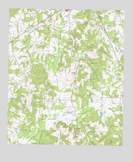
Berryhill Creek, TX USGS Topographic Map
Click on map above to begin viewing in our Map Viewer.

This topographic map contains these locations and features:
Feature Name Type Latitude Longitude GNIS ID View Map
Barnhardt CreekStreamN32.0232°W94.8263°1330074View Map
Berryhill CreekStreamN32.0527°W94.8202°1330460View Map
Bethel ChurchChurchN32.0757°W94.7841°1330493View Map
Bethel CreekStreamN32.0854°W94.7944°1330512View Map
Bromley CreekStreamN32.1113°W94.8149°1331305View Map
Chinquapin CreekStreamN32.0096°W94.7897°1332780View Map
Crow CemeteryCemeteryN32.1218°W94.7544°1333737View Map
Davis CemeteryCemeteryN32.1077°W94.8283°1334086View Map
Eaton LakeReservoirN32.0300°W94.8084°1864182View Map
Eaton Lake DamDamN32.0302°W94.8102°1864181View Map
Ebenezer ChurchChurchN32.1118°W94.7797°1335063View Map
Good Hope ChurchChurchN32.1238°W94.7591°1336690View Map
Gum BranchStreamN32.0124°W94.8402°1337114View Map
Hays CreekStreamN32.0321°W94.7530°1337513View Map
HickeyPopulated PlaceN32.0943°W94.8724°1380858View Map
J A Morris DamDamN32.0385°W94.7835°1861220View Map
Jarrell CreekStreamN32.0329°W94.7533°1338645View Map
KJMD-AM (Laneville)TowerN32.0957°W94.7994°1385610View Map
Laneville ChurchChurchN32.0079°W94.7985°1339615View Map
Lockridge CemeteryCemeteryN32.0643°W94.8510°1340309View Map
Mill CreekStreamN32.0235°W94.7999°1374941View Map
Minden CreekStreamN32.0368°W94.7730°1329135View Map
Mission Springs ChurchChurchN32.1246°W94.7597°1341752View Map
Morris LakeReservoirN32.0318°W94.7802°1861219View Map
Morris Lake DamDamN32.0318°W94.7802°1861218View Map
Mount Olive ChurchChurchN32.0438°W94.8580°1342075View Map
Parker CreekStreamN32.0716°W94.8247°1343600View Map
Prairie BranchStreamN32.0063°W94.8460°1344482View Map
Rusk CountyCivilN32.1077°W94.7619°1383986View Map
Sand BranchStreamN32.0268°W94.8241°1346495View Map
Shawnee CreekStreamN32.0232°W94.8263°1346994View Map
Shelton LakeReservoirN32.0099°W94.8650°1861226View Map
Shelton Lake DamDamN32.0118°W94.8635°1861225View Map
Turkey CreekStreamN32.0721°W94.8255°1348872View Map
Union Grove ChurchChurchN32.0510°W94.7894°1349062View Map
Walker BranchStreamN32.0879°W94.7524°1349369View Map
Youngblood DamDamN32.0802°W94.7969°1861217View Map

Note: Coordinates in the location and feature list above are referenced to NAD83 datum.


Copyright (C) 2008-2025 Ryan Niemi / Sunset Dynamics ... All Rights Reserved