TopoQuest Logo
Do you find TopoQuest useful?
Help keep TopoQuest running and adding new maps/features by donating!
Bitcoin:  19c7KJd3qBynnjoSw5npx9KScwjBe4ifkT
Litecoin:  LXs6TkuXGGXo1vDsWCkWVdjQX94eUKd6ui
Home View Maps Find Maps Find Places Resources & Links


Phillipsburg, Missouri Topographic Map

USGS Map Title: Phillipsburg, MO
USGS Map MRC: 37092E7
DRG (GeoTIFF) Download: o37092e7.tif


Neighboring USGS Topographic Map Quads:


  Windyville, MO  
37092F8
 

  Bennett Springs, MO  
37092F7
 

  Lebanon, MO  
37092F6
 

  Long Lane, MO  
37092E8
 

  Phillipsburg, MO  
37092E7
 

  Brush Creek, MO  
37092E6
 

  Beach, MO  
37092D8
 

  Niangua, MO  
37092D7
 

  Rader, MO  
37092D6


Map MRC Location:

N38°
W93°
N38°
W92°
H8 H7 H6 H5 H4 H3 H2 H1
G8 G7 G6 G5 G4 G3 G2 G1
F8 F7 F6 F5 F4 F3 F2 F1
E8 E7 E6 E5 E4 E3 E2 E1
D8 D7 D6 D5 D4 D3 D2 D1
C8 C7 C6 C5 C4 C3 C2 C1
B8 B7 B6 B5 B4 B3 B2 B1
A8 A7 A6 A5 A4 A3 A2 A1
N37°
W93°
N37°
W92°

Phillipsburg, MO USGS 1:24K Topographic Map Preview:
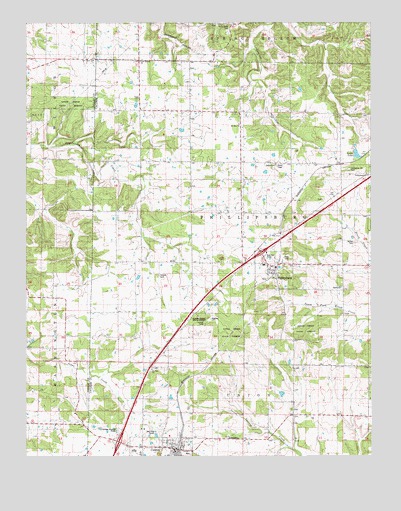
Phillipsburg, MO USGS Topographic Map
Click on map above to begin viewing in our Map Viewer.

This topographic map contains these locations and features:
Feature Name Type Latitude Longitude GNIS ID View Map
BrittainPopulated PlaceN37.5498°W92.8638°740520View Map
City of ConwayCivilN37.5057°W92.8313°2393623View Map
ConwayPopulated PlaceN37.5020°W92.8210°716212View Map
Conway Post OfficePost OfficeN37.5030°W92.8263°2782958View Map
Conway Volunteer Fire DepartmentBuildingN37.5013°W92.8210°2620288View Map
Huben (historical)Populated PlaceN37.5873°W92.7516°740945View Map
Jacobs LakeReservoirN37.5870°W92.7553°738230View Map
Lees Summit ChurchChurchN37.6139°W92.8338°742191View Map
Lonesome Hill CemeteryCemeteryN37.5825°W92.7588°742190View Map
Lonesome Hill School (historical)SchoolN37.5825°W92.7605°721489View Map
McFall CemeteryCemeteryN37.5620°W92.7563°722101View Map
Mount Zion ChurchChurchN37.5956°W92.7980°722953View Map
Mount Zion SchoolSchoolN37.5925°W92.8241°722977View Map
New Hope ChurchChurchN37.6137°W92.8507°723250View Map
Oak Summit School (historical)SchoolN37.5998°W92.8718°723656View Map
PhillipsburgPopulated PlaceN37.5539°W92.7849°724299View Map
Phillipsburg ChurchChurchN37.5809°W92.7513°742189View Map
Phillipsburg Post OfficePost OfficeN37.5540°W92.7852°2782722View Map
Porto Farms Lake DamDamN37.5184°W92.7818°765141View Map
Rocky Knob CemeteryCemeteryN37.6239°W92.8013°742192View Map
Salem SchoolSchoolN37.5039°W92.7688°725944View Map
Shanks CemeteryCemeteryN37.5520°W92.8271°726266View Map
South View SchoolSchoolN37.5342°W92.8605°726795View Map
Stony Point School (historical)SchoolN37.5467°W92.7599°735025View Map
Township of PhillipsburgCivilN37.5763°W92.7664°766865View Map
Twilight ChurchChurchN37.5250°W92.8296°742188View Map
Twilight SchoolSchoolN37.5287°W92.8288°727922View Map
Union Hill SchoolSchoolN37.5567°W92.8243°735896View Map
Village of PhillipsburgCivilN37.5525°W92.7871°2399663View Map

Note: Coordinates in the location and feature list above are referenced to NAD83 datum.


Copyright (C) 2008-2025 Ryan Niemi / Sunset Dynamics ... All Rights Reserved