TopoQuest Logo
Do you find TopoQuest useful?
Help keep TopoQuest running and adding new maps/features by donating!
Bitcoin:  19c7KJd3qBynnjoSw5npx9KScwjBe4ifkT
Litecoin:  LXs6TkuXGGXo1vDsWCkWVdjQX94eUKd6ui
Home View Maps Find Maps Find Places Resources & Links


Windyville, Missouri Topographic Map

USGS Map Title: Windyville, MO
USGS Map MRC: 37092F8
DRG (GeoTIFF) Download: o37092f8.tif


Neighboring USGS Topographic Map Quads:


  Tunas, MO  
37093G1
 

  Leadmine, MO  
37092G8
 

  Eldridge West, MO  
37092G7
 

  Buffalo, MO  
37093F1
 

  Windyville, MO  
37092F8
 

  Bennett Springs, MO  
37092F7
 

  Charity, MO  
37093E1
 

  Long Lane, MO  
37092E8
 

  Phillipsburg, MO  
37092E7


Map MRC Location:

N38°
W93°
N38°
W92°
H8 H7 H6 H5 H4 H3 H2 H1
G8 G7 G6 G5 G4 G3 G2 G1
F8 F7 F6 F5 F4 F3 F2 F1
E8 E7 E6 E5 E4 E3 E2 E1
D8 D7 D6 D5 D4 D3 D2 D1
C8 C7 C6 C5 C4 C3 C2 C1
B8 B7 B6 B5 B4 B3 B2 B1
A8 A7 A6 A5 A4 A3 A2 A1
N37°
W93°
N37°
W92°

Windyville, MO USGS 1:24K Topographic Map Preview:
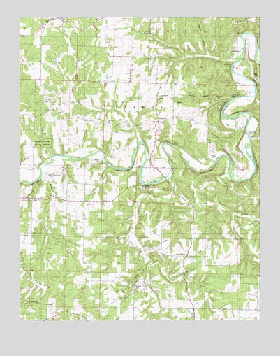
Windyville, MO USGS Topographic Map
Click on map above to begin viewing in our Map Viewer.

This topographic map contains these locations and features:
Feature Name Type Latitude Longitude GNIS ID View Map
Bell ForkStreamN37.6525°W92.9363°713909View Map
Benton BranchStreamN37.6898°W92.9852°713965View Map
Benton Branch ChurchChurchN37.6848°W92.9835°729989View Map
Bramwell BluffCliffN37.6867°W92.9457°738237View Map
Bramwell BranchStreamN37.6887°W92.9535°738236View Map
Burtin BluffCliffN37.6984°W92.9210°738239View Map
Camp AuroraLocaleN37.7181°W92.8868°742207View Map
Cansler SchoolSchoolN37.6323°W92.8757°735548View Map
Cat HollowValleyN37.7325°W92.8882°715488View Map
Cave CreekStreamN37.6853°W92.8893°715511View Map
Cedar RidgePopulated PlaceN37.6517°W92.9130°737876View Map
Cedar Ridge ChurchChurchN37.6537°W92.9127°715616View Map
Cedar Ridge School (historical)SchoolN37.6623°W92.9121°715617View Map
County Road HollowValleyN37.7162°W92.8902°738244View Map
Cowan BluffCliffN37.6806°W92.9318°738238View Map
Cudd SchoolSchoolN37.7478°W92.8843°716579View Map
Dallas County Community ChurchChurchN37.6753°W92.9932°742200View Map
Dallion Ford (historical)Populated PlaceN37.6862°W92.9888°740791View Map
Dry ForkStreamN37.6484°W92.9324°717106View Map
Durington CreekStreamN37.6823°W92.9963°717208View Map
Eberhart School (historical)SchoolN37.7023°W92.8955°735591View Map
English Bennett Ford (historical)LocaleN37.6842°W92.9216°717595View Map
Flanagan BluffCliffN37.6900°W92.8771°738240View Map
Fourmile CemeteryCemeteryN37.6389°W92.9399°742199View Map
Fourmile Church (historical)ChurchN37.6395°W92.9405°735003View Map
Fourmile CreekStreamN37.6837°W92.9224°718130View Map
Fourmile School (historical)SchoolN37.6384°W92.9407°718132View Map
Freeman BluffCliffN37.7114°W92.8852°738242View Map
Granny HollowValleyN37.7353°W92.9013°718697View Map
Hackler Ford (historical)Populated PlaceN37.6928°W92.9746°740895View Map
Hackler Ford State ForestForestN37.6987°W92.9885°742201View Map
Hildebrand BluffCliffN37.7142°W92.8941°738243View Map
Hildebrand CemeteryCemeteryN37.7175°W92.9268°742206View Map
Hutton Lake DamDamN37.7234°W92.9552°765403View Map
Indian CreekStreamN37.6978°W92.9374°720109View Map
Jerktail BranchStreamN37.6853°W92.9869°738234View Map
Kahler BluffCliffN37.7306°W92.8918°738246View Map
London Smoke ChurchChurchN37.6737°W92.9649°742202View Map
London Smoke School (historical)SchoolN37.6734°W92.9655°721437View Map
Lone Rock CemeteryCemeteryN37.7068°W92.9525°2681495View Map
Lone Rock ChurchChurchN37.7073°W92.9532°721459View Map
Lone Rock SchoolSchoolN37.7067°W92.9613°721461View Map
Mary Sharp BluffCliffN37.7214°W92.8763°738245View Map
Moon Valley Access PointLocaleN37.7023°W92.8827°742204View Map
North HollowValleyN37.7345°W92.9124°723474View Map
Pepers SchoolSchoolN37.7164°W92.9263°724219View Map
Peppers CemeteryCemeteryN37.7145°W92.9188°742205View Map
Phillips CemeteryCemeteryN37.6928°W92.9007°742203View Map
PladPopulated PlaceN37.7486°W92.9755°724452View Map
Plad CemeteryCemeteryN37.7492°W92.9842°2681500View Map
Plad SchoolSchoolN37.7484°W92.9610°724453View Map
Schoolhouse HollowValleyN37.7078°W92.8882°738241View Map
Scrivner CemeteryCemeteryN37.7284°W92.9430°742208View Map
Smith BluffCliffN37.6817°W92.9919°738235View Map
Sugartree Airport (historical)AirportN37.6389°W92.9891°758608View Map
TildenPopulated PlaceN37.7062°W92.9605°740121View Map
Township of JasperCivilN37.7131°W92.9348°766567View Map
Williams CemeteryCemeteryN37.6900°W92.9580°728886View Map
WindyvillePopulated PlaceN37.7067°W92.9271°728994View Map
Windyville ChurchChurchN37.7164°W92.9263°743394View Map
Windyville Volunteer Fire DepartmentBuildingN37.7068°W92.9285°2621683View Map

Note: Coordinates in the location and feature list above are referenced to NAD83 datum.


Copyright (C) 2008-2024 Ryan Niemi / Sunset Dynamics ... All Rights Reserved