TopoQuest Logo
Do you find TopoQuest useful?
Help keep TopoQuest running and adding new maps/features by donating!
Bitcoin:  19c7KJd3qBynnjoSw5npx9KScwjBe4ifkT
Litecoin:  LXs6TkuXGGXo1vDsWCkWVdjQX94eUKd6ui
Home View Maps Find Maps Find Places Resources & Links


Pickering, Missouri Topographic Map

USGS Map Title: Pickering, MO
USGS Map MRC: 40094D7
DRG (GeoTIFF) Download: o40094d7.tif


Neighboring USGS Topographic Map Quads:


  Hopkins SW, MO  
40094E8
 

  Hopkins, MO  
40094E7
 

  Bedford SW, MO  
40094E6
 

  Wilcox, MO  
40094D8
 

  Pickering, MO  
40094D7
 

  Parnell West, MO  
40094D6
 

  Maryville West, MO  
40094C8
 

  Maryville East, MO  
40094C7
 

  Ravenwood, MO  
40094C6


Map MRC Location:

N41°
W95°
N41°
W94°
H8 H7 H6 H5 H4 H3 H2 H1
G8 G7 G6 G5 G4 G3 G2 G1
F8 F7 F6 F5 F4 F3 F2 F1
E8 E7 E6 E5 E4 E3 E2 E1
D8 D7 D6 D5 D4 D3 D2 D1
C8 C7 C6 C5 C4 C3 C2 C1
B8 B7 B6 B5 B4 B3 B2 B1
A8 A7 A6 A5 A4 A3 A2 A1
N40°
W95°
N40°
W94°

Pickering, MO USGS 1:24K Topographic Map Preview:
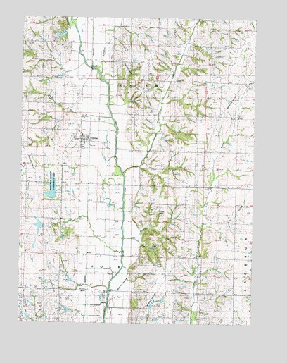
Pickering, MO USGS Topographic Map
Click on map above to begin viewing in our Map Viewer.

This topographic map contains these locations and features:
Feature Name Type Latitude Longitude GNIS ID View Map
102 River Tributaries Watershed 9 DamDamN40.3767°W94.8036°760748View Map
102 River Tributaries Watershed 9 LakeReservoirN40.3766°W94.8019°760749View Map
102 River Tributaries Watershed Dam C-5DamN40.4150°W94.8636°761646View Map
102 River Tributaries Watershed Number 12 DamDamN40.3817°W94.8052°760750View Map
102 River Tributaries Watershed Number 4 DamDamN40.3850°W94.7986°762427View Map
102 River Tributaries Watershed Structure LT-36 DamDamN40.3933°W94.8469°761930View Map
Bloomdale School (historical)SchoolN40.4308°W94.7805°714382View Map
Bloomfield SchoolSchoolN40.4178°W94.8405°714386View Map
Canal BranchStreamN40.4000°W94.8194°715332View Map
Coleman CemeteryCemeteryN40.4498°W94.8577°716110View Map
Excelsior School (historical)SchoolN40.4014°W94.7602°741842View Map
Ezcelsior SchoolSchoolN40.4017°W94.7608°766156View Map
Glendale SchoolSchoolN40.4630°W94.8705°718511View Map
Gray CemeteryCemeteryN40.4588°W94.8668°718764View Map
Happy Hollow School (historical)SchoolN40.4855°W94.7650°719074View Map
Harmon CreekStreamN40.4555°W94.8239°719104View Map
Jack HollowValleyN40.4075°W94.8086°720194View Map
Long HollowValleyN40.4150°W94.7747°721544View Map
Mount Pleasant SchoolSchoolN40.4364°W94.8716°722880View Map
Mowery School (historical)SchoolN40.4508°W94.8422°723003View Map
Mozingo Valley School (historical)SchoolN40.4594°W94.7591°730160View Map
Myrtle Tree School (historical)SchoolN40.3983°W94.7966°723106View Map
Nodaway County Community LakeReservoirN40.4299°W94.8581°737957View Map
Nodaway Lake DamDamN40.4250°W94.8586°760476View Map
Nodaway Number 4 LakeReservoirN40.3826°W94.8039°760751View Map
North Nodaway Elementary SchoolSchoolN40.4519°W94.8424°2545321View Map
Norvey CreekStreamN40.4364°W94.8205°723523View Map
Parman LakeReservoirN40.3804°W94.8497°761929View Map
Parman Lake DamDamN40.3800°W94.8486°761928View Map
PickeringPopulated PlaceN40.4508°W94.8422°724305View Map
Pickering Post OfficePost OfficeN40.4510°W94.8397°2782579View Map
Pinhook CreekStreamN40.4103°W94.8183°724406View Map
Pinhook HillsRangeN40.4250°W94.7983°724407View Map
Randall LakeReservoirN40.4061°W94.8039°725096View Map
Robbins LakeReservoirN40.4934°W94.8566°761934View Map
Robbins Lake DamDamN40.4933°W94.8552°761933View Map
Robbins Lake Dam DownstreamDamN40.4950°W94.8519°761931View Map
Robbins Lake DownstreamReservoirN40.4929°W94.8536°761932View Map
Slaughter BranchStreamN40.4767°W94.8319°726537View Map
Town of PickeringCivilN40.4503°W94.8415°2396855View Map
Township of UnionCivilN40.4668°W94.8331°767096View Map
Union School (historical)SchoolN40.3892°W94.8525°728042View Map
White Oak CemeteryCemeteryN40.4629°W94.8107°728778View Map
Wilson Lake DamDamN40.4650°W94.7502°761096View Map
Xenia SchoolSchoolN40.4825°W94.8050°729181View Map

Note: Coordinates in the location and feature list above are referenced to NAD83 datum.


Copyright (C) 2008-2025 Ryan Niemi / Sunset Dynamics ... All Rights Reserved