TopoQuest Logo
Do you find TopoQuest useful?
Help keep TopoQuest running and adding new maps/features by donating!
Bitcoin:  19c7KJd3qBynnjoSw5npx9KScwjBe4ifkT
Litecoin:  LXs6TkuXGGXo1vDsWCkWVdjQX94eUKd6ui
Home View Maps Find Maps Find Places Resources & Links


Piedmont Hollow, Missouri Topographic Map

USGS Map Title: Piedmont Hollow, MO
USGS Map MRC: 36091G4
DRG (GeoTIFF) Download: o36091g4.tif


Neighboring USGS Topographic Map Quads:


  Montier, MO  
36091H5
 

  Birch Tree, MO  
36091H4
 

  Low Wassie, MO  
36091H3
 

  Thomasville, MO  
36091G5
 

  Piedmont Hollow, MO  
36091G4
 

  Greer, MO  
36091G3
 

  Rover, MO  
36091F5
 

  Alton, MO  
36091F4
 

  Many Springs, MO  
36091F3


Map MRC Location:

N37°
W92°
N37°
W91°
H8 H7 H6 H5 H4 H3 H2 H1
G8 G7 G6 G5 G4 G3 G2 G1
F8 F7 F6 F5 F4 F3 F2 F1
E8 E7 E6 E5 E4 E3 E2 E1
D8 D7 D6 D5 D4 D3 D2 D1
C8 C7 C6 C5 C4 C3 C2 C1
B8 B7 B6 B5 B4 B3 B2 B1
A8 A7 A6 A5 A4 A3 A2 A1
N36°
W92°
N36°
W91°

Piedmont Hollow, MO USGS 1:24K Topographic Map Preview:
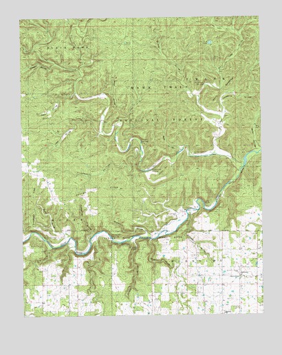
Piedmont Hollow, MO USGS Topographic Map
Click on map above to begin viewing in our Map Viewer.

This topographic map contains these locations and features:
Feature Name Type Latitude Longitude GNIS ID View Map
BandyvilleLocaleN36.8417°W91.4076°740522View Map
Bandyville Post OfficePost OfficeN36.8417°W91.4076°760050View Map
Becky HollowValleyN36.8192°W91.3776°748755View Map
Bee Fork CreekStreamN36.8531°W91.4699°748763View Map
Betsy HollowValleyN36.8320°W91.4493°714115View Map
Blowing SpringSpringN36.7831°W91.4549°714391View Map
Blubbering HollowValleyN36.7814°W91.4660°714393View Map
Blue Ridge TrailTrailN36.8551°W91.4126°754003View Map
Blue Ridge Trail TrailheadLocaleN36.8556°W91.3799°754002View Map
Bockman SpringSpringN36.8464°W91.4049°714468View Map
Bryan School (historical)SchoolN36.7662°W91.4018°714934View Map
Buck HollowValleyN36.8201°W91.4182°714966View Map
Bull Camp HollowValleyN36.8334°W91.3960°715025View Map
Camp HollowValleyN36.8267°W91.4596°715271View Map
Camp House SpringSpringN36.8317°W91.4704°715272View Map
Cane BluffCliffN36.7964°W91.4043°715336View Map
Cane Bluff Access Ramp Canoe DockLocaleN36.7953°W91.4060°755605View Map
Cane Bluff HollowValleyN36.7970°W91.4010°735167View Map
Cave Spring HollowValleyN36.7789°W91.4868°715548View Map
Church of ChristChurchN36.7659°W91.3871°743135View Map
Cooper SpringSpringN36.8214°W91.4382°716289View Map
Cumberland ChurchChurchN36.7673°W91.3876°729999View Map
Denny HollowValleyN36.7820°W91.4337°716838View Map
Denny Hollow Float CampLocaleN36.7839°W91.4329°755606View Map
Devils BackboneRidgeN36.8442°W91.3954°716855View Map
Doniphan HollowValleyN36.7931°W91.4121°716977View Map
Dry CreekStreamN36.7849°W91.4604°717087View Map
Eleven Point National Scenic RiverParkN36.8573°W91.3832°754123View Map
Elm PondLakeN36.7509°W91.3944°735166View Map
George RidgeRidgeN36.8045°W91.4610°718399View Map
Graham HollowValleyN36.7812°W91.4432°718657View Map
Graham SpringSpringN36.7787°W91.4415°718660View Map
Granddaddy RidgeRidgeN36.8031°W91.4949°718683View Map
Hickory Grove CemeteryCemeteryN36.7681°W91.3879°743136View Map
Hog HollowValleyN36.8623°W91.4935°719679View Map
Jackson HollowValleyN36.8137°W91.4218°720216View Map
Jenny HollowValleyN36.8251°W91.4432°720305View Map
Johnson HollowValleyN36.8553°W91.4829°720373View Map
Low Wassie CreekStreamN36.8176°W91.3999°735165View Map
Macedonia ChurchChurchN36.7509°W91.3960°729997View Map
Macedonia SchoolSchoolN36.7520°W91.3965°735164View Map
Mine HollowValleyN36.8281°W91.3782°751109View Map
Orchard HollowValleyN36.7845°W91.4362°723843View Map
Paty HollowValleyN36.8434°W91.4724°724100View Map
Paty PondLakeN36.8642°W91.4457°724101View Map
Paty SpringSpringN36.8417°W91.4746°724102View Map
Piedmont HollowValleyN36.8181°W91.4387°724316View Map
Pine Hill School (historical)SchoolN36.8289°W91.4999°735161View Map
Posy SpringSpringN36.7842°W91.4907°724787View Map
Roaring SpringSpringN36.7803°W91.4510°725375View Map
Round HollowValleyN36.7834°W91.4760°725602View Map
Sheep Ranch HollowValleyN36.8698°W91.3890°752101View Map
Spring CreekStreamN36.8127°W91.3841°752307View Map
Spring Creek CemeteryCemeteryN36.8175°W91.4110°743137View Map
Spring Creek SchoolSchoolN36.8203°W91.4004°726912View Map
Thompson SpringSpringN36.8109°W91.4343°727612View Map
Threemile HollowValleyN36.8203°W91.3987°752542View Map
Township of WoodsideCivilN36.8078°W91.3879°767116View Map
Tupelo Gum PondLakeN36.8642°W91.4012°727836View Map
Twin SpringsSpringN36.8584°W91.4004°727931View Map
Union Church (historical)ChurchN36.8162°W91.3907°735163View Map
Union FordLocaleN36.8120°W91.3846°735162View Map
Well HollowValleyN36.8698°W91.3896°752798View Map
Wolfpen HollowValleyN36.8426°W91.4093°752962View Map

Note: Coordinates in the location and feature list above are referenced to NAD83 datum.


Copyright (C) 2008-2025 Ryan Niemi / Sunset Dynamics ... All Rights Reserved