TopoQuest Logo
Do you find TopoQuest useful?
Help keep TopoQuest running and adding new maps/features by donating!
Bitcoin:  19c7KJd3qBynnjoSw5npx9KScwjBe4ifkT
Litecoin:  LXs6TkuXGGXo1vDsWCkWVdjQX94eUKd6ui
Home View Maps Find Maps Find Places Resources & Links


Low Wassie, Missouri Topographic Map

USGS Map Title: Low Wassie, MO
USGS Map MRC: 36091H3
DRG (GeoTIFF) Download: o36091h3.tif


Neighboring USGS Topographic Map Quads:


  Bartlett, MO  
37091A4
 

  Winona, MO  
37091A3
 

  Stegall Mountain, MO  
37091A2
 

  Birch Tree, MO  
36091H4
 

  Low Wassie, MO  
36091H3
 

  Fremont, MO  
36091H2
 

  Piedmont Hollow, MO  
36091G4
 

  Greer, MO  
36091G3
 

  Wilderness, MO  
36091G2


Map MRC Location:

N37°
W92°
N37°
W91°
H8 H7 H6 H5 H4 H3 H2 H1
G8 G7 G6 G5 G4 G3 G2 G1
F8 F7 F6 F5 F4 F3 F2 F1
E8 E7 E6 E5 E4 E3 E2 E1
D8 D7 D6 D5 D4 D3 D2 D1
C8 C7 C6 C5 C4 C3 C2 C1
B8 B7 B6 B5 B4 B3 B2 B1
A8 A7 A6 A5 A4 A3 A2 A1
N36°
W92°
N36°
W91°

Low Wassie, MO USGS 1:24K Topographic Map Preview:
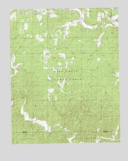
Low Wassie, MO USGS Topographic Map
Click on map above to begin viewing in our Map Viewer.

This topographic map contains these locations and features:
Feature Name Type Latitude Longitude GNIS ID View Map
Barnlog HollowValleyN36.8853°W91.2532°748684View Map
Bear HollowValleyN36.9164°W91.3585°748734View Map
Davis HollowValleyN36.9014°W91.3612°749586View Map
Deep PondLakeN36.9523°W91.2855°749603View Map
Deep Pond HollowValleyN36.9826°W91.2515°749604View Map
Edmondson PondLakeN36.9420°W91.2855°749804View Map
Folk PondLakeN36.9717°W91.3199°749954View Map
Grassy PondLakeN36.9731°W91.3002°750112View Map
Horse Trough HollowValleyN36.9573°W91.3712°753621View Map
Independence SchoolSchoolN36.9445°W91.3212°750448View Map
Little Bear HollowValleyN36.9173°W91.3590°750731View Map
Low WassiePopulated PlaceN36.9887°W91.2582°750881View Map
Marg PondLakeN36.9762°W91.2592°750929View Map
Martin SpringSpringN36.9164°W91.3721°753617View Map
Mount Zion CemeteryCemeteryN36.9903°W91.2946°753620View Map
Mount Zion SchoolSchoolN36.9806°W91.3024°751208View Map
Nichols LakeReservoirN36.9605°W91.2902°753618View Map
Pond HollowValleyN36.8984°W91.3482°751697View Map
Pond Hollow SchoolSchoolN36.8989°W91.3474°751700View Map
Possum Trot HollowValleyN36.8889°W91.3118°751722View Map
Possum Trot Lookout (historical)LocaleN36.9281°W91.3340°751724View Map
Reed HollowValleyN36.8778°W91.2579°751843View Map
Saltpetre HollowValleyN36.8951°W91.3482°752018View Map
Seaman CreekStreamN36.9887°W91.2929°752069View Map
Shady Grove Church (historical)ChurchN36.8895°W91.3151°752089View Map
South Crooked HollowValleyN36.8887°W91.3371°752250View Map
Spring HollowValleyN36.8770°W91.2601°752319View Map
Sunnyside School (historical)SchoolN36.9189°W91.2596°752433View Map
Sycamore CreekStreamN36.9901°W91.2599°752472View Map
Tram LookoutLocaleN36.9881°W91.3599°752578View Map
Tram PondReservoirN36.9628°W91.3223°753619View Map
Twinpine Picnic AreaLocaleN36.9934°W91.3040°755604View Map
Whiteoak HollowValleyN36.8970°W91.3126°752867View Map
Wildcat HollowValleyN36.8828°W91.3010°752890View Map

Note: Coordinates in the location and feature list above are referenced to NAD83 datum.


Copyright (C) 2008-2024 Ryan Niemi / Sunset Dynamics ... All Rights Reserved