TopoQuest Logo
Do you find TopoQuest useful?
Help keep TopoQuest running and adding new maps/features by donating!
Bitcoin:  19c7KJd3qBynnjoSw5npx9KScwjBe4ifkT
Litecoin:  LXs6TkuXGGXo1vDsWCkWVdjQX94eUKd6ui
Home View Maps Find Maps Find Places Resources & Links


Rover, Missouri Topographic Map

USGS Map Title: Rover, MO
USGS Map MRC: 36091F5
DRG (GeoTIFF) Download: o36091f5.tif


Neighboring USGS Topographic Map Quads:


  Peace Valley, MO  
36091G6
 

  Thomasville, MO  
36091G5
 

  Piedmont Hollow, MO  
36091G4
 

  Brandsville, MO  
36091F6
 

  Rover, MO  
36091F5
 

  Alton, MO  
36091F4
 

  Koshkonong, MO  
36091E6
 

  Thayer, MO  
36091E5
 

  Couch, MO  
36091E4


Map MRC Location:

N37°
W92°
N37°
W91°
H8 H7 H6 H5 H4 H3 H2 H1
G8 G7 G6 G5 G4 G3 G2 G1
F8 F7 F6 F5 F4 F3 F2 F1
E8 E7 E6 E5 E4 E3 E2 E1
D8 D7 D6 D5 D4 D3 D2 D1
C8 C7 C6 C5 C4 C3 C2 C1
B8 B7 B6 B5 B4 B3 B2 B1
A8 A7 A6 A5 A4 A3 A2 A1
N36°
W92°
N36°
W91°

Rover, MO USGS 1:24K Topographic Map Preview:
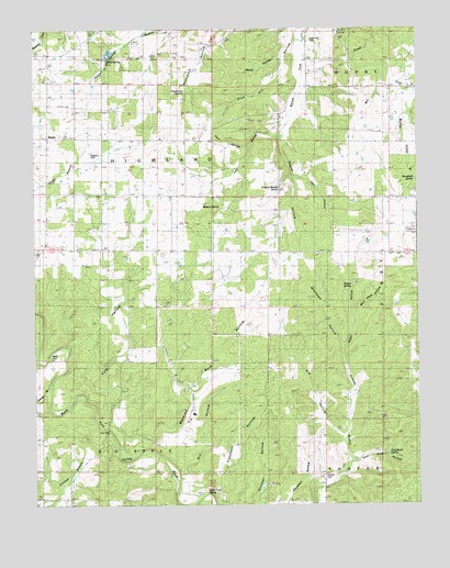
Rover, MO USGS Topographic Map
Click on map above to begin viewing in our Map Viewer.

This topographic map contains these locations and features:
Feature Name Type Latitude Longitude GNIS ID View Map
Bales School (historical)SchoolN36.6951°W91.5668°713600View Map
Black HollowValleyN36.7420°W91.5451°714291View Map
Brady (historical)LocaleN36.7437°W91.5196°740549View Map
Brady Post OfficePost OfficeN36.7437°W91.5196°760051View Map
Cave HollowValleyN36.7195°W91.5557°715518View Map
Cold Rock HollowValleyN36.6367°W91.5218°716079View Map
Cold Rock SpringSpringN36.6379°W91.5097°716080View Map
Culp FordPopulated PlaceN36.6445°W91.6018°740787View Map
Culp HollowValleyN36.6387°W91.5954°716586View Map
Dry HollowValleyN36.6276°W91.5718°717118View Map
Elliot FordPopulated PlaceN36.6626°W91.6224°740829View Map
Elm HollowValleyN36.6423°W91.5254°717525View Map
English SchoolSchoolN36.6989°W91.6032°717598View Map
Granny Meyers SpringSpringN36.7084°W91.5450°718698View Map
Hay HollowValleyN36.7114°W91.5407°719251View Map
Howell CemeteryCemeteryN36.6328°W91.5307°719927View Map
Howell CreekStreamN36.6767°W91.5999°750409View Map
James BranchStreamN36.6562°W91.6210°720244View Map
Jolliff GraveyardCemeteryN36.7431°W91.5893°735182View Map
Jolliff School (historical)SchoolN36.7434°W91.5907°720390View Map
Jolliff SpringSpringN36.7418°W91.6011°720391View Map
Lost HollowValleyN36.7214°W91.5457°754128View Map
Mount Pleasant School (historical)SchoolN36.6253°W91.5593°722869View Map
Oak Grove SchoolSchoolN36.6264°W91.6229°723590View Map
Orchard CreekStreamN36.6445°W91.6018°723840View Map
Pine Hill HollowValleyN36.7484°W91.5399°735780View Map
Ragan HollowValleyN36.6664°W91.5254°725061View Map
Ragan SpringSpringN36.6823°W91.5221°725062View Map
Redburn CemeteryCemeteryN36.7176°W91.6068°743171View Map
Redburn ChurchChurchN36.7176°W91.6076°725168View Map
RoverPopulated PlaceN36.7217°W91.6210°741216View Map
Rover Volunteer Fire DepartmentBuildingN36.7191°W91.6203°2621672View Map
Sycamore SpringSpringN36.7336°W91.5761°727419View Map
Thayer HollowValleyN36.7203°W91.5443°727548View Map
Township of HighlandCivilN36.7150°W91.6000°767106View Map
Union Hill CemeteryCemeteryN36.7470°W91.5349°743170View Map
Union Hill Church (historical)ChurchN36.7462°W91.5351°735181View Map
Warm Fork SpringSpringN36.6281°W91.5694°728352View Map
Watered Rock HollowValleyN36.6423°W91.5951°728405View Map
Watson SpringSpringN36.7037°W91.5675°728428View Map
Whitooak HollowValleyN36.6664°W91.5254°728800View Map
Wolf Cave HollowValleyN36.6745°W91.5204°729034View Map
Woodside SpringSpringN36.7105°W91.5009°729128View Map

Note: Coordinates in the location and feature list above are referenced to NAD83 datum.


Copyright (C) 2008-2025 Ryan Niemi / Sunset Dynamics ... All Rights Reserved