TopoQuest Logo
Do you find TopoQuest useful?
Help keep TopoQuest running and adding new maps/features by donating!
Bitcoin:  19c7KJd3qBynnjoSw5npx9KScwjBe4ifkT
Litecoin:  LXs6TkuXGGXo1vDsWCkWVdjQX94eUKd6ui
Home View Maps Find Maps Find Places Resources & Links


Plymouth East, North Carolina Topographic Map

USGS Map Title: Plymouth East, NC
USGS Map MRC: 35076G6
DRG (GeoTIFF) Download: o35076g6.tif


Neighboring USGS Topographic Map Quads:


  Woodard, NC  
35076H7
 

  Westover, NC  
35076H6
 

  Roper North, NC  
35076H5
 

  Plymouth West, NC  
35076G7
 

  Plymouth East, NC  
35076G6
 

  Roper South, NC  
35076G5
 

  Hoke, NC  
35076F7
 

  Pike Road, NC  
35076F6
 

  Pungo Lake, NC  
35076F5


Map MRC Location:

N36°
W77°
N36°
W76°
H8 H7 H6 H5 H4 H3 H2 H1
G8 G7 G6 G5 G4 G3 G2 G1
F8 F7 F6 F5 F4 F3 F2 F1
E8 E7 E6 E5 E4 E3 E2 E1
D8 D7 D6 D5 D4 D3 D2 D1
C8 C7 C6 C5 C4 C3 C2 C1
B8 B7 B6 B5 B4 B3 B2 B1
A8 A7 A6 A5 A4 A3 A2 A1
N35°
W77°
N35°
W76°

Plymouth East, NC USGS 1:24K Topographic Map Preview:
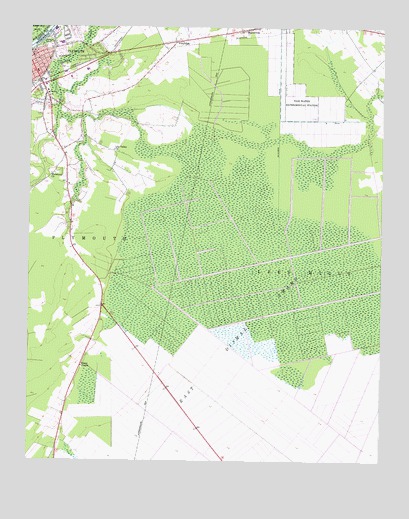
Plymouth East, NC USGS Topographic Map
Click on map above to begin viewing in our Map Viewer.

This topographic map contains these locations and features:
Feature Name Type Latitude Longitude GNIS ID View Map
Fourth Street Elementary SchoolSchoolN35.8657°W76.7291°1003417View Map
Green Hill (historical)Populated PlaceN35.8677°W76.7197°1003432View Map
Hopkins Mobile Home ParkPopulated PlaceN35.8344°W76.7370°2505610View Map
Lily Valley ChurchChurchN35.8399°W76.7197°988490View Map
Monticello (historical)Populated PlaceN35.7657°W76.7363°1018707View Map
Morattock ChurchChurchN35.8329°W76.7419°990212View Map
Pettigrew Regional Library and Washington County LibraryBuildingN35.8654°W76.7477°2505960View Map
PineridgePopulated PlaceN35.8707°W76.6980°1021937View Map
Plumblee Nursing CenterBuildingN35.8635°W76.7269°2505806View Map
PlymouthPopulated PlaceN35.8668°W76.7486°992600View Map
Plymouth High SchoolSchoolN35.8703°W76.7381°1003418View Map
Plymouth Methodist ChurchChurchN35.8668°W76.7486°1003448View Map
Plymouth Police DepartmentBuildingN35.8679°W76.7499°2130984View Map
Plymouth Shopping CenterLocaleN35.8582°W76.7444°1007702View Map
Sawyers Mobile Home ParkPopulated PlaceN35.8260°W76.7367°2505579View Map
Skinners CanalCanalN35.8504°W76.6613°994883View Map
Tide Water Experimental StationLocaleN35.8593°W76.6591°996100View Map
Town of PlymouthCivilN35.8587°W76.7487°2407138View Map
Township of Lees MillCivilN35.8425°W76.6268°1027290View Map
Township of PlymouthCivilN35.7930°W76.7472°1027291View Map
Union ChapelChurchN35.7777°W76.7308°996436View Map
Washington County CourthouseBuildingN35.8621°W76.7472°1003415View Map
Washington County Emergency Medical ServicesBuildingN35.8621°W76.7294°2720500View Map
Washington County HospitalHospitalN35.8628°W76.7292°2701521View Map
Washington County Sheriff's OfficeBuildingN35.8670°W76.7489°2130947View Map
Washington Street Elementary SchoolSchoolN35.8624°W76.7474°1003416View Map

Note: Coordinates in the location and feature list above are referenced to NAD83 datum.


Copyright (C) 2008-2025 Ryan Niemi / Sunset Dynamics ... All Rights Reserved