TopoQuest Logo
Do you find TopoQuest useful?
Help keep TopoQuest running and adding new maps/features by donating!
Bitcoin:  19c7KJd3qBynnjoSw5npx9KScwjBe4ifkT
Litecoin:  LXs6TkuXGGXo1vDsWCkWVdjQX94eUKd6ui
Home View Maps Find Maps Find Places Resources & Links


Pilot Hill, California Topographic Map

USGS Map Title: Pilot Hill, CA
USGS Map MRC: 38121G1
DRG (GeoTIFF) Download: o38121g1.tif


Neighboring USGS Topographic Map Quads:


  Gold Hill, CA  
38121H2
 

  Auburn, CA  
38121H1
 

  Greenwood, CA  
38120H8
 

  Rocklin, CA  
38121G2
 

  Pilot Hill, CA  
38121G1
 

  Coloma, CA  
38120G8
 

  Folsom, CA  
38121F2
 

  Clarksville, CA  
38121F1
 

  Shingle Springs, CA  
38120F8


Map MRC Location:

N39°
W122°
N39°
W121°
H8 H7 H6 H5 H4 H3 H2 H1
G8 G7 G6 G5 G4 G3 G2 G1
F8 F7 F6 F5 F4 F3 F2 F1
E8 E7 E6 E5 E4 E3 E2 E1
D8 D7 D6 D5 D4 D3 D2 D1
C8 C7 C6 C5 C4 C3 C2 C1
B8 B7 B6 B5 B4 B3 B2 B1
A8 A7 A6 A5 A4 A3 A2 A1
N38°
W122°
N38°
W121°

Pilot Hill, CA USGS 1:24K Topographic Map Preview:
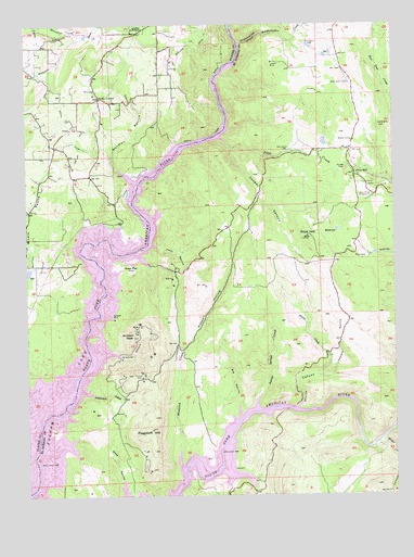
Pilot Hill, CA USGS Topographic Map
Click on map above to begin viewing in our Map Viewer.

This topographic map contains these locations and features:
Feature Name Type Latitude Longitude GNIS ID View Map
Acorn CreekStreamN38.7743°W121.0330°217961View Map
Aeree 2463 DamDamN38.8432°W121.0244°1664373View Map
Anderson CreekStreamN38.7771°W121.1027°218251View Map
Anderson Island Natural PreserveReserveN38.7918°W121.1038°1733815View Map
Averys PondLakeN38.8302°W121.0914°1723480View Map
Bayley HouseBuildingN38.8441°W121.0149°218759View Map
Big RavineValleyN38.7738°W121.0544°219232View Map
Boardman CanalCanalN38.8691°W121.1119°257304View Map
Boulder MineMineN38.8368°W121.0172°219696View Map
Chrome MineMineN38.7816°W121.0869°221094View Map
Cooper CanyonValleyN38.8421°W121.0555°221519View Map
Department of Forestry and Fire Protection Station 70 Pilot HillBuildingN38.8319°W121.0094°2623987View Map
Dotsons Bar (historical)BarN38.7727°W121.1155°1670544View Map
El Dorado County Fire Protection District Station 73 Pilot HillBuildingN38.8432°W121.0151°2624518View Map
Flagstaff HillSummitN38.7677°W121.0838°223574View Map
Goose FlatLocaleN38.8116°W121.0938°224322View Map
Granite RavineValleyN38.7882°W121.0977°224417View Map
Hancock CreekStreamN38.7624°W121.0752°224865View Map
Herrington QuarryMineN38.8564°W121.1064°2677930View Map
Horseshoe Bar (historical)BarN38.8102°W121.1016°1670548View Map
Indian Springs CreekStreamN38.7766°W121.0469°225911View Map
KAHI-AM (Auburn)TowerN38.8577°W121.0286°1664848View Map
Kelly RavineValleyN38.8163°W121.0824°226475View Map
KFIA-AM (Carmichael)TowerN38.8607°W121.0336°1664858View Map
KHYL-FM (Auburn)TowerN38.8577°W121.0286°1665004View Map
Knickerbocker CanyonValleyN38.8699°W121.0527°226649View Map
Knickerbocker CreekStreamN38.8699°W121.0527°262221View Map
LakeshorePopulated PlaceN38.8152°W121.1127°1723489View Map
Monte Rio School (historical)SchoolN38.8274°W121.0969°1670551View Map
Mormon RavineValleyN38.8343°W121.0905°229065View Map
Natomas Diversion Dam (historical)DamN38.7730°W121.0399°1670536View Map
Newcastle CanalCanalN38.8730°W121.1116°229512View Map
North Fork DitchCanalN38.8560°W121.0597°229666View Map
Oregon Bar (historical)IslandN38.8638°W121.0566°1670535View Map
Peacock RavineValleyN38.7821°W121.0222°230437View Map
Pilot CreekStreamN38.8441°W121.0580°230655View Map
Pilot HillPopulated PlaceN38.8349°W121.0144°230657View Map
Pilot HillSummitN38.8182°W121.0297°230658View Map
Pilot Hill CemeteryCemeteryN38.8296°W121.0091°230659View Map
Pilot Hill Post OfficePost OfficeN38.8403°W121.0156°2789170View Map
Placer County Fire Department Station 20 / South Placer Fire Department Station 5BuildingN38.8245°W121.1243°1723518View Map
Rattlesnake Bar (historical)BarN38.8160°W121.0897°1670553View Map
Rattlesnake Bridge (historical)BridgeN38.8143°W121.0913°1670537View Map
Russell HollowValleyN38.7891°W121.0730°232039View Map
Salmon FallsFallsN38.7591°W121.0699°1670539View Map
Salmon Falls (historical)Populated PlaceN38.7580°W121.0583°1670538View Map
Salmon Falls BridgeBridgeN38.7730°W121.0372°1733872View Map
Shirland CanalCanalN38.8702°W121.0702°233030View Map
Shirttail PeakSummitN38.7924°W121.0897°233034View Map
Skunk CanyonValleyN38.7732°W121.0344°233202View Map
South CanalCanalN38.8471°W121.1108°234946View Map
Sweetwater CreekStreamN38.7521°W121.0491°235898View Map
Umbrella HillSummitN38.8474°W121.0058°1660072View Map
Weber CreekStreamN38.7635°W121.0072°268833View Map
Whiskey Bar (historical)BarN38.8155°W121.1061°1670540View Map
Wildcat CanyonValleyN38.7605°W121.0005°237780View Map
Zantgraf MineMineN38.7968°W121.0961°238306View Map
Zee EstatesPopulated PlaceN38.7638°W121.0483°1733881View Map

Note: Coordinates in the location and feature list above are referenced to NAD83 datum.


Copyright (C) 2008-2024 Ryan Niemi / Sunset Dynamics ... All Rights Reserved