TopoQuest Logo
Do you find TopoQuest useful?
Help keep TopoQuest running and adding new maps/features by donating!
Bitcoin:  19c7KJd3qBynnjoSw5npx9KScwjBe4ifkT
Litecoin:  LXs6TkuXGGXo1vDsWCkWVdjQX94eUKd6ui
Home View Maps Find Maps Find Places Resources & Links


Greenwood, California Topographic Map

USGS Map Title: Greenwood, CA
USGS Map MRC: 38120H8
DRG (GeoTIFF) Download: o38120h8.tif


Neighboring USGS Topographic Map Quads:


  Lake Combie, CA  
39121A1
 

  Colfax, CA  
39120A8
 

  Foresthill, CA  
39120A7
 

  Auburn, CA  
38121H1
 

  Greenwood, CA  
38120H8
 

  Georgetown, CA  
38120H7
 

  Pilot Hill, CA  
38121G1
 

  Coloma, CA  
38120G8
 

  Garden Valley, CA  
38120G7


Map MRC Location:

N39°
W121°
N39°
W120°
H8 H7 H6 H5 H4 H3 H2 H1
G8 G7 G6 G5 G4 G3 G2 G1
F8 F7 F6 F5 F4 F3 F2 F1
E8 E7 E6 E5 E4 E3 E2 E1
D8 D7 D6 D5 D4 D3 D2 D1
C8 C7 C6 C5 C4 C3 C2 C1
B8 B7 B6 B5 B4 B3 B2 B1
A8 A7 A6 A5 A4 A3 A2 A1
N38°
W121°
N38°
W120°

Greenwood, CA USGS 1:24K Topographic Map Preview:
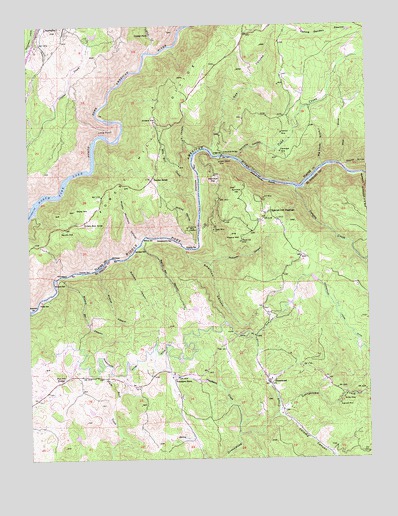
Greenwood, CA USGS Topographic Map
Click on map above to begin viewing in our Map Viewer.

This topographic map contains these locations and features:
Feature Name Type Latitude Longitude GNIS ID View Map
American CanyonValleyN38.9355°W120.9427°256217View Map
Applegate Branch Auburn-Placer County LibraryBuildingN38.9977°W120.9947°1723400View Map
Applegate Post OfficePost OfficeN38.9992°W120.9936°1723401View Map
Argonaut MineMineN38.8905°W120.8869°256316View Map
Auburn Lake TrailsPopulated PlaceN38.9143°W120.9524°1733728View Map
Auburn Lake Trails 3467 DamDamN38.9182°W120.9411°1664455View Map
Auburn Lake Trails Census Designated PlaceCensusN38.8916°W120.9849°2582982View Map
Big Snyder GulchValleyN38.9591°W120.8916°257010View Map
Boole 1320 DamDamN38.9966°W120.9761°1664297View Map
Bowman MineMineN38.9685°W120.9072°257404View Map
Browns BarBarN38.9260°W120.9911°257501View Map
Browns Bar CanyonValleyN38.9277°W120.9891°257502View Map
Brushy Mountain CanyonValleyN38.9368°W120.9597°257550View Map
Buckeye BarBarN38.9330°W120.9686°257598View Map
Buckeye CanyonValleyN38.9321°W120.9655°257599View Map
Butcher RanchLocaleN38.9560°W120.9541°257750View Map
Canyon CreekStreamN38.9527°W120.9019°257943View Map
Centennial MineMineN38.9413°W120.9419°258168View Map
Cherokee BarBarN38.9560°W120.9377°258236View Map
Cherokee FlatFlatN38.9552°W120.9322°258238View Map
Codfish CreekStreamN38.9924°W120.9547°258503View Map
Codfish FallsFallsN38.9971°W120.9547°258504View Map
Coloma CanyonValleyN38.8871°W120.9077°258601View Map
Drivers FlatFlatN38.9732°W120.9533°259533View Map
French HillSummitN38.9393°W120.9258°260393View Map
French Hill MineMineN38.9374°W120.9222°260394View Map
Garden Valley Fire Protection District Station 53BuildingN38.9048°W120.9168°2623678View Map
Gas CanyonValleyN38.9638°W120.9327°260497View Map
Georgetown CreekStreamN38.8885°W120.9094°260528View Map
Georgetown Fire Department Station 64 Sliger MineBuildingN38.9347°W120.9018°2624522View Map
GreenwoodPopulated PlaceN38.8966°W120.9127°260879View Map
Greenwood BridgeBridgeN38.9618°W120.9286°260880View Map
Greenwood Civilian Conservation Corps CampLocaleN38.9035°W120.9094°1733764View Map
Greenwood Post OfficePost OfficeN38.9052°W120.9169°2769428View Map
Grit MineMineN38.9499°W120.9138°260901View Map
Grizzly Bear HouseLocaleN38.9432°W120.9799°260903View Map
Heinz Gilbert MineMineN38.9605°W120.9294°261231View Map
Hoboken CanyonValleyN38.9316°W120.9338°261380View Map
Hoosier BarBarN38.9296°W120.9783°261451View Map
Kennebeck BarBarN38.9285°W120.9866°262130View Map
Long PointCliffN38.9702°W120.9697°262868View Map
Maine BarBarN38.9388°W120.9572°263128View Map
Maine Bar CanyonValleyN38.9368°W120.9588°263129View Map
Maltby MineMineN38.8921°W120.8852°263136View Map
Mile Hill CreekStreamN38.9557°W120.9374°263570View Map
New Orleans GulchValleyN38.9568°W120.8777°264059View Map
Niegel 2462 DamDamN38.8766°W120.9727°1664372View Map
Oregon BarBarN38.9621°W120.9311°264385View Map
Paradise CanyonValleyN38.9616°W120.9236°264505View Map
Penobscot CreekStreamN38.8818°W120.9238°264641View Map
Penobscot FarmLocaleN38.8977°W120.9477°264642View Map
Philadelphia BarBarN38.9385°W120.9505°264678View Map
Pilot Hill GrangeLocaleN38.8985°W120.9877°264734View Map
Poverty BarBarN38.9363°W120.9408°265012View Map
Ruck-A-Chucky RapidsRapidsN38.9552°W120.9127°265657View Map
Sardine BarBarN38.9349°W120.9622°265838View Map
Sharps RavineValleyN38.9427°W120.9377°266049View Map
Shenanigan MineMineN38.9632°W120.9074°266093View Map
Sliger MineMineN38.9407°W120.9319°266301View Map
Slug GulchValleyN38.9593°W120.8858°266307View Map
Spanish Dry DiggingsLocaleN38.9460°W120.9113°267549View Map
Spring Garden RavineValleyN38.9977°W120.9085°267597View Map
Squaw FlatFlatN38.9416°W120.9877°267624View Map
Squaw GulchValleyN38.9588°W120.8844°267627View Map
Stony HillSummitN38.9468°W120.9838°267789View Map
Summit HillSummitN38.9532°W120.9238°267920View Map
Texas BarBarN38.9206°W120.9964°268160View Map
Todd CreekStreamN38.9616°W120.9233°268314View Map
United States CanyonValleyN38.9630°W120.9388°268593View Map
Wildcat CanyonValleyN38.9293°W120.9752°269087View Map

Note: Coordinates in the location and feature list above are referenced to NAD83 datum.


Copyright (C) 2008-2024 Ryan Niemi / Sunset Dynamics ... All Rights Reserved