TopoQuest Logo
Do you find TopoQuest useful?
Help keep TopoQuest running and adding new maps/features by donating!
Bitcoin:  19c7KJd3qBynnjoSw5npx9KScwjBe4ifkT
Litecoin:  LXs6TkuXGGXo1vDsWCkWVdjQX94eUKd6ui
Home View Maps Find Maps Find Places Resources & Links


Pima, Arizona Topographic Map

USGS Map Title: Pima, AZ
USGS Map MRC: 32109H7
DRG (GeoTIFF) Download: o32109h7.tif


Neighboring USGS Topographic Map Quads:


  Fort Thomas, AZ  
33109A8
 

  Markham Creek, AZ  
33109A7
 

  Bryce Mountain, AZ  
33109A6
 

  Eden, AZ  
32109H8
 

  Pima, AZ  
32109H7
 

  Weber Peak, AZ  
32109H6
 

  Shingle Mill Mountain, AZ  
32109G8
 

  Thatcher, AZ  
32109G7
 

  Safford, AZ  
32109G6


Map MRC Location:

N33°
W110°
N33°
W109°
H8 H7 H6 H5 H4 H3 H2 H1
G8 G7 G6 G5 G4 G3 G2 G1
F8 F7 F6 F5 F4 F3 F2 F1
E8 E7 E6 E5 E4 E3 E2 E1
D8 D7 D6 D5 D4 D3 D2 D1
C8 C7 C6 C5 C4 C3 C2 C1
B8 B7 B6 B5 B4 B3 B2 B1
A8 A7 A6 A5 A4 A3 A2 A1
N32°
W110°
N32°
W109°

Pima, AZ USGS 1:24K Topographic Map Preview:
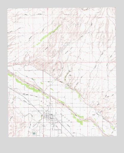
Pima, AZ USGS Topographic Map
Click on map above to begin viewing in our Map Viewer.

This topographic map contains these locations and features:
Feature Name Type Latitude Longitude GNIS ID View Map
Ash CreekStreamN32.9112°W109.8206°833View Map
Big SpringSpringN32.9387°W109.8053°1369View Map
Big Spring WashStreamN32.9228°W109.8092°1377View Map
Billingsley CreekStreamN32.9365°W109.8690°1416View Map
Billingsley DamDamN32.9467°W109.8506°22414View Map
Bluff HollowValleyN32.9362°W109.8284°1756View Map
BrycePopulated PlaceN32.9290°W109.8279°2051View Map
Bryce CemeteryCemeteryN32.9367°W109.8230°2052View Map
Bryce Census Designated PlaceCensusN32.9258°W109.8231°2582741View Map
Butler WashStreamN32.8931°W109.7848°2299View Map
Chesley WashStreamN32.9140°W109.7906°2799View Map
Chesley-Wamslee DamDamN32.9148°W109.7895°22450View Map
Cottonwood WashStreamN32.9145°W109.8276°3404View Map
Coyote WashStreamN32.9120°W109.7645°3523View Map
Dan Hinton Accommodation SchoolSchoolN32.8897°W109.8239°2544996View Map
Discovery Plus AcademySchoolN32.9015°W109.8451°2544993View Map
DublinPopulated PlaceN32.8962°W109.8342°4174View Map
East SpringSpringN32.9331°W109.7981°4308View Map
GlenbarPopulated PlaceN32.9167°W109.8581°5058View Map
Glenbar CemeteryCemeteryN32.9201°W109.8735°5059View Map
Graham CanalCanalN32.9103°W109.7895°5201View Map
Holyoke WashStreamN32.9187°W109.8020°5901View Map
Howard DamDamN32.8884°W109.7606°22532View Map
Hubbard CemeteryCemeteryN32.9092°W109.7776°6089View Map
KimballPopulated PlaceN32.8962°W109.7754°24478View Map
Lee DamDamN32.9417°W109.8323°22546View Map
Little SpringSpringN32.9401°W109.8104°7191View Map
Mack WellWellN32.9167°W109.8440°7568View Map
Mud HollowValleyN32.8884°W109.8220°8349View Map
Mud SpringSpringN32.9346°W109.8048°8357View Map
Patterson WashStreamN32.9217°W109.8695°9260View Map
Peck WashStreamN32.9184°W109.8340°424View Map
PimaPopulated PlaceN32.8962°W109.8276°9433View Map
Pima CemeteryCemeteryN32.8810°W109.8378°9435View Map
Pima City HallBuildingN32.8967°W109.8276°22603View Map
Pima Elementary SchoolSchoolN32.8944°W109.8268°22604View Map
Pima High SchoolSchoolN32.8930°W109.8261°22606View Map
Pima Junior High SchoolSchoolN32.8931°W109.8233°2544782View Map
Pima Police OfficeBuildingN32.8966°W109.8301°2751628View Map
Pima Post OfficePost OfficeN32.8959°W109.8262°44936View Map
Pima Public LibraryBuildingN32.8950°W109.8319°22607View Map
Pima Railroad StationBuildingN32.8903°W109.8220°22608View Map
Pima Rural Fire DepartmentBuildingN32.8947°W109.8319°22605View Map
Rocky FlatFlatN32.9612°W109.8034°10455View Map
Rogers CemeteryCemeteryN32.8903°W109.8404°10473View Map
Rogers ReservoirReservoirN32.8790°W109.8456°10475View Map
Rogers Reservoir DamDamN32.8801°W109.8473°22624View Map
Talley WashStreamN32.8784°W109.7648°12134View Map
Town of PimaCivilN32.8876°W109.8409°2413130View Map
Watson WashStreamN32.8892°W109.7751°13406View Map

Note: Coordinates in the location and feature list above are referenced to NAD83 datum.


Copyright (C) 2008-2024 Ryan Niemi / Sunset Dynamics ... All Rights Reserved