TopoQuest Logo
Do you find TopoQuest useful?
Help keep TopoQuest running and adding new maps/features by donating!
Bitcoin:  19c7KJd3qBynnjoSw5npx9KScwjBe4ifkT
Litecoin:  LXs6TkuXGGXo1vDsWCkWVdjQX94eUKd6ui
Home View Maps Find Maps Find Places Resources & Links


Pine Creek Rapids, Idaho Topographic Map

USGS Map Title: Pine Creek Rapids, ID
USGS Map MRC: 45114C3
DRG (GeoTIFF) Download: o45114c3.tif


Neighboring USGS Topographic Map Quads:


  Tincup Hill, ID  
45114D4
 

  Shoup, ID  
45114D3
 

  Ulysses, ID  
45114D2
 

  Bighorn Crags, ID  
45114C4
 

  Pine Creek Rapids, ID  
45114C3
 

  Pine Creek Ridge, ID  
45114C2
 

  Gant Ridge, ID  
45114B4
 

  Gant Mountain, ID  
45114B3
 

  Jureano Mountain, ID  
45114B2


Map MRC Location:

N46°
W115°
N46°
W114°
H8 H7 H6 H5 H4 H3 H2 H1
G8 G7 G6 G5 G4 G3 G2 G1
F8 F7 F6 F5 F4 F3 F2 F1
E8 E7 E6 E5 E4 E3 E2 E1
D8 D7 D6 D5 D4 D3 D2 D1
C8 C7 C6 C5 C4 C3 C2 C1
B8 B7 B6 B5 B4 B3 B2 B1
A8 A7 A6 A5 A4 A3 A2 A1
N45°
W115°
N45°
W114°

Pine Creek Rapids, ID USGS 1:24K Topographic Map Preview:
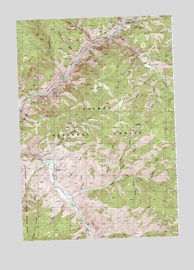
Pine Creek Rapids, ID USGS Topographic Map
Click on map above to begin viewing in our Map Viewer.

This topographic map contains these locations and features:
Feature Name Type Latitude Longitude GNIS ID View Map
Beaver CreekStreamN45.2735°W114.3356°377242View Map
Big Lead MineMineN45.3555°W114.2745°377561View Map
Big Sheepeater CreekStreamN45.3427°W114.3368°377585View Map
Birch CreekStreamN45.2569°W114.3218°377656View Map
Clear CreekStreamN45.2952°W114.3515°379398View Map
Clear Creek Recreation SiteLocaleN45.2880°W114.3504°376190View Map
Clipper Bullion MineMineN45.3688°W114.2776°396307View Map
Cohen GulchValleyN45.3519°W114.3279°379497View Map
Copper CanyonValleyN45.2838°W114.2973°379696View Map
Copper King MineMineN45.3096°W114.2820°379717View Map
Copper MountainSummitN45.3141°W114.2773°379722View Map
Copper Mountain TrailTrailN45.3355°W114.3037°379724View Map
Dry GulchValleyN45.2980°W114.3623°380878View Map
Dry Wash GulchValleyN45.2774°W114.3270°380901View Map
Dutch Oven CreekStreamN45.3310°W114.3656°380963View Map
Dutch Oven RapidsRapidsN45.3311°W114.3658°376435View Map
Eagles NestSummitN45.3624°W114.2881°381002View Map
German GulchValleyN45.3441°W114.2676°382250View Map
Gold Hill MineMineN45.3699°W114.2870°382384View Map
Grunter MineMineN45.3735°W114.2893°382765View Map
Halfway GulchValleyN45.3396°W114.3387°382817View Map
Hot SpringsSpringN45.3069°W114.3390°377490View Map
Hot Springs CreekStreamN45.2974°W114.3581°399923View Map
Hot Springs LookoutLocaleN45.3196°W114.3529°383455View Map
Hot Springs Trail (historical)TrailN45.3013°W114.3440°383457View Map
Kentuck MineMineN45.3713°W114.2976°384177View Map
Little Sheepeater CreekStreamN45.3608°W114.3134°384945View Map
Mayflower GulchValleyN45.2841°W114.2876°386559View Map
Mayflower MineMineN45.2833°W114.2851°386561View Map
Pine CreekStreamN45.3638°W114.3001°388497View Map
Pine Creek Ranch (historical)LocaleN45.3424°W114.2615°388505View Map
Pine Creek RapidsRapidsN45.3614°W114.3064°388506View Map
Reservoir GulchValleyN45.2819°W114.3045°389313View Map
Rood GulchValleyN45.2716°W114.3362°389587View Map
Rood Ranch (historical)LocaleN45.2724°W114.3348°389588View Map
Sawlog GulchValleyN45.2835°W114.2973°398097View Map
Sawmill GulchValleyN45.3466°W114.2709°389980View Map
Smith GulchValleyN45.3391°W114.2598°390690View Map
Trail CreekStreamN45.2505°W114.3193°392311View Map
Wagon Road GulchValleyN45.2821°W114.2745°392764View Map
Wire GulchValleyN45.2824°W114.3448°393604View Map

Note: Coordinates in the location and feature list above are referenced to NAD83 datum.


Copyright (C) 2008-2024 Ryan Niemi / Sunset Dynamics ... All Rights Reserved