TopoQuest Logo
Do you find TopoQuest useful?
Help keep TopoQuest running and adding new maps/features by donating!
Bitcoin:  19c7KJd3qBynnjoSw5npx9KScwjBe4ifkT
Litecoin:  LXs6TkuXGGXo1vDsWCkWVdjQX94eUKd6ui
Home View Maps Find Maps Find Places Resources & Links


Ulysses, Idaho Topographic Map

USGS Map Title: Ulysses, ID
USGS Map MRC: 45114D2
DRG (GeoTIFF) Download: o45114d2.tif


Neighboring USGS Topographic Map Quads:


  Alta, MT  
45114E3
 

  Henderson Ridge, ID  
45114E2
 

  Allan Mountain, ID  
45114E1
 

  Shoup, ID  
45114D3
 

  Ulysses, ID  
45114D2
 

  Ulysses Mountain, ID  
45114D1
 

  Pine Creek Rapids, ID  
45114C3
 

  Pine Creek Ridge, ID  
45114C2
 

  Napoleon Hill, ID  
45114C1


Map MRC Location:

N46°
W115°
N46°
W114°
H8 H7 H6 H5 H4 H3 H2 H1
G8 G7 G6 G5 G4 G3 G2 G1
F8 F7 F6 F5 F4 F3 F2 F1
E8 E7 E6 E5 E4 E3 E2 E1
D8 D7 D6 D5 D4 D3 D2 D1
C8 C7 C6 C5 C4 C3 C2 C1
B8 B7 B6 B5 B4 B3 B2 B1
A8 A7 A6 A5 A4 A3 A2 A1
N45°
W115°
N45°
W114°

Ulysses, ID USGS 1:24K Topographic Map Preview:
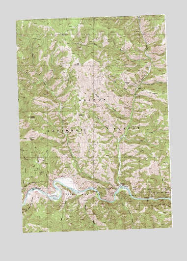
Ulysses, ID USGS Topographic Map
Click on map above to begin viewing in our Map Viewer.

This topographic map contains these locations and features:
Feature Name Type Latitude Longitude GNIS ID View Map
Bald MountainSummitN45.4727°W114.1987°376885View Map
Brushy GulchValleyN45.4410°W114.1584°378343View Map
Cabin CreekStreamN45.4305°W114.1634°378653View Map
Corral CreekStreamN45.4983°W114.1487°379798View Map
Cow GulchValleyN45.4274°W114.1687°379969View Map
Coyote SpringSpringN45.4431°W114.1967°376197View Map
Crystal GulchValleyN45.4158°W114.1679°380123View Map
Dutchler BasinBasinN45.4271°W114.2398°400477View Map
Dutchler MountainSummitN45.4430°W114.2409°380965View Map
East Boulder CreekStreamN45.3958°W114.1715°381020View Map
East Fork Indian CreekStreamN45.4608°W114.1476°381118View Map
Hale GulchValleyN45.3988°W114.2076°382806View Map
Indian CreekStreamN45.4002°W114.1690°383660View Map
Indian Creek Guest RanchLocaleN45.4588°W114.1515°399734View Map
Indianola Field StationLocaleN45.4013°W114.1676°383723View Map
Kitty Burton MineMineN45.4599°W114.1598°384269View Map
Kitty GulchValleyN45.4541°W114.1551°384270View Map
Little Sage CreekStreamN45.3930°W114.1323°384932View Map
Little Spring CreekStreamN45.3977°W114.2462°384963View Map
Papoose CreekStreamN45.4110°W114.2006°388153View Map
Porcupine SpringSpringN45.4903°W114.2118°388772View Map
Sawlog GulchValleyN45.3977°W114.1879°398098View Map
Squaw CreekStreamN45.3991°W114.1701°391295View Map
Transfer GulchValleyN45.3985°W114.2295°392331View Map
Ulysses (historical)Populated PlaceN45.4577°W114.1515°398290View Map
Ulysses MineMineN45.4530°W114.1398°392600View Map
West Fork Indian CreekStreamN45.4752°W114.1415°393124View Map
West Fork Squaw CreekStreamN45.4638°W114.2295°393204View Map

Note: Coordinates in the location and feature list above are referenced to NAD83 datum.


Copyright (C) 2008-2025 Ryan Niemi / Sunset Dynamics ... All Rights Reserved