TopoQuest Logo
Do you find TopoQuest useful?
Help keep TopoQuest running and adding new maps/features by donating!
Bitcoin:  19c7KJd3qBynnjoSw5npx9KScwjBe4ifkT
Litecoin:  LXs6TkuXGGXo1vDsWCkWVdjQX94eUKd6ui
Home View Maps Find Maps Find Places Resources & Links


Pine Prairie, Texas Topographic Map

USGS Map Title: Pine Prairie, TX
USGS Map MRC: 30095G5
DRG (GeoTIFF) Download: o30095g5.tif


Neighboring USGS Topographic Map Quads:


  Baker Lake, TX  
30095H6
 

  Wyser Bottom, TX  
30095H5
 

  Trinity West, TX  
30095H4
 

  Crabbs Prairie, TX  
30095G6
 

  Pine Prairie, TX  
30095G5
 

  Riverside, TX  
30095G4
 

  Galilee, TX  
30095F6
 

  Huntsville, TX  
30095F5
 

  Phelps, TX  
30095F4


Map MRC Location:

N31°
W96°
N31°
W95°
H8 H7 H6 H5 H4 H3 H2 H1
G8 G7 G6 G5 G4 G3 G2 G1
F8 F7 F6 F5 F4 F3 F2 F1
E8 E7 E6 E5 E4 E3 E2 E1
D8 D7 D6 D5 D4 D3 D2 D1
C8 C7 C6 C5 C4 C3 C2 C1
B8 B7 B6 B5 B4 B3 B2 B1
A8 A7 A6 A5 A4 A3 A2 A1
N30°
W96°
N30°
W95°

Pine Prairie, TX USGS 1:24K Topographic Map Preview:
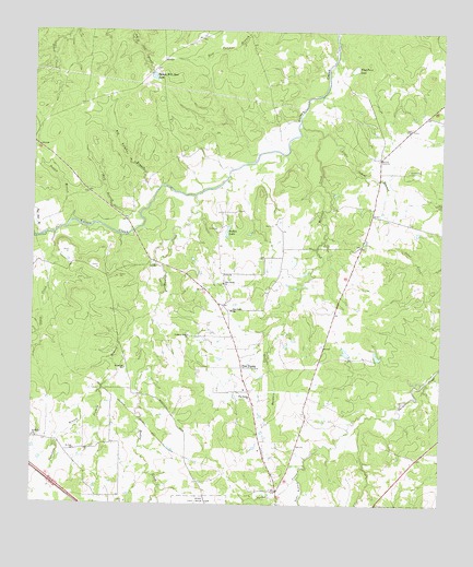
Pine Prairie, TX USGS Topographic Map
Click on map above to begin viewing in our Map Viewer.

This topographic map contains these locations and features:
Feature Name Type Latitude Longitude GNIS ID View Map
Baldwin CreekStreamN30.8513°W95.5441°1383022View Map
Big Sulphur BranchStreamN30.8335°W95.5872°1383030View Map
Cline Prairie CemeteryCemeteryN30.8388°W95.5102°1383064View Map
Crabb CreekStreamN30.8216°W95.6183°1383073View Map
Easam Mill Seat LakeReservoirN30.8628°W95.5887°1383085View Map
Easam Mill Seat Lake DamDamN30.8635°W95.5902°1860105View Map
Flag Point LakeLakeN30.8654°W95.5272°1383092View Map
Gibbs Brothers LakeReservoirN30.8545°W95.5680°1860108View Map
Gibbs Brothers Lake DamDamN30.8535°W95.5669°1860107View Map
Hadley CreekStreamN30.8316°W95.5758°1383100View Map
Harmony Grove ChurchChurchN30.7949°W95.5766°1383103View Map
Little School BranchStreamN30.8477°W95.5366°1383127View Map
Pine PrairiePopulated PlaceN30.7863°W95.5599°1383152View Map
Pine Prairie ChurchChurchN30.7785°W95.5577°1383153View Map
Pine Prairie ChurchChurchN30.8085°W95.5669°1383154View Map
Pine Prairie SchoolSchoolN30.8013°W95.5644°1383155View Map
Pine Prairie Volunteer Fire DepartmentBuildingN30.8033°W95.5667°2655352View Map
Possum BranchStreamN30.8249°W95.6127°1383159View Map
Post Oak BranchStreamN30.8207°W95.6219°1383161View Map
Raven's Nest AirportAirportN30.8011°W95.5423°2770208View Map
Rosenwall SchoolSchoolN30.7860°W95.5961°1383169View Map
Saint Marks ChurchChurchN30.7680°W95.6241°1383172View Map
Saint Paul ChurchChurchN30.7646°W95.6116°1383175View Map
Sixmile BranchStreamN30.8013°W95.5869°1383184View Map
Sudan LakeReservoirN30.8224°W95.5658°1383194View Map
Thompson CreekStreamN30.7799°W95.6041°1383198View Map
Town BranchStreamN30.7577°W95.5424°1383200View Map
Wolf BranchStreamN30.8269°W95.5919°1383216View Map

Note: Coordinates in the location and feature list above are referenced to NAD83 datum.


Copyright (C) 2008-2024 Ryan Niemi / Sunset Dynamics ... All Rights Reserved