TopoQuest Logo
Do you find TopoQuest useful?
Help keep TopoQuest running and adding new maps/features by donating!
Bitcoin:  19c7KJd3qBynnjoSw5npx9KScwjBe4ifkT
Litecoin:  LXs6TkuXGGXo1vDsWCkWVdjQX94eUKd6ui
Home View Maps Find Maps Find Places Resources & Links


Riverside, Texas Topographic Map

USGS Map Title: Riverside, TX
USGS Map MRC: 30095G4
DRG (GeoTIFF) Download: o30095g4.tif


Neighboring USGS Topographic Map Quads:


  Wyser Bottom, TX  
30095H5
 

  Trinity West, TX  
30095H4
 

  Trinity East, TX  
30095H3
 

  Pine Prairie, TX  
30095G5
 

  Riverside, TX  
30095G4
 

  Staley, TX  
30095G3
 

  Huntsville, TX  
30095F5
 

  Phelps, TX  
30095F4
 

  Oakhurst, TX  
30095F3


Map MRC Location:

N31°
W96°
N31°
W95°
H8 H7 H6 H5 H4 H3 H2 H1
G8 G7 G6 G5 G4 G3 G2 G1
F8 F7 F6 F5 F4 F3 F2 F1
E8 E7 E6 E5 E4 E3 E2 E1
D8 D7 D6 D5 D4 D3 D2 D1
C8 C7 C6 C5 C4 C3 C2 C1
B8 B7 B6 B5 B4 B3 B2 B1
A8 A7 A6 A5 A4 A3 A2 A1
N30°
W96°
N30°
W95°

Riverside, TX USGS 1:24K Topographic Map Preview:
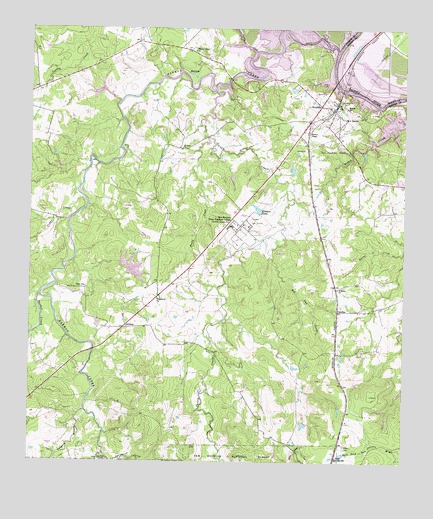
Riverside, TX USGS Topographic Map
Click on map above to begin viewing in our Map Viewer.

This topographic map contains these locations and features:
Feature Name Type Latitude Longitude GNIS ID View Map
ArizonaPopulated PlaceN30.7896°W95.4680°1383020View Map
Broyles ChurchChurchN30.8524°W95.3949°1383045View Map
Camp AliceLocaleN30.8005°W95.4813°1383051View Map
Campus LakeReservoirN30.8232°W95.4244°1383052View Map
Caney CreekStreamN30.8574°W95.4391°1383057View Map
CarolinaPopulated PlaceN30.7938°W95.3969°1383058View Map
Cedar CreekStreamN30.8263°W95.4824°1383060View Map
City of RiversideCivilN30.8473°W95.3982°2410966View Map
Dodge CemeteryCemeteryN30.7549°W95.3944°1383077View Map
Dodge Junior High SchoolSchoolN30.7513°W95.3969°1383078View Map
Harmon CreekStreamN30.8691°W95.3983°1383102View Map
Holmes ChapelChurchN30.8449°W95.4080°1383108View Map
Horseshoe Lake Number 1 DamDamN30.8069°W95.4702°1860133View Map
Horseshoe Lake Number 2ReservoirN30.8057°W95.4652°1862894View Map
Horseshoe Lake Number 2 DamDamN30.8069°W95.4669°1862893View Map
Lake ForestReservoirN30.8585°W95.4202°1860132View Map
Lake Forest DamDamN30.8585°W95.4202°1860131View Map
Mud LakeLakeN30.8619°W95.4459°1383137View Map
Parker CreekStreamN30.7980°W95.4966°1383147View Map
Pilgrim Ridge ChurchChurchN30.8685°W95.4458°1383150View Map
Red Oak CreekStreamN30.8132°W95.4177°1383163View Map
RiversidePopulated PlaceN30.8530°W95.4036°1383164View Map
Riverside DivisionCivilN30.8554°W95.4838°1939132View Map
Riverside Post OfficePost OfficeN30.8535°W95.4023°2731365View Map
Riverside Swinging BridgeBridgeN30.8574°W95.3963°2030675View Map
Riverside Volunteer Fire DepartmentBuildingN30.8520°W95.4006°2655330View Map
Rocky CreekStreamN30.8438°W95.4411°1383166View Map
Saint Marys ChurchChurchN30.8002°W95.3969°1383173View Map
Saint Olive ChurchChurchN30.8405°W95.4497°1383174View Map
Sam Houston State Teachers CollegeSchoolN30.8188°W95.4333°1383176View Map
Spring CreekStreamN30.7502°W95.4724°1383192View Map
Styles Lake 1ReservoirN30.8079°W95.4688°1860134View Map
Tan Yard BranchStreamN30.7649°W95.4813°1383015View Map
Thessalonto ChurchChurchN30.7971°W95.4577°1383197View Map
Turkey CreekStreamN30.8685°W95.4252°1383202View Map
Walker County Constable's Office Precinct 3BuildingN30.8005°W95.4528°2751544View Map

Note: Coordinates in the location and feature list above are referenced to NAD83 datum.


Copyright (C) 2008-2025 Ryan Niemi / Sunset Dynamics ... All Rights Reserved