TopoQuest Logo
Do you find TopoQuest useful?
Help keep TopoQuest running and adding new maps/features by donating!
Bitcoin:  19c7KJd3qBynnjoSw5npx9KScwjBe4ifkT
Litecoin:  LXs6TkuXGGXo1vDsWCkWVdjQX94eUKd6ui
Home View Maps Find Maps Find Places Resources & Links


Wyser Bottom, Texas Topographic Map

USGS Map Title: Wyser Bottom, TX
USGS Map MRC: 30095H5
DRG (GeoTIFF) Download: o30095h5.tif


Neighboring USGS Topographic Map Quads:


  Sand Ridge, TX  
31095A6
 

  Weldon, TX  
31095A5
 

  Lovelady South, TX  
31095A4
 

  Baker Lake, TX  
30095H6
 

  Wyser Bottom, TX  
30095H5
 

  Trinity West, TX  
30095H4
 

  Crabbs Prairie, TX  
30095G6
 

  Pine Prairie, TX  
30095G5
 

  Riverside, TX  
30095G4


Map MRC Location:

N31°
W96°
N31°
W95°
H8 H7 H6 H5 H4 H3 H2 H1
G8 G7 G6 G5 G4 G3 G2 G1
F8 F7 F6 F5 F4 F3 F2 F1
E8 E7 E6 E5 E4 E3 E2 E1
D8 D7 D6 D5 D4 D3 D2 D1
C8 C7 C6 C5 C4 C3 C2 C1
B8 B7 B6 B5 B4 B3 B2 B1
A8 A7 A6 A5 A4 A3 A2 A1
N30°
W96°
N30°
W95°

Wyser Bottom, TX USGS 1:24K Topographic Map Preview:
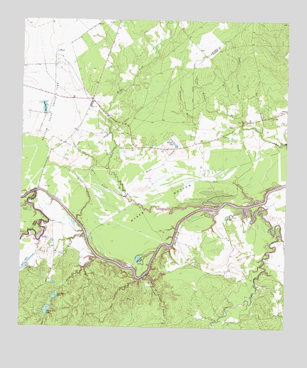
Wyser Bottom, TX USGS Topographic Map
Click on map above to begin viewing in our Map Viewer.

This topographic map contains these locations and features:
Feature Name Type Latitude Longitude GNIS ID View Map
Bear BranchStreamN30.9269°W95.5124°1351656View Map
Bedias CreekStreamN30.9302°W95.6183°1372467View Map
Big Tucker LakeLakeN30.9204°W95.5278°1352171View Map
Black CreekStreamN30.9038°W95.5886°1383469View Map
Black CreekStreamN30.9032°W95.5891°1372601View Map
Calhoun CemeteryCemeteryN30.9046°W95.6047°1353545View Map
Calhoun Ferry (historical)CrossingN30.9310°W95.6172°1377279View Map
Cincinnati BluffCliffN30.9116°W95.5516°1354498View Map
Cincinnati CemeteryCemeteryN30.9035°W95.5452°1354499View Map
Dunlap CemeteryCemeteryN30.9591°W95.5011°1356461View Map
East Sulphur BranchStreamN30.8957°W95.5666°1373568View Map
East Sulphur BranchStreamN30.8832°W95.5666°1383467View Map
Eve BranchStreamN30.9552°W95.5127°1357111View Map
Garden LakeReservoirN30.9644°W95.6146°1357873View Map
Garden Lake DamDamN30.9619°W95.6136°1860735View Map
Graveyard CreekStreamN30.9124°W95.5949°1358341View Map
Green PondLakeN30.9221°W95.6216°1358383View Map
Harper BranchStreamN30.9305°W95.5761°1358822View Map
Horseshoe LakeLakeN30.9026°W95.5685°1359652View Map
Indian Hill LakeReservoirN30.8816°W95.6127°1359955View Map
Indian Hill Lake DamDamN30.8835°W95.6102°1860125View Map
Jenkins BranchStreamN30.9613°W95.5227°1360208View Map
Little Tucker LakeLakeN30.8764°W95.5287°1361491View Map
Lost Indian CampLocaleN30.8985°W95.6216°1361824View Map
Lost Indian LakeReservoirN30.8877°W95.6087°1361825View Map
Lost Indian Lake DamDamN30.8902°W95.6086°1860123View Map
Mason CemeteryCemeteryN30.9430°W95.6030°1362255View Map
Mason SloughStreamN30.9188°W95.5991°1362260View Map
Melton BranchStreamN30.9282°W95.5758°1362592View Map
Moten LakeReservoirN30.9019°W95.6186°1860128View Map
Moten LakeLakeN30.8987°W95.6238°1375019View Map
Moten Lake DamDamN30.9019°W95.6186°1860127View Map
Nelson CreekStreamN30.9244°W95.5205°1383430View Map
Nelson CreekStreamN30.9244°W95.5199°1375110View Map
New Hope ChurchChurchN30.9605°W95.5074°1363732View Map
Old Plantation Cemetery (historical)CemeteryN30.9680°W95.6094°1377280View Map
Polecat BranchStreamN30.9644°W95.5388°1365527View Map
Rocky Ford ChurchChurchN30.9585°W95.5202°1366782View Map
Spivey CemeteryCemeteryN30.9569°W95.5258°1368914View Map
Thompson BranchStreamN30.9644°W95.5386°1369847View Map
Waller LakeReservoirN30.9504°W95.5535°1370794View Map
West Sulphur BranchStreamN30.8946°W95.5691°1376726View Map
White Oak CreekStreamN30.8974°W95.5947°1383470View Map
White Oak CreekStreamN30.8988°W95.5941°1376752View Map
Woods SloughStreamN30.9180°W95.6152°1371932View Map
Wright CreekStreamN30.9241°W95.5391°1371975View Map
Wyser BluffCliffN30.8982°W95.5636°1371990View Map
Wyser BottomBendN30.9263°W95.5591°1371991View Map

Note: Coordinates in the location and feature list above are referenced to NAD83 datum.


Copyright (C) 2008-2025 Ryan Niemi / Sunset Dynamics ... All Rights Reserved