TopoQuest Logo
Do you find TopoQuest useful?
Help keep TopoQuest running and adding new maps/features by donating!
Bitcoin:  19c7KJd3qBynnjoSw5npx9KScwjBe4ifkT
Litecoin:  LXs6TkuXGGXo1vDsWCkWVdjQX94eUKd6ui
Home View Maps Find Maps Find Places Resources & Links


Bethel, Vermont Topographic Map

USGS Map Title: Bethel, VT
USGS Map MRC: 43072G6
DRG (GeoTIFF) Download: o43072g6.tif


Neighboring USGS Topographic Map Quads:


  Hancock, VT  
43072H7
 

  Randolph, VT  
43072H6
 

  Randolph Center, VT  
43072H5
 

  Rochester, VT  
43072G7
 

  Bethel, VT  
43072G6
 

  South Royalton, VT  
43072G5
 

  Pico Peak, VT  
43072F7
 

  Delectable Mountain, VT  
43072F6
 

  Woodstock North, VT  
43072F5


Map MRC Location:

N44°
W73°
N44°
W72°
H8 H7 H6 H5 H4 H3 H2 H1
G8 G7 G6 G5 G4 G3 G2 G1
F8 F7 F6 F5 F4 F3 F2 F1
E8 E7 E6 E5 E4 E3 E2 E1
D8 D7 D6 D5 D4 D3 D2 D1
C8 C7 C6 C5 C4 C3 C2 C1
B8 B7 B6 B5 B4 B3 B2 B1
A8 A7 A6 A5 A4 A3 A2 A1
N43°
W73°
N43°
W72°

Bethel, VT USGS 1:24K Topographic Map Preview:
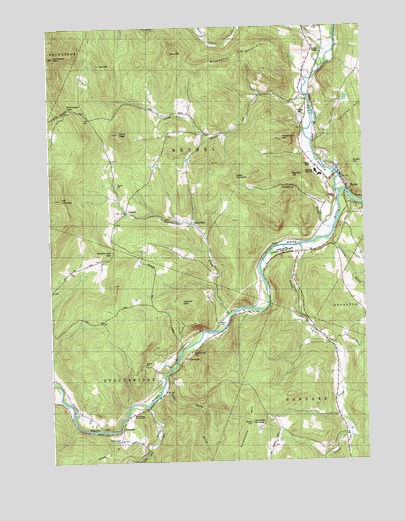
Bethel, VT USGS Topographic Map
Click on map above to begin viewing in our Map Viewer.

This topographic map contains these locations and features:
Feature Name Type Latitude Longitude GNIS ID View Map
Abbott CemeteryCemeteryN43.7899°W72.6831°1922221View Map
BethelPopulated PlaceN43.8334°W72.6340°1456402View Map
Bethel Census Designated PlaceCensusN43.8311°W72.6365°2586620View Map
Bethel Elementary SchoolSchoolN43.8331°W72.6435°1922255View Map
Bethel Fire DepartmentBuildingN43.8360°W72.6463°2121313View Map
Bethel Mills DamDamN43.8334°W72.6329°1766629View Map
Bethel Post OfficePost OfficeN43.8333°W72.6345°1922256View Map
Bethel Town ForestForestN43.8612°W72.6920°1922257View Map
Bethel Village Historic DistrictParkN43.8326°W72.6343°1922258View Map
Blueberry MountainSummitN43.8684°W72.6729°1456498View Map
Camp BrookPopulated PlaceN43.8503°W72.6932°1456727View Map
Camp BrookStreamN43.8540°W72.6462°1456728View Map
Cleveland BrookStreamN43.8148°W72.6379°1456917View Map
Cowdrey OutlookSummitN43.7612°W72.6707°1457034View Map
Delectable MountainSummitN43.7609°W72.6712°1457144View Map
Fairview CemeteryCemeteryN43.8486°W72.6486°1457401View Map
Flynn SchoolSchoolN43.8540°W72.6526°1457464View Map
GaysvillePopulated PlaceN43.7784°W72.6990°1457531View Map
Gaysville Post OfficePost OfficeN43.7779°W72.6999°1922373View Map
Gilead BrookStreamN43.8667°W72.6379°1460899View Map
Gilead Brook Covered BridgeBridgeN43.8737°W72.6473°1922376View Map
Gilead CemeteryCemeteryN43.8729°W72.6871°1922377View Map
Heap PinnaclePillarN43.8331°W72.6765°1457785View Map
Lee HillSummitN43.8656°W72.7284°1458186View Map
LilliesvillePopulated PlaceN43.8195°W72.6940°1458207View Map
Lilliesville BrookStreamN43.7931°W72.6795°1458208View Map
Little Stony BrookStreamN43.7712°W72.7068°1458255View Map
Locust CreekStreamN43.8131°W72.6482°1458259View Map
Locust Creek SchoolSchoolN43.7723°W72.6359°1458260View Map
LympusPopulated PlaceN43.8223°W72.7190°1458842View Map
Lympus CemeteryCemeteryN43.8142°W72.7253°1922453View Map
Mount LympusSummitN43.8258°W72.7454°1458581View Map
Mount Pleasant CemeteryCemeteryN43.7554°W72.7230°1461858View Map
Naught HillSummitN43.8342°W72.6532°1458653View Map
Oak HillSummitN43.8678°W72.6987°1458808View Map
Old Church CemeteryCemeteryN43.8749°W72.6470°1922506View Map
Pauls PeakSummitN43.8456°W72.7212°1458911View Map
Pond BrookStreamN43.7606°W72.6304°1459033View Map
Randall Drive-InLocaleN43.8689°W72.6425°2633589View Map
RiversidePopulated PlaceN43.7592°W72.7234°1459198View Map
Rochester GapGapN43.8523°W72.7412°1459226View Map
Rochester MountainSummitN43.8667°W72.7476°1459227View Map
Rood State ParkParkN43.8106°W72.6607°1459244View Map
Shaw HillSummitN43.8340°W72.6273°1459466View Map
Stockbridge Central SchoolSchoolN43.7643°W72.7180°1922625View Map
Stockbridge GapGapN43.8103°W72.7254°1459724View Map
Stoddard BrookStreamN43.8159°W72.6379°1459726View Map
Stony BrookStreamN43.7667°W72.7126°1459734View Map
Sylvester Plot CemeteryCemeteryN43.7812°W72.6940°1922642View Map
Third Branch White RiverStreamN43.8281°W72.6329°1461539View Map
Town of BethelCivilN43.8503°W72.6729°1462043View Map
Town of StockbridgeCivilN43.7563°W72.7442°1462218View Map
Vulture MountainSummitN43.7959°W72.6970°1460031View Map
West BethelPopulated PlaceN43.8501°W72.6940°1922702View Map
Whitcomb Junior / Senior High SchoolSchoolN43.8332°W72.6435°1460214View Map
White River National Fish HatcheryParkN43.8101°W72.6583°1922727View Map
White River Valley AmbulanceBuildingN43.8709°W72.6451°2578080View Map
White River Valley Camping AreaLocaleN43.7773°W72.6984°1922728View Map
Woodbury HillSummitN43.8431°W72.6576°1460310View Map

Note: Coordinates in the location and feature list above are referenced to NAD83 datum.


Copyright (C) 2008-2025 Ryan Niemi / Sunset Dynamics ... All Rights Reserved