TopoQuest Logo
Do you find TopoQuest useful?
Help keep TopoQuest running and adding new maps/features by donating!
Bitcoin:  19c7KJd3qBynnjoSw5npx9KScwjBe4ifkT
Litecoin:  LXs6TkuXGGXo1vDsWCkWVdjQX94eUKd6ui
Home View Maps Find Maps Find Places Resources & Links


South Royalton, Vermont Topographic Map

USGS Map Title: South Royalton, VT
USGS Map MRC: 43072G5
DRG (GeoTIFF) Download: o43072g5.tif


Neighboring USGS Topographic Map Quads:


  Randolph, VT  
43072H6
 

  Randolph Center, VT  
43072H5
 

  Chelsea, VT  
43072H4
 

  Bethel, VT  
43072G6
 

  South Royalton, VT  
43072G5
 

  Sharon, VT  
43072G4
 

  Delectable Mountain, VT  
43072F6
 

  Woodstock North, VT  
43072F5
 

  Quechee, VT  
43072F4


Map MRC Location:

N44°
W73°
N44°
W72°
H8 H7 H6 H5 H4 H3 H2 H1
G8 G7 G6 G5 G4 G3 G2 G1
F8 F7 F6 F5 F4 F3 F2 F1
E8 E7 E6 E5 E4 E3 E2 E1
D8 D7 D6 D5 D4 D3 D2 D1
C8 C7 C6 C5 C4 C3 C2 C1
B8 B7 B6 B5 B4 B3 B2 B1
A8 A7 A6 A5 A4 A3 A2 A1
N43°
W73°
N43°
W72°

South Royalton, VT USGS 1:24K Topographic Map Preview:
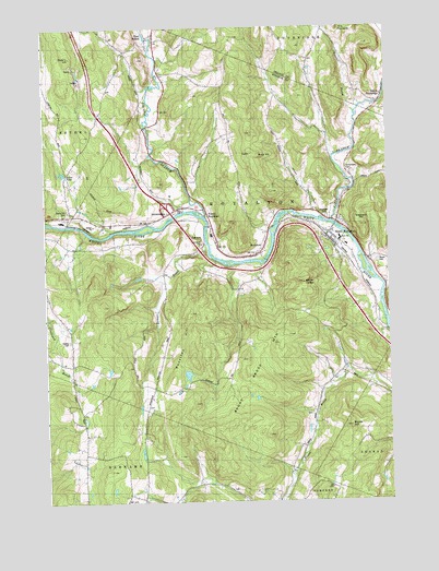
South Royalton, VT USGS Topographic Map
Click on map above to begin viewing in our Map Viewer.

This topographic map contains these locations and features:
Feature Name Type Latitude Longitude GNIS ID View Map
Ansel PondLakeN43.8368°W72.6179°1456166View Map
Ashley - Ellis CemeteryCemeteryN43.7522°W72.5411°1922342View Map
Boyds HillSummitN43.7706°W72.5143°1456535View Map
Branchview CemeteryCemeteryN43.8360°W72.5142°1456554View Map
Broad Brook CemeteryCemeteryN43.7729°W72.5290°1922282View Map
Broad Brook MountainSummitN43.7834°W72.5512°1456577View Map
Cherry Hill CemeteryCemeteryN43.8267°W72.6162°1456869View Map
Christian HillSummitN43.8590°W72.6165°1456887View Map
East BethelPopulated PlaceN43.8734°W72.5843°1457252View Map
East Bethel CemeteryCemeteryN43.8717°W72.5842°1922338View Map
Elephant HillSummitN43.8231°W72.5093°1457351View Map
First Branch White RiverStreamN43.8248°W72.5201°1457431View Map
Happy HollowValleyN43.8256°W72.5254°1457720View Map
Haven CemeteryCemeteryN43.8131°W72.5037°1457761View Map
Hickey CemeteryCemeteryN43.7927°W72.6162°1457812View Map
Interchange 3CrossingN43.8273°W72.5809°1922417View Map
Julian and Virginia Cornell LibraryBuildingN43.8215°W72.5212°1922430View Map
Kents LedgeBenchN43.8073°W72.5293°1458074View Map
Lone Oak FarmLocaleN43.8467°W72.5883°2680830View Map
North Road - Methodist CemeteryCemeteryN43.7675°W72.6105°1922486View Map
North RoyaltonPopulated PlaceN43.8273°W72.5665°1458757View Map
North Royalton CemeteryCemeteryN43.8201°W72.5632°1922487View Map
Pleasant Hill CemeteryCemeteryN43.8193°W72.5444°1922531View Map
Quarry HillSummitN43.8673°W72.6151°1459121View Map
Quarry Hill - Woodworth CemeteryCemeteryN43.8711°W72.5972°1922547View Map
RoyaltonPopulated PlaceN43.8159°W72.5457°1459277View Map
Royalton HillSummitN43.7870°W72.5695°1459278View Map
Russ HillSummitN43.8415°W72.5473°1459288View Map
Russell BrookStreamN43.8537°W72.5126°1459291View Map
Second Branch White RiverStreamN43.8245°W72.5670°1459442View Map
Sewall BrookStreamN43.8173°W72.5670°1459448View Map
South RoyaltonPopulated PlaceN43.8209°W72.5212°1459612View Map
South Royalton Census Designated PlaceCensusN43.8122°W72.5154°2586655View Map
South Royalton Fire DepartmentBuildingN43.8185°W72.5193°2121292View Map
South Royalton Post OfficePost OfficeN43.8197°W72.5219°1922634View Map
South Royalton SchoolSchoolN43.8193°W72.5173°1922635View Map
South Royalton Village CemeteryCemeteryN43.8182°W72.5167°1922636View Map
South TunbridgePopulated PlaceN43.8553°W72.5029°1459617View Map
Town of RoyaltonCivilN43.8147°W72.5520°1462191View Map
Vermont Law SchoolSchoolN43.8215°W72.5212°1922684View Map
Vermont State Police Troop B Royalton BarracksBuildingN43.8230°W72.6046°2752803View Map
Ward Hill CemeteryCemeteryN43.8689°W72.5371°1921610View Map

Note: Coordinates in the location and feature list above are referenced to NAD83 datum.


Copyright (C) 2008-2025 Ryan Niemi / Sunset Dynamics ... All Rights Reserved