TopoQuest Logo
Do you find TopoQuest useful?
Help keep TopoQuest running and adding new maps/features by donating!
Bitcoin:  19c7KJd3qBynnjoSw5npx9KScwjBe4ifkT
Litecoin:  LXs6TkuXGGXo1vDsWCkWVdjQX94eUKd6ui
Home View Maps Find Maps Find Places Resources & Links


Pinyon Mountain, Arizona Topographic Map

USGS Map Title: Pinyon Mountain, AZ
USGS Map MRC: 33111E2
DRG (GeoTIFF) Download: o33111e2.tif


Neighboring USGS Topographic Map Quads:


  Four Peaks, AZ  
33111F3
 

  Theodore Roosevelt Dam, AZ  
33111F2
 

  Windy Hill, AZ  
33111F1
 

  Horse Mesa Dam, AZ  
33111E3
 

  Pinyon Mountain, AZ  
33111E2
 

  Two Bar Mountain, AZ  
33111E1
 

  Weavers Needle, AZ  
33111D3
 

  Iron Mountain, AZ  
33111D2
 

  Haunted Canyon, AZ  
33111D1


Map MRC Location:

N34°
W112°
N34°
W111°
H8 H7 H6 H5 H4 H3 H2 H1
G8 G7 G6 G5 G4 G3 G2 G1
F8 F7 F6 F5 F4 F3 F2 F1
E8 E7 E6 E5 E4 E3 E2 E1
D8 D7 D6 D5 D4 D3 D2 D1
C8 C7 C6 C5 C4 C3 C2 C1
B8 B7 B6 B5 B4 B3 B2 B1
A8 A7 A6 A5 A4 A3 A2 A1
N33°
W112°
N33°
W111°

Pinyon Mountain, AZ USGS 1:24K Topographic Map Preview:
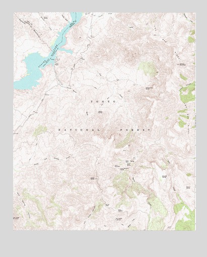
Pinyon Mountain, AZ USGS Topographic Map
Click on map above to begin viewing in our Map Viewer.

This topographic map contains these locations and features:
Feature Name Type Latitude Longitude GNIS ID View Map
Apache TrailTrailN33.5975°W111.2054°25726View Map
Bronco CreekStreamN33.6134°W111.2196°26767View Map
Bronco SpringSpringN33.6219°W111.2298°26768View Map
Burnt Corral CreekStreamN33.6237°W111.2035°27024View Map
Castle DomeSummitN33.5298°W111.1940°27345View Map
Cedar BasinBasinN33.5395°W111.1718°27394View Map
Cedar Basin SpringSpringN33.5400°W111.1690°36950View Map
Chukar WashStreamN33.6200°W111.2126°27627View Map
Davis SpringSpringN33.5787°W111.2073°36964View Map
Davis WashStreamN33.5942°W111.2229°28304View Map
Hidden SpringSpringN33.5713°W111.2011°40882View Map
Ike SpringSpringN33.5973°W111.1562°37005View Map
Klondike SpringSpringN33.5310°W111.1483°30795View Map
Lime MountainSummitN33.5370°W111.1807°30966View Map
Lime Mountain SpringSpringN33.5349°W111.1769°30967View Map
Lion SpringSpringN33.6165°W111.1708°37018View Map
Maple SpringSpringN33.5381°W111.1723°31499View Map
Mazatzal BayBayN33.5984°W111.2351°2045138View Map
Mud SpringSpringN33.5048°W111.2398°44995View Map
Muskhog TankReservoirN33.5867°W111.1726°37042View Map
Paradise SpringSpringN33.5023°W111.1790°37054View Map
Pine CreekStreamN33.6031°W111.2201°32922View Map
Pinyon MountainSummitN33.5950°W111.1368°33019View Map
Plow SaddleGapN33.5112°W111.1793°33062View Map
Plow Saddle SpringsSpringN33.5067°W111.1803°33063View Map
Rainy SpringSpringN33.5723°W111.2173°37062View Map
Reavis CreekStreamN33.5520°W111.1612°33559View Map
Reavis TrailheadLocaleN33.5567°W111.2265°2057452View Map
Two Bar RidgeRidgeN33.5952°W111.1365°35640View Map
Walnut SpringSpringN33.5248°W111.1317°35869View Map
Water Dog Recreational SiteParkN33.5978°W111.2204°37118View Map
White Rock SpringSpringN33.5967°W111.1793°37121View Map
Windy PassGapN33.5142°W111.1873°36310View Map
Winger SpringSpringN33.5679°W111.1919°36319View Map
Yellowjacket SpringSpringN33.5815°W111.1595°36473View Map

Note: Coordinates in the location and feature list above are referenced to NAD83 datum.


Copyright (C) 2008-2024 Ryan Niemi / Sunset Dynamics ... All Rights Reserved