TopoQuest Logo
Do you find TopoQuest useful?
Help keep TopoQuest running and adding new maps/features by donating!
Bitcoin:  19c7KJd3qBynnjoSw5npx9KScwjBe4ifkT
Litecoin:  LXs6TkuXGGXo1vDsWCkWVdjQX94eUKd6ui
Home View Maps Find Maps Find Places Resources & Links


Plain City, Ohio Topographic Map

USGS Map Title: Plain City, OH
USGS Map MRC: 40083A3
DRG (GeoTIFF) Download: o40083a3.tif


Neighboring USGS Topographic Map Quads:


  Milford Center, OH  
40083B4
 

  Marysville, OH  
40083B3
 

  Shawnee Hills, OH  
40083B2
 

  Plumwood, OH  
40083A4
 

  Plain City, OH  
40083A3
 

  Hilliard, OH  
40083A2
 

  London, OH  
39083H4
 

  West Jefferson, OH  
39083H3
 

  Galloway, OH  
39083H2


Map MRC Location:

N41°
W84°
N41°
W83°
H8 H7 H6 H5 H4 H3 H2 H1
G8 G7 G6 G5 G4 G3 G2 G1
F8 F7 F6 F5 F4 F3 F2 F1
E8 E7 E6 E5 E4 E3 E2 E1
D8 D7 D6 D5 D4 D3 D2 D1
C8 C7 C6 C5 C4 C3 C2 C1
B8 B7 B6 B5 B4 B3 B2 B1
A8 A7 A6 A5 A4 A3 A2 A1
N40°
W84°
N40°
W83°

Plain City, OH USGS 1:24K Topographic Map Preview:
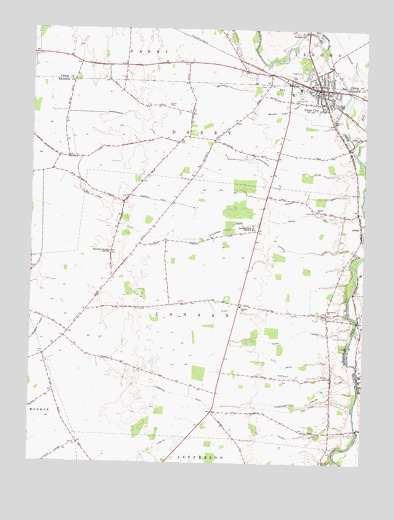
Plain City, OH USGS Topographic Map
Click on map above to begin viewing in our Map Viewer.

This topographic map contains these locations and features:
Feature Name Type Latitude Longitude GNIS ID View Map
AmityPopulated PlaceN40.0687°W83.2513°1077516View Map
Ballenger Jones DitchCanalN40.0678°W83.3005°1037603View Map
Beachys Airport (historical)AirportN40.0914°W83.3580°1082965View Map
Bidwell DitchCanalN40.0073°W83.2757°1037988View Map
Bidwell Elsey DitchCanalN40.1012°W83.2833°1037989View Map
Big Darby CemeteryCemeteryN40.0431°W83.2624°1068809View Map
Big Darby ChurchChurchN40.0428°W83.2635°1070683View Map
Bradley School (historical)SchoolN40.0317°W83.3552°1054084View Map
Canaan Community Mobile Home ParkPopulated PlaceN40.0156°W83.2647°2630800View Map
Canaan Elementary SchoolSchoolN40.0448°W83.2960°1081108View Map
Chandler DitchCanalN40.0251°W83.2735°1038980View Map
Converse CemeteryCemeteryN40.0365°W83.2610°1039326View Map
Converse School (historical)SchoolN40.0328°W83.2627°1054078View Map
Converse-Huff CemeteryCemeteryN40.0764°W83.3394°1068811View Map
Darby Township CemeteryCemeteryN40.0987°W83.2624°1068812View Map
Eli Jones DitchCanalN40.0737°W83.3458°1040113View Map
Ella Beach DitchCanalN40.0281°W83.2741°1040136View Map
Finch CemeteryCemeteryN40.0723°W83.2685°1040438View Map
Fitzgerald DitchCanalN40.0173°W83.2924°1040474View Map
Forest Grove CemeteryCemeteryN40.0940°W83.2527°1040556View Map
Heafey DitchCanalN40.0759°W83.2716°1041440View Map
Jonathan Alder High SchoolSchoolN40.0681°W83.2921°1042133View Map
Lombard School (historical)SchoolN40.0881°W83.3649°1054082View Map
Minoque School (historical)SchoolN40.0684°W83.3427°1054083View Map
Oak Grove School (historical)SchoolN40.0976°W83.3160°1054080View Map
Plain CityPopulated PlaceN40.1076°W83.2674°1061547View Map
Plain City Airport (historical)AirportN40.1081°W83.2741°1082962View Map
Plain City Elementary SchoolSchoolN40.1090°W83.2705°1067165View Map
Plain City Police DepartmentBuildingN40.1067°W83.2713°2732562View Map
Plain City Post OfficePost OfficeN40.1068°W83.2681°1084504View Map
Plain City Presbyterian ChurchChurchN40.1076°W83.2646°1068827View Map
Plain City Public LibraryBuildingN40.1081°W83.2696°1054077View Map
Plain City Town HallBuildingN40.1070°W83.2663°1084505View Map
Plain City United Methodist ChurchChurchN40.1092°W83.2680°1084332View Map
Plainview Christian Day SchoolSchoolN40.0606°W83.3452°1044518View Map
Pleasant Valley Joint Fire DistrictBuildingN40.1118°W83.2800°2549817View Map
Powell DitchCanalN40.0612°W83.2749°1044734View Map
Robinson RunStreamN40.1192°W83.2666°1066168View Map
Sacred Heart Catholic ChurchChurchN40.1037°W83.2666°1068831View Map
Saint Joseph Roman Catholic ChurchChurchN40.1037°W83.2669°1084506View Map
Sharon CemeteryCemeteryN40.0726°W83.2682°1068833View Map
Sharon ChurchChurchN40.0723°W83.2682°1070939View Map
Shekinah Airport (historical)AirportN40.0878°W83.3171°1082250View Map
Smith CemeteryCemeteryN40.1032°W83.3239°1046364View Map
Smith Cemetery PrairieAreaN40.1031°W83.3241°1054081View Map
Sugar RunStreamN40.0890°W83.2535°1046830View Map
Sweeney RunStreamN40.1034°W83.2591°1046901View Map
Syphrit Mobile Home ParkPopulated PlaceN40.1050°W83.2631°2630807View Map
Three Mile CreekStreamN40.0167°W83.2532°1065740View Map
Tolles Technical CenterSchoolN40.0540°W83.2910°1071027View Map
Township of CanaanCivilN40.0462°W83.3006°1086540View Map
Township of DarbyCivilN40.0918°W83.3022°1086541View Map
Triple D FarmsLocaleN40.0262°W83.3663°2730004View Map
Troyer Mobile Home ParkPopulated PlaceN40.1094°W83.2758°2630810View Map
United Bethel CemeteryCemeteryN40.1087°W83.2874°1068839View Map
Village of Plain CityCivilN40.1067°W83.2694°2399682View Map
Wilson DitchCanalN40.0365°W83.2769°1047983View Map
Wilson School (historical)SchoolN40.0190°W83.3052°1054079View Map
Worthington DitchCanalN40.0873°W83.2952°1048146View Map
Yutzy DitchCanalN40.0437°W83.2999°1048219View Map

Note: Coordinates in the location and feature list above are referenced to NAD83 datum.


Copyright (C) 2008-2025 Ryan Niemi / Sunset Dynamics ... All Rights Reserved