TopoQuest Logo
Do you find TopoQuest useful?
Help keep TopoQuest running and adding new maps/features by donating!
Bitcoin:  19c7KJd3qBynnjoSw5npx9KScwjBe4ifkT
Litecoin:  LXs6TkuXGGXo1vDsWCkWVdjQX94eUKd6ui
Home View Maps Find Maps Find Places Resources & Links


Bethune NW, South Carolina Topographic Map

USGS Map Title: Bethune NW, SC
USGS Map MRC: 34080D4
DRG (GeoTIFF) Download: o34080d4.tif


Neighboring USGS Topographic Map Quads:


  Kershaw, SC  
34080E5
 

  Mount Pisgah, SC  
34080E4
 

  Angelus, SC  
34080E3
 

  Westville, SC  
34080D5
 

  Bethune NW, SC  
34080D4
 

  Bethune, SC  
34080D3
 

  Camden North, SC  
34080C5
 

  Cassatt, SC  
34080C4
 

  Lucknow, SC  
34080C3


Map MRC Location:

N35°
W81°
N35°
W80°
H8 H7 H6 H5 H4 H3 H2 H1
G8 G7 G6 G5 G4 G3 G2 G1
F8 F7 F6 F5 F4 F3 F2 F1
E8 E7 E6 E5 E4 E3 E2 E1
D8 D7 D6 D5 D4 D3 D2 D1
C8 C7 C6 C5 C4 C3 C2 C1
B8 B7 B6 B5 B4 B3 B2 B1
A8 A7 A6 A5 A4 A3 A2 A1
N34°
W81°
N34°
W80°

Bethune NW, SC USGS 1:24K Topographic Map Preview:
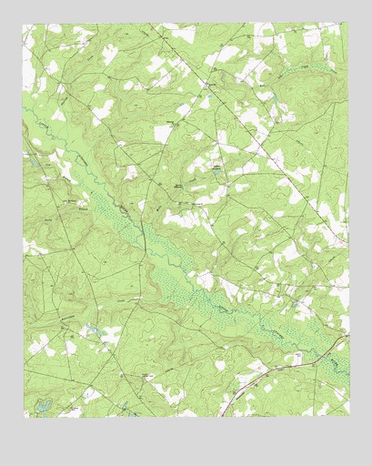
Bethune NW, SC USGS Topographic Map
Click on map above to begin viewing in our Map Viewer.

This topographic map contains these locations and features:
Feature Name Type Latitude Longitude GNIS ID View Map
Bakers MillpondLakeN34.4528°W80.4251°1244951View Map
Beaverdam CreekStreamN34.4121°W80.4287°1220445View Map
Bethel Hill ChurchChurchN34.4804°W80.4292°1246804View Map
Bethune DivisionCivilN34.4177°W80.3786°1938199View Map
Cassatt Lookout TowerTowerN34.3879°W80.4542°1242366View Map
Cow BranchStreamN34.4521°W80.4745°1221790View Map
DuBose CemeteryCemeteryN34.3782°W80.4820°1222123View Map
Gates Hill Community House (historical)BuildingN34.4174°W80.4012°1235089View Map
Gully BranchStreamN34.4390°W80.4598°1222938View Map
Kershaw County Fire Department Gates FordBuildingN34.4984°W80.4488°2578805View Map
Lake ElliottReservoirN34.3779°W80.4921°1238203View Map
McGougans BridgeBridgeN34.3940°W80.3854°1235146View Map
Mill Creek School (historical)SchoolN34.4254°W80.4187°1235149View Map
Mills CreekStreamN34.4235°W80.4395°1224580View Map
Mills Creek ChurchChurchN34.4424°W80.4351°1246680View Map
Pleasant Grove School (historical)SchoolN34.4029°W80.4829°1235185View Map
Porter BridgeBridgeN34.4282°W80.4529°1235186View Map
Providence ChurchChurchN34.4438°W80.4823°1250264View Map
Providence School (historical)SchoolN34.4424°W80.4873°1235187View Map
Scotch CemeteryCemeteryN34.3949°W80.3926°1226449View Map
Shamrock ChurchChurchN34.4679°W80.4423°1226530View Map
Shamrock School (historical)SchoolN34.4674°W80.4417°1235207View Map
Shirley CreekStreamN34.4629°W80.4829°1226587View Map
South Carolina Noname 28011 D-2514 DamDamN34.3785°W80.4931°1238202View Map
Stevens MillpondLakeN34.4485°W80.4381°1251042View Map
West Branch School (historical)SchoolN34.4807°W80.4290°1235241View Map

Note: Coordinates in the location and feature list above are referenced to NAD83 datum.


Copyright (C) 2008-2025 Ryan Niemi / Sunset Dynamics ... All Rights Reserved