TopoQuest Logo
Do you find TopoQuest useful?
Help keep TopoQuest running and adding new maps/features by donating!
Bitcoin:  19c7KJd3qBynnjoSw5npx9KScwjBe4ifkT
Litecoin:  LXs6TkuXGGXo1vDsWCkWVdjQX94eUKd6ui
Home View Maps Find Maps Find Places Resources & Links


Pleasant Mound, Illinois Topographic Map

USGS Map Title: Pleasant Mound, IL
USGS Map MRC: 38089G3
DRG (GeoTIFF) Download: o38089g3.tif


Neighboring USGS Topographic Map Quads:


  Greenville, IL  
38089H4
 

  Mulberry Grove, IL  
38089H3
 

  Hagarstown, IL  
38089H2
 

  Beaver Creek, IL  
38089G4
 

  Pleasant Mound, IL  
38089G3
 

  Wildcat Lake, IL  
38089G2
 

  Stolletown, IL  
38089F4
 

  Keyesport, IL  
38089F3
 

  Boulder, IL  
38089F2


Map MRC Location:

N39°
W90°
N39°
W89°
H8 H7 H6 H5 H4 H3 H2 H1
G8 G7 G6 G5 G4 G3 G2 G1
F8 F7 F6 F5 F4 F3 F2 F1
E8 E7 E6 E5 E4 E3 E2 E1
D8 D7 D6 D5 D4 D3 D2 D1
C8 C7 C6 C5 C4 C3 C2 C1
B8 B7 B6 B5 B4 B3 B2 B1
A8 A7 A6 A5 A4 A3 A2 A1
N38°
W90°
N38°
W89°

Pleasant Mound, IL USGS 1:24K Topographic Map Preview:
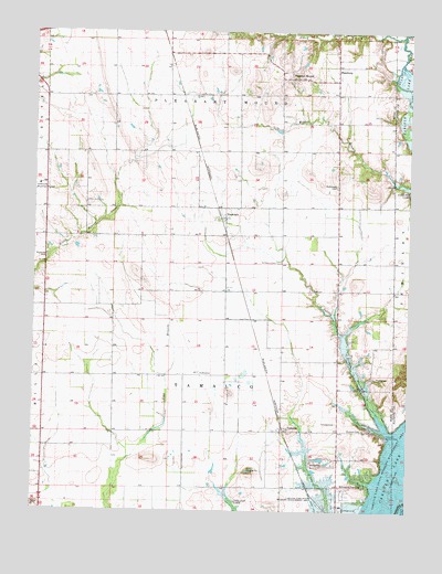
Pleasant Mound, IL USGS Topographic Map
Click on map above to begin viewing in our Map Viewer.

This topographic map contains these locations and features:
Feature Name Type Latitude Longitude GNIS ID View Map
Avery BranchStreamN38.8737°W89.2526°403757View Map
Carthill School (historical)SchoolN38.8148°W89.3398°1725149View Map
Crossno School (historical)SchoolN38.8223°W89.2834°1725155View Map
Duncan CemeteryCemeteryN38.7712°W89.2645°407483View Map
Duncan School (historical)SchoolN38.7714°W89.2734°1725157View Map
Fuller School (historical)SchoolN38.8431°W89.3501°1725159View Map
Greenville AirportAirportN38.8345°W89.3740°427342View Map
HamburgPopulated PlaceN38.8662°W89.2748°422777View Map
HookdalePopulated PlaceN38.8264°W89.3115°410491View Map
Keyesport LandingPopulated PlaceN38.7567°W89.2729°422873View Map
Munie PitMineN38.7633°W89.2783°2712298View Map
Myatt School (historical)SchoolN38.7503°W89.3240°1725181View Map
Noffsinger CemeteryCemeteryN38.8350°W89.2742°414544View Map
Palmer School (historical)SchoolN38.7709°W89.3484°1725186View Map
Payne CemeteryCemeteryN38.7850°W89.2615°415469View Map
Pleasant Grove School (historical)SchoolN38.8000°W89.2740°1725189View Map
Pleasant MoundPopulated PlaceN38.8631°W89.2904°415870View Map
Saint Peters CemeteryCemeteryN38.8150°W89.2942°417747View Map
Spring BranchStreamN38.7706°W89.2551°418922View Map
TamalcoPopulated PlaceN38.7709°W89.2915°419529View Map
Tamalco Access AreaLocaleN38.7698°W89.2570°419530View Map
Tamalco Post Office (historical)Post OfficeN38.7712°W89.2926°1785391View Map
Township of Pleasant MoundCivilN38.8732°W89.3140°429579View Map
Township of TamalcoCivilN38.7853°W89.3132°429823View Map
Union School (historical)SchoolN38.8698°W89.3112°1725206View Map
WGEL-FM (Greenville)TowerN38.8031°W89.3490°428210View Map
Willow Branch School (historical)SchoolN38.8417°W89.2737°1725208View Map

Note: Coordinates in the location and feature list above are referenced to NAD83 datum.


Copyright (C) 2008-2024 Ryan Niemi / Sunset Dynamics ... All Rights Reserved