TopoQuest Logo
Do you find TopoQuest useful?
Help keep TopoQuest running and adding new maps/features by donating!
Bitcoin:  19c7KJd3qBynnjoSw5npx9KScwjBe4ifkT
Litecoin:  LXs6TkuXGGXo1vDsWCkWVdjQX94eUKd6ui
Home View Maps Find Maps Find Places Resources & Links


Mulberry Grove, Illinois Topographic Map

USGS Map Title: Mulberry Grove, IL
USGS Map MRC: 38089H3
DRG (GeoTIFF) Download: o38089h3.tif


Neighboring USGS Topographic Map Quads:


  Coffeen, IL  
39089A4
 

  Fillmore, IL  
39089A3
 

  Bingham, IL  
39089A2
 

  Greenville, IL  
38089H4
 

  Mulberry Grove, IL  
38089H3
 

  Hagarstown, IL  
38089H2
 

  Beaver Creek, IL  
38089G4
 

  Pleasant Mound, IL  
38089G3
 

  Wildcat Lake, IL  
38089G2


Map MRC Location:

N39°
W90°
N39°
W89°
H8 H7 H6 H5 H4 H3 H2 H1
G8 G7 G6 G5 G4 G3 G2 G1
F8 F7 F6 F5 F4 F3 F2 F1
E8 E7 E6 E5 E4 E3 E2 E1
D8 D7 D6 D5 D4 D3 D2 D1
C8 C7 C6 C5 C4 C3 C2 C1
B8 B7 B6 B5 B4 B3 B2 B1
A8 A7 A6 A5 A4 A3 A2 A1
N38°
W90°
N38°
W89°

Mulberry Grove, IL USGS 1:24K Topographic Map Preview:
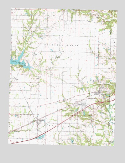
Mulberry Grove, IL USGS Topographic Map
Click on map above to begin viewing in our Map Viewer.

This topographic map contains these locations and features:
Feature Name Type Latitude Longitude GNIS ID View Map
Armstrong PondReservoirN38.8784°W89.2990°1692363View Map
Armstrong Pond DamDamN38.8767°W89.2984°1692362View Map
Bond CampLocaleN38.9070°W89.2970°404670View Map
Bond Christan Camp Lake DamDamN38.9067°W89.2951°1691702View Map
Bond Christian Camp LakeReservoirN38.9076°W89.2952°1691703View Map
Camp ShadrackLocaleN38.9470°W89.3729°405500View Map
Concord School (historical)SchoolN38.8917°W89.2754°1725153View Map
Dry BranchStreamN38.9520°W89.3654°407410View Map
Dunkard CemeteryCemeteryN38.9459°W89.3123°407499View Map
Durham CemeteryCemeteryN38.8970°W89.2653°407526View Map
DurleyPopulated PlaceN38.9345°W89.3681°422644View Map
Durley CampLocaleN38.9467°W89.3612°407529View Map
Etcheson CemeteryCemeteryN38.9898°W89.2809°408065View Map
First Baptist ChurchChurchN38.9256°W89.2706°1866576View Map
First Church of ChristChurchN38.9284°W89.2695°1866577View Map
Governor Bond LakeReservoirN38.9506°W89.3745°409221View Map
Greenville New City LakeReservoirN38.9506°W89.3745°1691707View Map
Griggs School (historical)SchoolN38.9892°W89.3195°1725162View Map
Halls Grove CemeteryCemeteryN38.8995°W89.3645°1965688View Map
Halls Grove School (historical)SchoolN38.9017°W89.3723°1725163View Map
Hastings CemeteryCemeteryN38.9736°W89.3392°409914View Map
Hubbard School (historical)SchoolN38.9314°W89.3217°1725169View Map
Interchange 52CrossingN38.9148°W89.2690°1785381View Map
Liberty CemeteryCemeteryN38.9998°W89.3053°411987View Map
Mahle School (historical)SchoolN38.9612°W89.3181°1725174View Map
Maxey CemeteryCemeteryN38.8767°W89.2995°413141View Map
Midwest CampLocaleN38.8984°W89.3373°413525View Map
Mulberry GrovePopulated PlaceN38.9250°W89.2690°414220View Map
Mulberry Grove CemeteryCemeteryN38.9167°W89.2740°1965595View Map
Mulberry Grove Fire Protection DistrictBuildingN38.9189°W89.2762°2640132View Map
Mulberry Grove Post OfficePost OfficeN38.9263°W89.2693°2788655View Map
Mulberry Grove Senior High SchoolSchoolN38.9242°W89.2776°1785385View Map
Persimmon Grove School (historical)SchoolN38.9892°W89.2765°1725187View Map
Pleasant View School (historical)SchoolN38.9550°W89.2715°1725191View Map
Rhea School (historical)SchoolN38.9820°W89.3606°1725194View Map
Royal Lake ResortLocaleN38.9139°W89.2926°417018View Map
Seagraves CemeteryCemeteryN38.8942°W89.2859°418160View Map
Seagraves School (historical)SchoolN38.9023°W89.2937°1725197View Map
SmithboroPopulated PlaceN38.8962°W89.3406°418651View Map
Smithboro Fire Protection DistrictBuildingN38.8963°W89.3369°2640149View Map
Smithboro Post OfficePost OfficeN38.8961°W89.3410°2788635View Map
Stone PondReservoirN38.9034°W89.2984°1691699View Map
Stone Pond DamDamN38.9034°W89.2984°1691698View Map
Township of Mulberry GroveCivilN38.9721°W89.3130°429412View Map
Village of Mulberry GroveCivilN38.9244°W89.2662°2399424View Map
Village of SmithboroCivilN38.8946°W89.3400°2399829View Map
WoburnPopulated PlaceN38.9587°W89.3465°423327View Map
Woburn Consolidated Oil FieldOilfieldN38.9773°W89.3134°425644View Map
Wright CemeteryCemeteryN38.9631°W89.3740°421521View Map
Zion ChurchChurchN38.9512°W89.3540°421651View Map

Note: Coordinates in the location and feature list above are referenced to NAD83 datum.


Copyright (C) 2008-2024 Ryan Niemi / Sunset Dynamics ... All Rights Reserved