TopoQuest Logo
Do you find TopoQuest useful?
Help keep TopoQuest running and adding new maps/features by donating!
Bitcoin:  19c7KJd3qBynnjoSw5npx9KScwjBe4ifkT
Litecoin:  LXs6TkuXGGXo1vDsWCkWVdjQX94eUKd6ui
Home View Maps Find Maps Find Places Resources & Links


Pleasanton, Nebraska Topographic Map

USGS Map Title: Pleasanton, NE
USGS Map MRC: 40099H1
DRG (GeoTIFF) Download: o40099h1.tif


Neighboring USGS Topographic Map Quads:


  Litchfield SW, NE  
41099A2
 

  Hazard, NE  
41099A1
 

  Ravenna, NE  
41098A8
 

  Pleasanton NW, NE  
40099H2
 

  Pleasanton, NE  
40099H1
 

  Poole, NE  
40098H8
 

  Riverdale, NE  
40099G2
 

  Pleasanton SE, NE  
40099G1
 

  Buckeye Valley, NE  
40098G8


Map MRC Location:

N41°
W100°
N41°
W99°
H8 H7 H6 H5 H4 H3 H2 H1
G8 G7 G6 G5 G4 G3 G2 G1
F8 F7 F6 F5 F4 F3 F2 F1
E8 E7 E6 E5 E4 E3 E2 E1
D8 D7 D6 D5 D4 D3 D2 D1
C8 C7 C6 C5 C4 C3 C2 C1
B8 B7 B6 B5 B4 B3 B2 B1
A8 A7 A6 A5 A4 A3 A2 A1
N40°
W100°
N40°
W99°

Pleasanton, NE USGS 1:24K Topographic Map Preview:
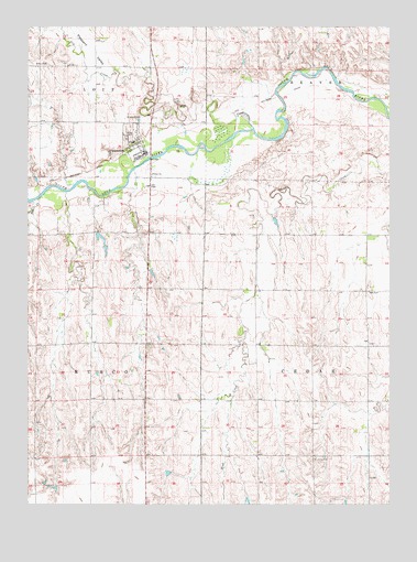
Pleasanton, NE USGS Topographic Map
Click on map above to begin viewing in our Map Viewer.

This topographic map contains these locations and features:
Feature Name Type Latitude Longitude GNIS ID View Map
Brown DamDamN40.9459°W99.0870°1767894View Map
Brown ReservoirReservoirN40.9446°W99.0868°1767895View Map
Dry CreekStreamN40.9739°W99.0470°828809View Map
Election Precinct 16CivilN40.9701°W99.0832°2784111View Map
Evangelical Free ChurchChurchN40.9675°W99.0865°1875312View Map
Grace ChurchChurchN40.9617°W99.0820°829605View Map
Gunst DamDamN40.9383°W99.1004°1767898View Map
Gunst ReservoirReservoirN40.9383°W99.1004°1767899View Map
Pleasant ValleyValleyN40.9873°W99.0988°832223View Map
PleasantonPopulated PlaceN40.9675°W99.0865°832267View Map
Pleasanton (historical)LocaleN40.9681°W99.0893°1875314View Map
Pleasanton Post OfficePost OfficeN40.9663°W99.0849°1875311View Map
Pleasanton Public SchoolsSchoolN40.9697°W99.0887°1875315View Map
Pleasanton Rural Fire DepartmentBuildingN40.9664°W99.0847°2553480View Map
Prairie Hills Golf and Ski ClubLocaleN40.8875°W99.0837°1875316View Map
Rusco CreekStreamN40.9550°W99.1220°832775View Map
Saint Johns CemeteryCemeteryN40.8875°W99.0256°832898View Map
Saint Marys Catholic ChurchChurchN40.9675°W99.0865°1875310View Map
Saint Marys CemeteryCemeteryN40.9758°W99.0915°832987View Map
Township of Cedar (historical)CivilN40.9163°W99.0079°837904View Map
United Methodist ChurchChurchN40.9675°W99.0865°1875313View Map
Village of PleasantonCivilN40.9698°W99.0876°2398986View Map

Note: Coordinates in the location and feature list above are referenced to NAD83 datum.


Copyright (C) 2008-2024 Ryan Niemi / Sunset Dynamics ... All Rights Reserved