TopoQuest Logo
Do you find TopoQuest useful?
Help keep TopoQuest running and adding new maps/features by donating!
Bitcoin:  19c7KJd3qBynnjoSw5npx9KScwjBe4ifkT
Litecoin:  LXs6TkuXGGXo1vDsWCkWVdjQX94eUKd6ui
Home View Maps Find Maps Find Places Resources & Links


Poison Creek, Oregon Topographic Map

USGS Map Title: Poison Creek, OR
USGS Map MRC: 43119F1
DRG (GeoTIFF) Download: o43119f1.tif


Neighboring USGS Topographic Map Quads:


  Landing Creek, OR  
43119G2
 

  Mosquito Flat, OR  
43119G1
 

  Devine Ridge North, OR  
43118G8
 

  Burns NW, OR  
43119F2
 

  Poison Creek, OR  
43119F1
 

  Devine Ridge South, OR  
43118F8
 

  Burns Butte, OR  
43119E2
 

  Burns, OR  
43119E1
 

  Poison Creek Slough, OR  
43118E8


Map MRC Location:

N44°
W120°
N44°
W119°
H8 H7 H6 H5 H4 H3 H2 H1
G8 G7 G6 G5 G4 G3 G2 G1
F8 F7 F6 F5 F4 F3 F2 F1
E8 E7 E6 E5 E4 E3 E2 E1
D8 D7 D6 D5 D4 D3 D2 D1
C8 C7 C6 C5 C4 C3 C2 C1
B8 B7 B6 B5 B4 B3 B2 B1
A8 A7 A6 A5 A4 A3 A2 A1
N43°
W120°
N43°
W119°

Poison Creek, OR USGS 1:24K Topographic Map Preview:
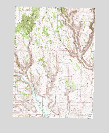
Poison Creek, OR USGS Topographic Map
Click on map above to begin viewing in our Map Viewer.

This topographic map contains these locations and features:
Feature Name Type Latitude Longitude GNIS ID View Map
Arntz DamDamN43.6326°W119.1014°1133452View Map
Arntz ReservoirReservoirN43.6334°W119.1031°1132046View Map
Arrowhead ButteSummitN43.6426°W119.0999°1136014View Map
Baker RanchLocaleN43.6724°W119.1077°1117162View Map
Black CanyonValleyN43.7238°W119.0310°1133766View Map
Black RanchLocaleN43.6996°W119.0199°1117766View Map
Black SpringSpringN43.7342°W119.0232°1133765View Map
Coal Pit SpringSpringN43.7392°W119.0991°1119055View Map
Curry Gordon CreekStreamN43.6690°W119.1127°1119639View Map
Devils GardenAreaN43.7276°W119.1152°1119903View Map
Devine CanyonValleyN43.6971°W119.0230°1140978View Map
Fenwick CanyonValleyN43.6499°W119.0733°1132044View Map
Fivemile DamDamN43.6524°W119.0916°1120808View Map
Fivemile SloughStreamN43.6388°W119.0852°1133770View Map
Foley CreekStreamN43.6282°W119.0416°1133769View Map
Gradon CanyonValleyN43.6654°W119.0002°1142894View Map
Hart RanchLocaleN43.6804°W119.1049°1133768View Map
Hayes RanchLocaleN43.6254°W119.0752°1121700View Map
Peterson RanchLocaleN43.6290°W119.0533°1125326View Map
Poison Creek (historical)LocaleN43.7182°W119.0297°1136637View Map
Savage SloughStreamN43.6638°W119.1011°1132045View Map
Sylvester PlaceLocaleN43.6738°W119.1188°1136808View Map
Theimer CanyonValleyN43.7468°W119.0010°1151049View Map
Theimer SpringSpringN43.7488°W119.0050°1128001View Map
Thousand SpringsSpringN43.7050°W119.1196°1132051View Map
Thousand Springs CreekStreamN43.6763°W119.1094°1128058View Map
Thousand Springs RanchLocaleN43.7040°W119.1194°1128059View Map
Wilson CreekStreamN43.6954°W119.0233°1129191View Map

Note: Coordinates in the location and feature list above are referenced to NAD83 datum.


Copyright (C) 2008-2024 Ryan Niemi / Sunset Dynamics ... All Rights Reserved