TopoQuest Logo
Do you find TopoQuest useful?
Help keep TopoQuest running and adding new maps/features by donating!
Bitcoin:  19c7KJd3qBynnjoSw5npx9KScwjBe4ifkT
Litecoin:  LXs6TkuXGGXo1vDsWCkWVdjQX94eUKd6ui
Home View Maps Find Maps Find Places Resources & Links


Burns, Oregon Topographic Map

USGS Map Title: Burns, OR
USGS Map MRC: 43119E1
DRG (GeoTIFF) Download: o43119e1.tif


Neighboring USGS Topographic Map Quads:


  Burns NW, OR  
43119F2
 

  Poison Creek, OR  
43119F1
 

  Devine Ridge South, OR  
43118F8
 

  Burns Butte, OR  
43119E2
 

  Burns, OR  
43119E1
 

  Poison Creek Slough, OR  
43118E8
 

  Weaver Lake, OR  
43119D2
 

  Dog Mountain, OR  
43119D1
 

  Redess, OR  
43118D8


Map MRC Location:

N44°
W120°
N44°
W119°
H8 H7 H6 H5 H4 H3 H2 H1
G8 G7 G6 G5 G4 G3 G2 G1
F8 F7 F6 F5 F4 F3 F2 F1
E8 E7 E6 E5 E4 E3 E2 E1
D8 D7 D6 D5 D4 D3 D2 D1
C8 C7 C6 C5 C4 C3 C2 C1
B8 B7 B6 B5 B4 B3 B2 B1
A8 A7 A6 A5 A4 A3 A2 A1
N43°
W120°
N43°
W119°

Burns, OR USGS 1:24K Topographic Map Preview:
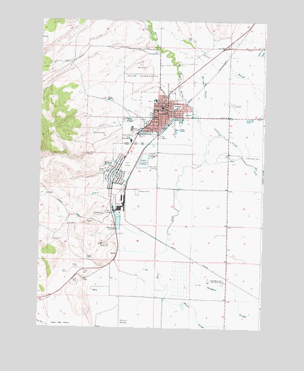
Burns, OR USGS Topographic Map
Click on map above to begin viewing in our Map Viewer.

This topographic map contains these locations and features:
Feature Name Type Latitude Longitude GNIS ID View Map
Bell A RanchLocaleN43.5665°W119.0047°1638525View Map
Bureau of Land Management Burns Field OfficeBuildingN43.5232°W119.0966°2737854View Map
Bureau of Land Management District Office BurnsBuildingN43.5234°W119.0959°2577077View Map
BurnsPopulated PlaceN43.5863°W119.0541°1118337View Map
Burns CemeteryCemeteryN43.5834°W119.0663°1118339View Map
Burns City HallBuildingN43.5838°W119.0549°2698938View Map
Burns City WellsWellN43.5929°W119.0635°1132043View Map
Burns Fire DepartmentBuildingN43.5838°W119.0549°2576614View Map
Burns High SchoolSchoolN43.5758°W119.0747°1118343View Map
Burns Municipal CourtBuildingN43.5838°W119.0548°2700461View Map
Burns Paiute CemeteryCemeteryN43.5791°W119.0959°1118342View Map
Burns Police DepartmentBuildingN43.5839°W119.0547°2737772View Map
Burns Post OfficePost OfficeN43.5845°W119.0547°1164986View Map
Burns Sewer Treatment PlantLocaleN43.5688°W119.0674°2697127View Map
Carter ReservoirReservoirN43.5526°W119.1169°1638526View Map
City of BurnsCivilN43.5882°W119.0614°2409949View Map
City of HinesCivilN43.5568°W119.0804°2410768View Map
Clemens WellWellN43.5801°W119.0199°1160687View Map
Davis Airstrip (historical)AirportN43.5832°W119.0177°1131414View Map
Department of Motor Vehicles BurnsBuildingN43.5838°W119.0509°2699285View Map
Emigrant Creek Ranger StationBuildingN43.5568°W119.0841°1167251View Map
Filmore School (historical)SchoolN43.5797°W119.0628°1120709View Map
Harney BasinBasinN43.5001°W119.0013°1132071View Map
Harney County CourthouseBuildingN43.5895°W119.0571°2698939View Map
Harney County FairgroundsLocaleN43.5697°W119.0615°1638529View Map
Harney County Health DepartmentBuildingN43.5890°W119.0609°2699429View Map
Harney County Historical MuseumBuildingN43.5926°W119.0549°2699430View Map
Harney County LibraryBuildingN43.5925°W119.0552°2698944View Map
Harney County Road DepartmentBuildingN43.5835°W119.0510°2698943View Map
Harney County Sheriff's OfficeBuildingN43.5896°W119.0574°2737710View Map
Harney District HospitalHospitalN43.5883°W119.0608°2610876View Map
Heifer CanyonValleyN43.5721°W119.0427°1154193View Map
Henry L Slater Elementary SchoolSchoolN43.5925°W119.0609°2417629View Map
HinesPopulated PlaceN43.5640°W119.0810°1121843View Map
Hines Airstrip (historical)AirportN43.5185°W119.0944°1131654View Map
Hines City HallBuildingN43.5610°W119.0828°2698941View Map
Hines City ParkParkN43.5610°W119.0838°2058328View Map
Hines Fire DepartmentBuildingN43.5618°W119.0822°2576568View Map
Hines Middle SchoolSchoolN43.5632°W119.0876°2417634View Map
Hines Mill PondReservoirN43.5434°W119.0812°1158867View Map
Hines Municipal CourtBuildingN43.5610°W119.0828°2698940View Map
Hines Police DepartmentBuildingN43.5610°W119.0828°2737852View Map
Hines Post OfficePost OfficeN43.5609°W119.0849°1165397View Map
Hines Public Works DepartmentBuildingN43.5617°W119.0822°2698942View Map
Hines Sewer Treatment PlantLocaleN43.5537°W119.0705°2697128View Map
Hot SpringSpringN43.5403°W119.0821°1122058View Map
Hotchkiss WellWellN43.5632°W119.0405°1160688View Map
Indian VillagePopulated PlaceN43.5849°W119.0785°1161396View Map
KRNS-AMTowerN43.5635°W119.0572°1158751View Map
Lincoln Junior High School (historical)SchoolN43.5908°W119.0586°1638528View Map
Luig SpringSpringN43.5060°W119.1195°1160689View Map
Miller SpringSpringN43.5921°W119.0853°1124207View Map
Millpond Hot SpringSpringN43.5403°W119.0821°1158868View Map
Newman SloughStreamN43.5699°W119.0116°1124668View Map
Oregon Agricultural Experimental StationLocaleN43.5190°W119.0213°1125017View Map
Oregon Youth Authority - Eastern Oregon Youth Correctional FacilityBuildingN43.5884°W119.0709°2722740View Map
Paiute Cemetery IICemeteryN43.6059°W119.0701°1160690View Map
Paiute DamDamN43.6199°W119.0410°1133636View Map
Paiute ReservoirReservoirN43.6241°W119.0412°1638126View Map
Poison CreekStreamN43.6151°W119.0024°1147822View Map
Poison Creek Grange (historical)BuildingN43.5863°W119.0205°1639283View Map
Potters SwampSwampN43.5011°W119.0796°1125623View Map
Roadland Warm SpringsSpringN43.5286°W119.0817°1638527View Map
Rodeo (historical)LocaleN43.5207°W119.0238°1167816View Map
Silvies RiverStreamN43.5679°W119.0344°1149516View Map
Sweek DamDamN43.6016°W119.0485°1160686View Map
Triangle City ParkParkN43.5940°W119.0549°2058326View Map
Washington City ParkParkN43.5918°W119.0516°2058327View Map
Washington School (historical)SchoolN43.5894°W119.0494°1128700View Map
Whiting SloughStreamN43.5860°W119.0302°1129017View Map
Y Y RanchLocaleN43.6176°W119.0213°1638524View Map

Note: Coordinates in the location and feature list above are referenced to NAD83 datum.


Copyright (C) 2008-2024 Ryan Niemi / Sunset Dynamics ... All Rights Reserved