TopoQuest Logo
Do you find TopoQuest useful?
Help keep TopoQuest running and adding new maps/features by donating!
Bitcoin:  19c7KJd3qBynnjoSw5npx9KScwjBe4ifkT
Litecoin:  LXs6TkuXGGXo1vDsWCkWVdjQX94eUKd6ui
Home View Maps Find Maps Find Places Resources & Links


Pollywog Lake, Utah Topographic Map

USGS Map Title: Pollywog Lake, UT
USGS Map MRC: 38111A7
DRG (GeoTIFF) Download: o38111a7.tif


Neighboring USGS Topographic Map Quads:


  Angle, UT  
38111B8
 

  Flossie Knoll, UT  
38111B7
 

  Smooth Knoll, UT  
38111B6
 

  Antimony, UT  
38111A8
 

  Pollywog Lake, UT  
38111A7
 

  Big Lake, UT  
38111A6
 

  Grass Lakes, UT  
37111H8
 

  Barker Reservoir, UT  
37111H7
 

  Posy Lake, UT  
37111H6


Map MRC Location:

N39°
W112°
N39°
W111°
H8 H7 H6 H5 H4 H3 H2 H1
G8 G7 G6 G5 G4 G3 G2 G1
F8 F7 F6 F5 F4 F3 F2 F1
E8 E7 E6 E5 E4 E3 E2 E1
D8 D7 D6 D5 D4 D3 D2 D1
C8 C7 C6 C5 C4 C3 C2 C1
B8 B7 B6 B5 B4 B3 B2 B1
A8 A7 A6 A5 A4 A3 A2 A1
N38°
W112°
N38°
W111°

Pollywog Lake, UT USGS 1:24K Topographic Map Preview:
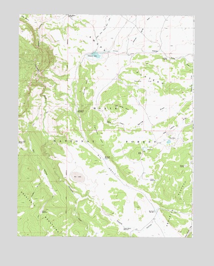
Pollywog Lake, UT USGS Topographic Map
Click on map above to begin viewing in our Map Viewer.

This topographic map contains these locations and features:
Feature Name Type Latitude Longitude GNIS ID View Map
Antelope DitchCanalN38.1039°W111.8002°1425128View Map
Antelope SpringSpringN38.1014°W111.7688°1438244View Map
Antimony KnollSummitN38.0517°W111.8157°1438255View Map
Big SwaleValleyN38.0919°W111.8610°1438750View Map
Big Swale Reservoir Number 1ReservoirN38.0439°W111.8134°1454395View Map
Big Swale Reservoir Number 2ReservoirN38.0148°W111.7764°1454396View Map
Corner ReservoirReservoirN38.0323°W111.7809°1439957View Map
Cougar HollowValleyN38.0317°W111.8563°1440056View Map
Coyote HollowValleyN38.0217°W111.8299°1440116View Map
Coyote Hollow ReservoirReservoirN38.0055°W111.7989°1440119View Map
Death HollowValleyN38.0983°W111.8666°1440323View Map
Dry HollowValleyN38.0753°W111.8560°1440639View Map
Dry LakeLakeN38.0339°W111.8327°1440662View Map
Hay LakesLakeN38.0539°W111.7675°1441641View Map
Hay Lakes FlatFlatN38.0664°W111.7541°1441642View Map
Iron Spring DrawValleyN38.0033°W111.7921°1442059View Map
Jackass SpringSpringN38.0403°W111.7559°1442083View Map
Lost KnollSummitN38.0475°W111.7902°1442974View Map
Lost LakeLakeN38.0495°W111.7847°1442975View Map
Lost SpringSpringN38.0644°W111.8120°1442981View Map
Lost Spring DrawValleyN38.0722°W111.8327°1442983View Map
Lost Spring ReservoirReservoirN38.0707°W111.8331°1442984View Map
Pacewell DrawValleyN38.0411°W111.7799°1451317View Map
Pollywog LakeLakeN38.1023°W111.8202°1444567View Map
Pollywog LakeReservoirN38.1050°W111.8174°1447673View Map
Pollywog Lake DamDamN38.1050°W111.8174°1447674View Map
Roundup FlatFlatN38.0886°W111.7869°1445187View Map
Spring KnollSummitN38.0736°W111.8044°1446049View Map
Tanner KnollSummitN38.0839°W111.8277°1446333View Map
Wildcat ReservoirReservoirN38.0139°W111.8578°1447361View Map

Note: Coordinates in the location and feature list above are referenced to NAD83 datum.


Copyright (C) 2008-2024 Ryan Niemi / Sunset Dynamics ... All Rights Reserved