TopoQuest Logo
Do you find TopoQuest useful?
Help keep TopoQuest running and adding new maps/features by donating!
Bitcoin:  19c7KJd3qBynnjoSw5npx9KScwjBe4ifkT
Litecoin:  LXs6TkuXGGXo1vDsWCkWVdjQX94eUKd6ui
Home View Maps Find Maps Find Places Resources & Links


Posy Lake, Utah Topographic Map

USGS Map Title: Posy Lake, UT
USGS Map MRC: 37111H6
DRG (GeoTIFF) Download: o37111h6.tif


Neighboring USGS Topographic Map Quads:


  Pollywog Lake, UT  
38111A7
 

  Big Lake, UT  
38111A6
 

  Jacobs Reservoir, UT  
38111A5
 

  Barker Reservoir, UT  
37111H7
 

  Posy Lake, UT  
37111H6
 

  Roger Peak, UT  
37111H5
 

  Griffin Point, UT  
37111G7
 

  Wide Hollow Reservoir, UT  
37111G6
 

  Escalante, UT  
37111G5


Map MRC Location:

N38°
W112°
N38°
W111°
H8 H7 H6 H5 H4 H3 H2 H1
G8 G7 G6 G5 G4 G3 G2 G1
F8 F7 F6 F5 F4 F3 F2 F1
E8 E7 E6 E5 E4 E3 E2 E1
D8 D7 D6 D5 D4 D3 D2 D1
C8 C7 C6 C5 C4 C3 C2 C1
B8 B7 B6 B5 B4 B3 B2 B1
A8 A7 A6 A5 A4 A3 A2 A1
N37°
W112°
N37°
W111°

Posy Lake, UT USGS 1:24K Topographic Map Preview:
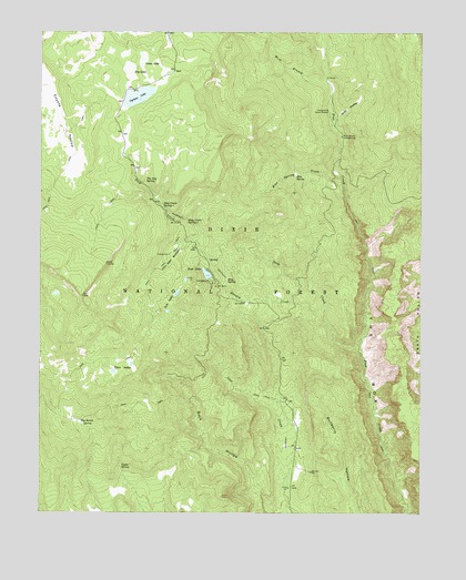
Posy Lake, UT USGS Topographic Map
Click on map above to begin viewing in our Map Viewer.

This topographic map contains these locations and features:
Feature Name Type Latitude Longitude GNIS ID View Map
Beck Electronic SiteBuildingN37.9419°W111.7085°1451189View Map
Blue SpringSpringN37.9632°W111.6670°1438954View Map
Blue Spring CreekStreamN37.9603°W111.6513°1438957View Map
Blue Spruce CampgroundLocaleN37.9728°W111.6518°1438961View Map
Cowpuncher Guard StationLocaleN37.9794°W111.6560°1440101View Map
Cyclone LakeLakeN37.9832°W111.7190°1440220View Map
Deep CreekStreamN37.9175°W111.6466°1440344View Map
Deep Creek Spring 1SpringN37.9551°W111.7108°1440357View Map
Deep Creek Spring 2SpringN37.9507°W111.7033°1440358View Map
Dixie National ForestForestN37.9764°W111.6458°1455146View Map
Dry LakeLakeN37.9905°W111.7215°1440661View Map
Green LakeLakeN37.9928°W111.7172°1441472View Map
Hog Ranch SpringSpringN37.8994°W111.7376°1441796View Map
Hungry CreekStreamN37.9283°W111.6571°1441943View Map
John Allen BottomBendN37.9430°W111.7071°1442165View Map
Posy LakeLakeN37.9372°W111.6960°1444599View Map
Posy Lake CampgroundLocaleN37.9350°W111.6941°1451335View Map
Posy SpringSpringN37.9355°W111.6898°1444600View Map
The Gap SpringSpringN37.9614°W111.7168°1446450View Map
Tule LakesLakeN37.9320°W111.7059°1446758View Map
Upper SpringSpringN37.8870°W111.7243°1446881View Map
West Branch Pine CreekStreamN37.9869°W111.6571°1447114View Map
Wide HollowValleyN37.9755°W111.6538°1447311View Map

Note: Coordinates in the location and feature list above are referenced to NAD83 datum.


Copyright (C) 2008-2025 Ryan Niemi / Sunset Dynamics ... All Rights Reserved