TopoQuest Logo
Do you find TopoQuest useful?
Help keep TopoQuest running and adding new maps/features by donating!
Bitcoin:  19c7KJd3qBynnjoSw5npx9KScwjBe4ifkT
Litecoin:  LXs6TkuXGGXo1vDsWCkWVdjQX94eUKd6ui
Home View Maps Find Maps Find Places Resources & Links


Barker Reservoir, Utah Topographic Map

USGS Map Title: Barker Reservoir, UT
USGS Map MRC: 37111H7
DRG (GeoTIFF) Download: o37111h7.tif


Neighboring USGS Topographic Map Quads:


  Antimony, UT  
38111A8
 

  Pollywog Lake, UT  
38111A7
 

  Big Lake, UT  
38111A6
 

  Grass Lakes, UT  
37111H8
 

  Barker Reservoir, UT  
37111H7
 

  Posy Lake, UT  
37111H6
 

  Sweetwater Creek, UT  
37111G8
 

  Griffin Point, UT  
37111G7
 

  Wide Hollow Reservoir, UT  
37111G6


Map MRC Location:

N38°
W112°
N38°
W111°
H8 H7 H6 H5 H4 H3 H2 H1
G8 G7 G6 G5 G4 G3 G2 G1
F8 F7 F6 F5 F4 F3 F2 F1
E8 E7 E6 E5 E4 E3 E2 E1
D8 D7 D6 D5 D4 D3 D2 D1
C8 C7 C6 C5 C4 C3 C2 C1
B8 B7 B6 B5 B4 B3 B2 B1
A8 A7 A6 A5 A4 A3 A2 A1
N37°
W112°
N37°
W111°

Barker Reservoir, UT USGS 1:24K Topographic Map Preview:
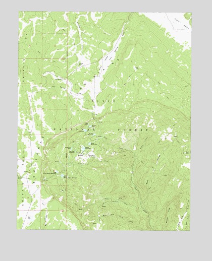
Barker Reservoir, UT USGS Topographic Map
Click on map above to begin viewing in our Map Viewer.

This topographic map contains these locations and features:
Feature Name Type Latitude Longitude GNIS ID View Map
Barker DamDamN37.9217°W111.8274°1447666View Map
Barker ReservoirReservoirN37.9214°W111.8279°1438394View Map
Barker Reservoir CampgroundLocaleN37.9183°W111.8291°1451182View Map
Beck HollowValleyN37.8864°W111.7821°1438548View Map
Blue LakeLakeN37.9357°W111.8246°1438934View Map
Clayton SpringSpringN37.9697°W111.8322°1439787View Map
Dougherty BasinBasinN37.9219°W111.8366°1440532View Map
Escalante MountainsRangeN37.9319°W111.8571°1440960View Map
Flat LakeLakeN37.9320°W111.8271°1441128View Map
Gates SpringSpringN37.9180°W111.8285°1441288View Map
Gibbons SpringsSpringN37.9878°W111.7660°1451251View Map
Griffin CreekStreamN37.9169°W111.7899°1441494View Map
Griffin SpringSpringN37.9047°W111.8722°1441496View Map
Holbys BottomBendN37.9178°W111.8221°1441806View Map
Indian Spring DrawValleyN37.9989°W111.7574°1442029View Map
Iron SpringSpringN37.9610°W111.8442°1442056View Map
Joe Lay ReservoirReservoirN37.9296°W111.8204°1442157View Map
Long Willow Bottom DamDamN37.9083°W111.8457°1447665View Map
Long Willow Bottom ReservoirReservoirN37.9079°W111.8467°1442938View Map
Lower Barker DamDamN37.9250°W111.8224°1447667View Map
Lower Barker ReservoirReservoirN37.9243°W111.8237°1442996View Map
Mud LakeLakeN37.8817°W111.8648°1443669View Map
Rock LakeLakeN37.9197°W111.7548°1445077View Map
Round Willow Bottom ReservoirReservoirN37.9059°W111.8433°1445185View Map
Sink HolesBendN37.9708°W111.8138°1445614View Map
Tall Four ReservoirReservoirN37.9200°W111.8342°1446325View Map
The GapGapN37.9422°W111.8219°1446449View Map
Three SpringsSpringN37.9038°W111.8569°1446573View Map
Twitchell CreekStreamN37.9078°W111.7921°1446815View Map
Velvet LakeSwampN37.9680°W111.7916°1446919View Map
White CreekStreamN37.8878°W111.7838°1447244View Map
White RanchLocaleN37.8919°W111.8030°1447278View Map
Whites FlatFlatN37.8811°W111.7577°1447295View Map
Yellow LakeLakeN37.9344°W111.8234°1447555View Map

Note: Coordinates in the location and feature list above are referenced to NAD83 datum.


Copyright (C) 2008-2024 Ryan Niemi / Sunset Dynamics ... All Rights Reserved