TopoQuest Logo
Do you find TopoQuest useful?
Help keep TopoQuest running and adding new maps/features by donating!
Bitcoin:  19c7KJd3qBynnjoSw5npx9KScwjBe4ifkT
Litecoin:  LXs6TkuXGGXo1vDsWCkWVdjQX94eUKd6ui
Home View Maps Find Maps Find Places Resources & Links


Port Richey NE, Florida Topographic Map

USGS Map Title: Port Richey NE, FL
USGS Map MRC: 28082D5
DRG (GeoTIFF) Download: o28082d5.tif


Neighboring USGS Topographic Map Quads:


  Bayport, FL  
28082E6
 

  Weeki Wachee Spring, FL  
28082E5
 

  Brooksville, FL  
28082E4
 

  Aripeka, FL  
28082D6
 

  Port Richey NE, FL  
28082D5
 

  Masaryktown, FL  
28082D4
 

  Port Richey, FL  
28082C6
 

  Fivay Junction, FL  
28082C5
 

  Ehren, FL  
28082C4


Map MRC Location:

N29°
W83°
N29°
W82°
H8 H7 H6 H5 H4 H3 H2 H1
G8 G7 G6 G5 G4 G3 G2 G1
F8 F7 F6 F5 F4 F3 F2 F1
E8 E7 E6 E5 E4 E3 E2 E1
D8 D7 D6 D5 D4 D3 D2 D1
C8 C7 C6 C5 C4 C3 C2 C1
B8 B7 B6 B5 B4 B3 B2 B1
A8 A7 A6 A5 A4 A3 A2 A1
N28°
W83°
N28°
W82°

Port Richey NE, FL USGS 1:24K Topographic Map Preview:
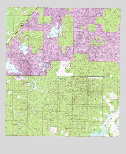
Port Richey NE, FL USGS Topographic Map
Click on map above to begin viewing in our Map Viewer.

This topographic map contains these locations and features:
Feature Name Type Latitude Longitude GNIS ID View Map
Bayfront Health Spring Hill HospitalHospitalN28.4376°W82.5404°2094903View Map
Blue Sink PondLakeN28.4449°W82.5861°279063View Map
Boat PondLakeN28.4619°W82.5976°279102View Map
Calvary Church of the NazareneChurchN28.4359°W82.6027°2481437View Map
Challenger K-8 School of Science and MathematicsSchoolN28.4957°W82.5019°2504733View Map
Coffee SinkBasinN28.3906°W82.5768°280629View Map
Crews LakeLakeN28.3908°W82.5115°281051View Map
East Shady Hills Census Designated PlaceCensusN28.4123°W82.5317°2583340View Map
Explorer K-8 SchoolSchoolN28.4898°W82.5531°2504732View Map
Faith Community ChurchChurchN28.4047°W82.5514°2481068View Map
Frank W Springstead High SchoolSchoolN28.4817°W82.5422°297837View Map
Hernando County Sheriff's Office District 2BuildingN28.4916°W82.5935°2333705View Map
Hernando County Sheriff's Office SubstationBuildingN28.4916°W82.5942°2333621View Map
Hog PondLakeN28.4590°W82.6054°284103View Map
Hunters LakeLakeN28.4424°W82.6207°284410View Map
Jumping GullyValleyN28.3798°W82.5154°284975View Map
Lane PondLakeN28.4420°W82.5819°285334View Map
Live Oak PondLakeN28.4304°W82.5665°285882View Map
Long PondLakeN28.4250°W82.5933°286045View Map
Loyce CemeteryCemeteryN28.4089°W82.5109°286188View Map
Major Shear PondLakeN28.4333°W82.6082°286321View Map
Mary Giella Elementary SchoolSchoolN28.4201°W82.5497°2485568View Map
Needmore PondLakeN28.3864°W82.6097°287570View Map
Pasco County Fire Rescue Station 20BuildingN28.3987°W82.5531°2131531View Map
Pasco County Fire Rescue Station 39BuildingN28.4332°W82.6234°2644276View Map
Plaza Post OfficePost OfficeN28.4525°W82.5962°2767978View Map
Rock SinkBasinN28.4014°W82.5770°289853View Map
Shady HillsPopulated PlaceN28.4100°W82.5429°1853286View Map
Shady Hills Census Designated PlaceCensusN28.4043°W82.5468°2402843View Map
Shady Hills Elementary SchoolSchoolN28.4201°W82.5496°299086View Map
Spring HillPopulated PlaceN28.4769°W82.5255°294933View Map
Spring Hill Census Designated PlaceCensusN28.4797°W82.5300°2402888View Map
Spring Hill Fire Rescue Station 1BuildingN28.4585°W82.6207°2644393View Map
Spring Hill Fire Rescue Station 2 HeadquartersBuildingN28.4856°W82.5757°2131706View Map
Spring Hill Fire Rescue Station 3BuildingN28.4686°W82.5066°2644394View Map
Spring Hill Post OfficePost OfficeN28.4857°W82.5770°2767979View Map
Suncoast Elementary SchoolSchoolN28.4374°W82.5374°2504735View Map
Timber PinesPopulated PlaceN28.4703°W82.6032°1867219View Map
Timber Pines Census Designated PlaceCensusN28.4690°W82.5999°2402934View Map
Weeki Wachee AcresPopulated PlaceN28.4833°W82.5976°1867225View Map
Weekiwachee Prairie LakeLakeN28.4744°W82.5721°292983View Map
Weekiwachee WoodlandsPopulated PlaceN28.4825°W82.5984°300942View Map
West Shady Hills Census Designated PlaceCensusN28.4024°W82.5790°2583389View Map
WFCE-FM (Tarpon Springs)TowerN28.4022°W82.6082°310268View Map
Willow SinkPopulated PlaceN28.4861°W82.5462°300936View Map
WLPJ-FM (New Port Richey)TowerN28.3919°W82.6123°310231View Map
Wolf PrairieAreaN28.4047°W82.6198°293472View Map

Note: Coordinates in the location and feature list above are referenced to NAD83 datum.


Copyright (C) 2008-2024 Ryan Niemi / Sunset Dynamics ... All Rights Reserved