TopoQuest Logo
Do you find TopoQuest useful?
Help keep TopoQuest running and adding new maps/features by donating!
Bitcoin:  19c7KJd3qBynnjoSw5npx9KScwjBe4ifkT
Litecoin:  LXs6TkuXGGXo1vDsWCkWVdjQX94eUKd6ui
Home View Maps Find Maps Find Places Resources & Links


Port William, Ohio Topographic Map

USGS Map Title: Port William, OH
USGS Map MRC: 39083E7
DRG (GeoTIFF) Download: o39083e7.tif


Neighboring USGS Topographic Map Quads:


  Xenia, OH  
39083F8
 

  Cedarville, OH  
39083F7
 

  Jamestown, OH  
39083F6
 

  New Burlington, OH  
39083E8
 

  Port William, OH  
39083E7
 

  Bowersville, OH  
39083E6
 

  Clarksville, OH  
39083D8
 

  Wilmington, OH  
39083D7
 

  Sabina, OH  
39083D6


Map MRC Location:

N40°
W84°
N40°
W83°
H8 H7 H6 H5 H4 H3 H2 H1
G8 G7 G6 G5 G4 G3 G2 G1
F8 F7 F6 F5 F4 F3 F2 F1
E8 E7 E6 E5 E4 E3 E2 E1
D8 D7 D6 D5 D4 D3 D2 D1
C8 C7 C6 C5 C4 C3 C2 C1
B8 B7 B6 B5 B4 B3 B2 B1
A8 A7 A6 A5 A4 A3 A2 A1
N39°
W84°
N39°
W83°

Port William, OH USGS 1:24K Topographic Map Preview:
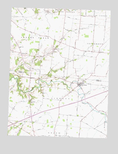
Port William, OH USGS Topographic Map
Click on map above to begin viewing in our Map Viewer.

This topographic map contains these locations and features:
Feature Name Type Latitude Longitude GNIS ID View Map
Antram School (historical)SchoolN39.5026°W83.8421°1053424View Map
Bab CemeteryCemeteryN39.5965°W83.8090°1037561View Map
Baptist CemeteryCemeteryN39.5389°W83.7827°1963034View Map
Caesar Creek High SchoolSchoolN39.5862°W83.8646°1081102View Map
Cline CemeteryCemeteryN39.5841°W83.7815°1039188View Map
Clinton FieldAirportN39.5033°W83.8614°1083124View Map
Eleazar School (historical)SchoolN39.5828°W83.8747°1080557View Map
Ervin School (historical)SchoolN39.6017°W83.7571°1080553View Map
Grassy RunStreamN39.5423°W83.7802°1041071View Map
Grog RunStreamN39.5553°W83.8349°1041191View Map
Guest Brothers FarmLocaleN39.6047°W83.8294°2515642View Map
GunnervillePopulated PlaceN39.5837°W83.7627°1064776View Map
Interchange 50CrossingN39.5192°W83.8458°1054226View Map
Lewis CemeteryCemeteryN39.5781°W83.8348°1042498View Map
Liberty Township HeliportAirportN39.5384°W83.8480°1082259View Map
Love RunStreamN39.5551°W83.7891°1042798View Map
LumbertonPopulated PlaceN39.5570°W83.8488°1042834View Map
Lumberton AirportAirportN39.5569°W83.8526°1083125View Map
Lumberton Post Office (historical)Post OfficeN39.5570°W83.8485°1966644View Map
Lumberton United Methodist ChurchChurchN39.5567°W83.8502°1067371View Map
Maple Grove CemeteryCemeteryN39.5556°W83.7816°1963050View Map
Merts FieldAirportN39.5624°W83.8571°2770575View Map
Middleton CornerPopulated PlaceN39.5806°W83.8616°1062894View Map
Miller CemeteryCemeteryN39.5501°W83.8358°1043351View Map
Mitchell CemeteryCemeteryN39.5348°W83.8483°1043416View Map
Morrisville Post Office (historical)Post OfficeN39.5223°W83.8027°1966649View Map
Mount Carmel School (historical)SchoolN39.6062°W83.7835°1080554View Map
Mount PleasantPopulated PlaceN39.5342°W83.8483°1054227View Map
Mount Pleasant SchoolSchoolN39.5339°W83.8477°1048348View Map
Mount Tabor CemeteryCemeteryN39.6223°W83.8285°1963027View Map
Mount Tabor ChurchChurchN39.6212°W83.8285°1043629View Map
Mount Tabor School (historical)SchoolN39.6206°W83.8238°1080555View Map
Needmore School (historical)SchoolN39.6162°W83.8619°1080556View Map
New Burlington CemeteryCemeteryN39.5509°W83.8652°1043827View Map
New Hope CemeteryCemeteryN39.5777°W83.8362°1043836View Map
Newhope School (historical)SchoolN39.5753°W83.8452°1080558View Map
Ogles (historical)Populated PlaceN39.5406°W83.8316°1053432View Map
PaintersvillePopulated PlaceN39.5856°W83.8196°1049053View Map
Paintersville Post Office (historical)Post OfficeN39.5862°W83.8194°1988757View Map
Pleasant View School (historical)SchoolN39.5487°W83.8308°1053434View Map
Port WilliamPopulated PlaceN39.5520°W83.7863°1077580View Map
Port William Fire DepartmentBuildingN39.5513°W83.7861°2550120View Map
Port William United Methodist ChurchChurchN39.5534°W83.7846°1067376View Map
Port Williams Post OfficePost OfficeN39.5515°W83.7863°1966634View Map
Salem CemeteryCemeteryN39.5573°W83.8071°1045874View Map
Township of CaesarscreekCivilN39.5932°W83.8605°1086165View Map
Township of LibertyCivilN39.5364°W83.8152°1085881View Map
Village of Port WilliamCivilN39.5523°W83.7855°2399007View Map

Note: Coordinates in the location and feature list above are referenced to NAD83 datum.


Copyright (C) 2008-2025 Ryan Niemi / Sunset Dynamics ... All Rights Reserved