TopoQuest Logo
Do you find TopoQuest useful?
Help keep TopoQuest running and adding new maps/features by donating!
Bitcoin:  19c7KJd3qBynnjoSw5npx9KScwjBe4ifkT
Litecoin:  LXs6TkuXGGXo1vDsWCkWVdjQX94eUKd6ui
Home View Maps Find Maps Find Places Resources & Links


Bowersville, Ohio Topographic Map

USGS Map Title: Bowersville, OH
USGS Map MRC: 39083E6
DRG (GeoTIFF) Download: o39083e6.tif


Neighboring USGS Topographic Map Quads:


  Cedarville, OH  
39083F7
 

  Jamestown, OH  
39083F6
 

  Jeffersonville, OH  
39083F5
 

  Port William, OH  
39083E7
 

  Bowersville, OH  
39083E6
 

  Milledgeville, OH  
39083E5
 

  Wilmington, OH  
39083D7
 

  Sabina, OH  
39083D6
 

  Memphis, OH  
39083D5


Map MRC Location:

N40°
W84°
N40°
W83°
H8 H7 H6 H5 H4 H3 H2 H1
G8 G7 G6 G5 G4 G3 G2 G1
F8 F7 F6 F5 F4 F3 F2 F1
E8 E7 E6 E5 E4 E3 E2 E1
D8 D7 D6 D5 D4 D3 D2 D1
C8 C7 C6 C5 C4 C3 C2 C1
B8 B7 B6 B5 B4 B3 B2 B1
A8 A7 A6 A5 A4 A3 A2 A1
N39°
W84°
N39°
W83°

Bowersville, OH USGS 1:24K Topographic Map Preview:
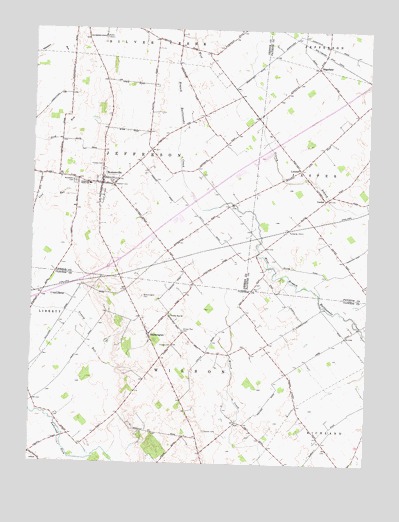
Bowersville, OH USGS Topographic Map
Click on map above to begin viewing in our Map Viewer.

This topographic map contains these locations and features:
Feature Name Type Latitude Longitude GNIS ID View Map
BloomingtonPopulated PlaceN39.5370°W83.7063°1062651View Map
Bloomington CemeteryCemeteryN39.5481°W83.7091°1038126View Map
BowersvillePopulated PlaceN39.5806°W83.7249°1048537View Map
Bowersville Post OfficePost OfficeN39.5806°W83.7249°1988632View Map
Burnstown School (historical)SchoolN39.5370°W83.6324°1053426View Map
CenterLocaleN39.5765°W83.6413°1038927View Map
Center United Methodist ChurchChurchN39.5753°W83.6416°1071565View Map
Coulter CemeteryCemeteryN39.5091°W83.6846°1039393View Map
Dakin Chapel School (historical)SchoolN39.5170°W83.6510°1053428View Map
EdgefieldPopulated PlaceN39.6142°W83.6446°1062748View Map
Edgefield Post Office (historical)Post OfficeN39.6140°W83.6444°1985348View Map
Grassy Run CemeteryCemeteryN39.5381°W83.6933°1041072View Map
Grassy Run ChurchChurchN39.5426°W83.6983°1041073View Map
Greenview South Elementary SchoolSchoolN39.5803°W83.7294°1081387View Map
Hanshell Flying Apple AirportAirportN39.5814°W83.6483°2442565View Map
Hussey CemeteryCemeteryN39.5856°W83.7244°1041896View Map
Interchange 58CrossingN39.5573°W83.7194°1061281View Map
Jefferson Township Fire DepartmentBuildingN39.5807°W83.7240°2550536View Map
Lutrell Post Office (historical)Post OfficeN39.5848°W83.6499°1985485View Map
LuttrellPopulated PlaceN39.5848°W83.6496°1062866View Map
Luttrell School (historical)SchoolN39.5851°W83.6505°1071575View Map
Palmer School (historical)SchoolN39.5617°W83.6633°1080799View Map
Pearson Post Office (historical)Post OfficeN39.5945°W83.6596°1985488View Map
Pearsons (historical)Populated PlaceN39.5940°W83.6602°1080800View Map
Pleasant Valley School (historical)SchoolN39.6187°W83.6855°1080526View Map
Riverside School (historical)SchoolN39.5090°W83.7369°1053435View Map
Stewart CemeteryCemeteryN39.5803°W83.7199°1046686View Map
Tamarack School (historical)SchoolN39.5620°W83.6271°1080798View Map
Thorpe CemeteryCemeteryN39.5337°W83.6973°1047046View Map
Township of JeffersonCivilN39.5837°W83.7327°1086168View Map
Township of WilsonCivilN39.5213°W83.6935°1085888View Map
Union School (historical)SchoolN39.5081°W83.6927°1053436View Map
Village of BowersvilleCivilN39.5811°W83.7235°2398157View Map
Woodlawn CemeteryCemeteryN39.5812°W83.7344°1048086View Map
Woodside School (historical)SchoolN39.5387°W83.6658°1053437View Map

Note: Coordinates in the location and feature list above are referenced to NAD83 datum.


Copyright (C) 2008-2025 Ryan Niemi / Sunset Dynamics ... All Rights Reserved