TopoQuest Logo
Do you find TopoQuest useful?
Help keep TopoQuest running and adding new maps/features by donating!
Bitcoin:  19c7KJd3qBynnjoSw5npx9KScwjBe4ifkT
Litecoin:  LXs6TkuXGGXo1vDsWCkWVdjQX94eUKd6ui
Home View Maps Find Maps Find Places Resources & Links


Portageville, New York Topographic Map

USGS Map Title: Portageville, NY
USGS Map MRC: 42078E1
DRG (GeoTIFF) Download: o42078e1.tif


Neighboring USGS Topographic Map Quads:


  Warsaw, NY  
42078F2
 

  Castile, NY  
42078F1
 

  Mount Morris, NY  
42077F8
 

  Pike, NY  
42078E2
 

  Portageville, NY  
42078E1
 

  Nunda, NY  
42077E8
 

  Houghton, NY  
42078D2
 

  Fillmore, NY  
42078D1
 

  Birdsall, NY  
42077D8


Map MRC Location:

N43°
W79°
N43°
W78°
H8 H7 H6 H5 H4 H3 H2 H1
G8 G7 G6 G5 G4 G3 G2 G1
F8 F7 F6 F5 F4 F3 F2 F1
E8 E7 E6 E5 E4 E3 E2 E1
D8 D7 D6 D5 D4 D3 D2 D1
C8 C7 C6 C5 C4 C3 C2 C1
B8 B7 B6 B5 B4 B3 B2 B1
A8 A7 A6 A5 A4 A3 A2 A1
N42°
W79°
N42°
W78°

Portageville, NY USGS 1:24K Topographic Map Preview:
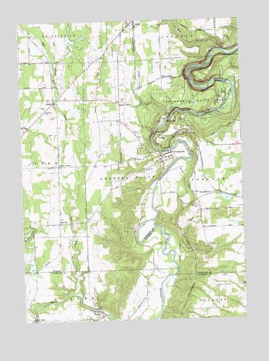
Portageville, NY USGS Topographic Map
Click on map above to begin viewing in our Map Viewer.

This topographic map contains these locations and features:
Feature Name Type Latitude Longitude GNIS ID View Map
Apple Hill FarmsLocaleN42.6119°W78.0658°2516683View Map
Assumption CemeteryCemeteryN42.5675°W78.0596°960163View Map
Assumption ChurchChurchN42.5676°W78.0429°2615552View Map
Bigelow CornersLocaleN42.5912°W78.0686°943966View Map
Bishop CornersLocaleN42.6012°W78.0442°944043View Map
Castile Baptist ChurchChurchN42.6168°W78.0678°2615688View Map
East KoyPopulated PlaceN42.5409°W78.1045°949149View Map
East Koy CemeteryCemeteryN42.5429°W78.1031°2515206View Map
East Koy CreekStreamN42.5123°W78.0945°949150View Map
Four Winds Recreation ResortLocaleN42.5519°W78.0980°2615206View Map
Genesee Falls Fire CompanyBuildingN42.5671°W78.0414°2701012View Map
Griffith CornersLocaleN42.5648°W78.1039°951822View Map
LamontPopulated PlaceN42.5915°W78.1061°955009View Map
Lamont CemeteryCemeteryN42.5876°W78.1110°956424View Map
Lower FallsFallsN42.5853°W78.0206°956082View Map
Middle FallsFallsN42.5828°W78.0425°957096View Map
Mills MillsPopulated PlaceN42.5009°W78.1197°957353View Map
Pennycook CemeteryCemeteryN42.5476°W78.0269°942655View Map
PortageLocaleN42.5767°W78.0464°960981View Map
PortagevillePopulated PlaceN42.5698°W78.0400°960982View Map
Portageville CemeteryCemeteryN42.5628°W78.0554°960983View Map
Portageville Community Baptist ChurchChurchN42.5677°W78.0413°2616799View Map
Portageville Pioneer CemeteryCemeteryN42.5673°W78.0373°2515207View Map
Portageville Post OfficePost OfficeN42.5694°W78.0408°2618073View Map
Town of Genesee FallsCivilN42.5700°W78.0609°978990View Map
Upper FallsFallsN42.5790°W78.0486°968271View Map
Ward Brothers FarmLocaleN42.6047°W78.0669°2548150View Map
WiscoyPopulated PlaceN42.5023°W78.0797°971518View Map
Wiscoy Baptist ChurchChurchN42.5015°W78.0813°2617098View Map
Wolf CreekStreamN42.6123°W78.0094°971544View Map
Woodstream CampsiteLocaleN42.6240°W78.1217°2615249View Map

Note: Coordinates in the location and feature list above are referenced to NAD83 datum.


Copyright (C) 2008-2025 Ryan Niemi / Sunset Dynamics ... All Rights Reserved