TopoQuest Logo
Do you find TopoQuest useful?
Help keep TopoQuest running and adding new maps/features by donating!
Bitcoin:  19c7KJd3qBynnjoSw5npx9KScwjBe4ifkT
Litecoin:  LXs6TkuXGGXo1vDsWCkWVdjQX94eUKd6ui
Home View Maps Find Maps Find Places Resources & Links


Birdsall, New York Topographic Map

USGS Map Title: Birdsall, NY
USGS Map MRC: 42077D8
DRG (GeoTIFF) Download: o42077d8.tif


Neighboring USGS Topographic Map Quads:


  Portageville, NY  
42078E1
 

  Nunda, NY  
42077E8
 

  Ossian, NY  
42077E7
 

  Fillmore, NY  
42078D1
 

  Birdsall, NY  
42077D8
 

  Canaseraga, NY  
42077D7
 

  Angelica, NY  
42078C1
 

  West Almond, NY  
42077C8
 

  Alfred, NY  
42077C7


Map MRC Location:

N43°
W78°
N43°
W77°
H8 H7 H6 H5 H4 H3 H2 H1
G8 G7 G6 G5 G4 G3 G2 G1
F8 F7 F6 F5 F4 F3 F2 F1
E8 E7 E6 E5 E4 E3 E2 E1
D8 D7 D6 D5 D4 D3 D2 D1
C8 C7 C6 C5 C4 C3 C2 C1
B8 B7 B6 B5 B4 B3 B2 B1
A8 A7 A6 A5 A4 A3 A2 A1
N42°
W78°
N42°
W77°

Birdsall, NY USGS 1:24K Topographic Map Preview:
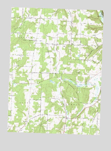
Birdsall, NY USGS Topographic Map
Click on map above to begin viewing in our Map Viewer.

This topographic map contains these locations and features:
Feature Name Type Latitude Longitude GNIS ID View Map
BirdsallPopulated PlaceN42.3915°W77.9203°944029View Map
Birdsall Community ChurchChurchN42.3890°W77.9219°2615614View Map
Birdsall Fire DepartmentBuildingN42.3902°W77.9160°2700932View Map
Brewer CornersLocaleN42.4645°W77.9178°944694View Map
Brewer Corners CemeteryCemeteryN42.4709°W77.9181°944695View Map
CentreLocaleN42.4101°W77.8783°946327View Map
Fry CreekStreamN42.4281°W77.9281°950772View Map
German Settlement CemeteryCemeteryN42.4643°W77.9377°951033View Map
Grove ChurchChurchN42.4645°W77.9367°951863View Map
Grunder HillSummitN42.4620°W77.9272°951879View Map
Jones PondLakeN42.4285°W77.9708°954191View Map
Keaney SwampSwampN42.4242°W77.9056°954420View Map
School Number 1 (historical)SchoolN42.4078°W77.8786°2379150View Map
School Number 12 (historical)SchoolN42.4608°W77.9661°2379168View Map
School Number 12 (historical)SchoolN42.4644°W77.9372°2379169View Map
School Number 17 (historical)SchoolN42.4500°W77.9053°2379171View Map
School Number 5 (historical)SchoolN42.3906°W77.9633°2379156View Map
School Number 5 (historical)SchoolN42.4289°W77.9314°2379157View Map
School Number 5 (historical)SchoolN42.4750°W77.9117°2379158View Map
School Number 6 (historical)SchoolN42.4944°W77.9767°2379162View Map
School Number 9 (historical)SchoolN42.4239°W77.9706°2379167View Map
State RoadLocaleN42.3859°W77.9736°966280View Map
Thorntree School (historical)SchoolN42.4356°W77.8822°2379172View Map
Town of BirdsallCivilN42.3915°W77.8976°978735View Map
Town of GroveCivilN42.4765°W77.8980°979028View Map
Weaver Settlement CemeteryCemeteryN42.4895°W77.9728°968967View Map
White CemeteryCemeteryN42.3895°W77.9667°2544278View Map

Note: Coordinates in the location and feature list above are referenced to NAD83 datum.


Copyright (C) 2008-2025 Ryan Niemi / Sunset Dynamics ... All Rights Reserved