TopoQuest Logo
Do you find TopoQuest useful?
Help keep TopoQuest running and adding new maps/features by donating!
Bitcoin:  19c7KJd3qBynnjoSw5npx9KScwjBe4ifkT
Litecoin:  LXs6TkuXGGXo1vDsWCkWVdjQX94eUKd6ui
Home View Maps Find Maps Find Places Resources & Links


Postville, Iowa Topographic Map

USGS Map Title: Postville, IA
USGS Map MRC: 43091A5
DRG (GeoTIFF) Download: o43091a5.tif


Neighboring USGS Topographic Map Quads:


  Postville NW, IA  
43091B6
 

  Frankville, IA  
43091B5
 

  Rossville, IA  
43091B4
 

  Castalia, IA  
43091A6
 

  Postville, IA  
43091A5
 

  Monona, IA  
43091A4
 

  Elgin, IA  
42091H6
 

  Gunder, IA  
42091H5
 

  Saint Olaf, IA  
42091H4


Map MRC Location:

N44°
W92°
N44°
W91°
H8 H7 H6 H5 H4 H3 H2 H1
G8 G7 G6 G5 G4 G3 G2 G1
F8 F7 F6 F5 F4 F3 F2 F1
E8 E7 E6 E5 E4 E3 E2 E1
D8 D7 D6 D5 D4 D3 D2 D1
C8 C7 C6 C5 C4 C3 C2 C1
B8 B7 B6 B5 B4 B3 B2 B1
A8 A7 A6 A5 A4 A3 A2 A1
N43°
W92°
N43°
W91°

Postville, IA USGS 1:24K Topographic Map Preview:
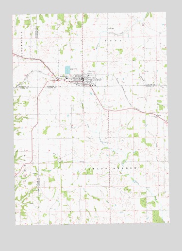
Postville, IA USGS Topographic Map
Click on map above to begin viewing in our Map Viewer.

This topographic map contains these locations and features:
Feature Name Type Latitude Longitude GNIS ID View Map
Area Emergency Medical Transportation Services Doing Business As Area Ambulance ServiceBuildingN43.0870°W91.5677°2599912View Map
Bais Chaya Mushka - Oholei Menachem Torah Education ProgramSchoolN43.0822°W91.5610°2719766View Map
Big Four Fair GroundsLocaleN43.0886°W91.5646°1948906View Map
City of PostvilleCivilN43.0839°W91.5682°2396261View Map
Clinton Meyer ParkParkN43.0878°W91.5757°1948916View Map
Cora B Darling Elementary SchoolSchoolN43.0826°W91.5719°1948908View Map
Dale Delight AirportAirportN43.0789°W91.6151°466920View Map
Forest Mills United Methodist ChurchChurchN43.0847°W91.5682°1948913View Map
Fry CemeteryCemeteryN43.0152°W91.5185°1949274View Map
Grand Meadow CemeteryCemeteryN43.0626°W91.5083°457022View Map
Grand Meadow Post Office (historical)Post OfficeN43.0611°W91.5063°1949039View Map
Grand Meadow TownhallBuildingN43.0486°W91.5488°463657View Map
Henderson Prairie Post Office (historical)Post OfficeN43.0722°W91.6001°1949037View Map
John R Mott Middle School / High SchoolSchoolN43.0826°W91.5735°1948909View Map
Lull's ParkParkN43.0833°W91.5596°1948914View Map
Miller-Gunderson ClinicHospitalN43.0850°W91.5699°1948902View Map
Minert CemeteryCemeteryN43.1159°W91.5490°463659View Map
PostvillePopulated PlaceN43.0847°W91.5682°460373View Map
PostvilleLocaleN43.0872°W91.5710°1948899View Map
Postville CemeteryCemeteryN43.0807°W91.5668°1949275View Map
Postville Chiropractic ClinicHospitalN43.0883°W91.5682°1948901View Map
Postville City Ball DiamondLocaleN43.0886°W91.5657°1948904View Map
Postville Fire DepartmentBuildingN43.0869°W91.5677°1948897View Map
Postville Good Samaritan CenterHospitalN43.0822°W91.5588°1948900View Map
Postville Medical ClinicHospitalN43.0864°W91.5690°1948903View Map
Postville Memorial HallBuildingN43.0869°W91.5668°1948907View Map
Postville Police DepartmentBuildingN43.0865°W91.5681°1948898View Map
Postville Post OfficePost OfficeN43.0841°W91.5696°1948896View Map
Postville Public LibraryBuildingN43.0847°W91.5710°1948905View Map
Presbyterian ChurchChurchN43.0855°W91.5710°1948910View Map
RidleyPopulated PlaceN43.0647°W91.5085°464084View Map
Roberts ParkParkN43.0869°W91.5699°1948915View Map
Saint Bridgets Catholic ChurchChurchN43.0858°W91.5701°1948911View Map
Saint Pauls Lutheran ChurchChurchN43.0825°W91.5682°1948912View Map
SpringfieldLocaleN43.0705°W91.5524°463990View Map
Township of Grand MeadowCivilN43.0373°W91.5473°467922View Map
Township of PostCivilN43.1249°W91.5469°468564View Map
West Branch Roberts CreekStreamN43.0458°W91.5496°462821View Map
Winneshiek Post Office (historical)Post OfficeN43.1055°W91.6238°1941288View Map

Note: Coordinates in the location and feature list above are referenced to NAD83 datum.


Copyright (C) 2008-2024 Ryan Niemi / Sunset Dynamics ... All Rights Reserved