TopoQuest Logo
Do you find TopoQuest useful?
Help keep TopoQuest running and adding new maps/features by donating!
Bitcoin:  19c7KJd3qBynnjoSw5npx9KScwjBe4ifkT
Litecoin:  LXs6TkuXGGXo1vDsWCkWVdjQX94eUKd6ui
Home View Maps Find Maps Find Places Resources & Links


Big Aguja Mountain, Texas Topographic Map

USGS Map Title: Big Aguja Mountain, TX
USGS Map MRC: 30103G7
DRG (GeoTIFF) Download: o30103g7.tif


Neighboring USGS Topographic Map Quads:


  Antelope Flat, TX  
30103H8
 

  Toyahvale, TX  
30103H7
 

  Balmorhea, TX  
30103H6
 

  Little Aguja Mountain, TX  
30103G8
 

  Big Aguja Mountain, TX  
30103G7
 

  Barrilla Mountains West, TX  
30103G6
 

  Casket Mountain, TX  
30103F8
 

  Swayback Mountain, TX  
30103F7
 

  Major Peak, TX  
30103F6


Map MRC Location:

N31°
W104°
N31°
W103°
H8 H7 H6 H5 H4 H3 H2 H1
G8 G7 G6 G5 G4 G3 G2 G1
F8 F7 F6 F5 F4 F3 F2 F1
E8 E7 E6 E5 E4 E3 E2 E1
D8 D7 D6 D5 D4 D3 D2 D1
C8 C7 C6 C5 C4 C3 C2 C1
B8 B7 B6 B5 B4 B3 B2 B1
A8 A7 A6 A5 A4 A3 A2 A1
N30°
W104°
N30°
W103°

Big Aguja Mountain, TX USGS 1:24K Topographic Map Preview:
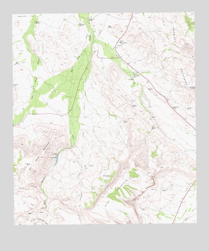
Big Aguja Mountain, TX USGS Topographic Map
Click on map above to begin viewing in our Map Viewer.

This topographic map contains these locations and features:
Feature Name Type Latitude Longitude GNIS ID View Map
Augustine SpringSpringN30.8698°W103.8566°1351330View Map
Big Aguja MountainSummitN30.7904°W103.8566°1352010View Map
Big Aguja SpringsSpringN30.7752°W103.8588°1998469View Map
Big TankReservoirN30.8461°W103.8710°1352155View Map
Catclaw CanyonValleyN30.7703°W103.8555°1353965View Map
Catfish TankReservoirN30.8573°W103.8016°1353976View Map
Company TankReservoirN30.7861°W103.8643°1354848View Map
Company WindmillLocaleN30.8202°W103.7935°1354849View Map
Cottonwood SpringSpringN30.8711°W103.8229°1355132View Map
Cow Heaven SpringSpringN30.8304°W103.7541°1355206View Map
Dark Canyon SpringsSpringN30.8585°W103.7921°1998470View Map
Dry CanyonValleyN30.7563°W103.8594°1356291View Map
Dual SpringSpringN30.8671°W103.8097°1356386View Map
Kennedy WindmillLocaleN30.8177°W103.7563°1360586View Map
Little Hell TankReservoirN30.8188°W103.7660°1361378View Map
Little Hell WindmillLocaleN30.8296°W103.7796°1361379View Map
Ojo Grande SpringSpringN30.7577°W103.8580°1998478View Map
Old Camp SpringSpringN30.8681°W103.8293°1364404View Map
Old Lake WindmillLocaleN30.7788°W103.8130°1364441View Map
Second Water CanyonValleyN30.7540°W103.8596°1367921View Map
Seven SpringsSpringN30.8418°W103.7921°1998479View Map
Seven Springs RanchLocaleN30.8374°W103.7927°1367980View Map
Star MountainSummitN30.7774°W103.7943°1369112View Map
Star Mountain WindmillLocaleN30.8065°W103.7805°1369114View Map
T and P LakeReservoirN30.7918°W103.8621°1858097View Map
T and P LakeLakeN30.7902°W103.8454°1369519View Map
T and P Railroad Lake DamDamN30.7918°W103.8621°1858096View Map
Walnut SpringSpringN30.8106°W103.7999°1370824View Map

Note: Coordinates in the location and feature list above are referenced to NAD83 datum.


Copyright (C) 2008-2025 Ryan Niemi / Sunset Dynamics ... All Rights Reserved