TopoQuest Logo
Do you find TopoQuest useful?
Help keep TopoQuest running and adding new maps/features by donating!
Bitcoin:  19c7KJd3qBynnjoSw5npx9KScwjBe4ifkT
Litecoin:  LXs6TkuXGGXo1vDsWCkWVdjQX94eUKd6ui
Home View Maps Find Maps Find Places Resources & Links


Toyahvale, Texas Topographic Map

USGS Map Title: Toyahvale, TX
USGS Map MRC: 30103H7
DRG (GeoTIFF) Download: o30103h7.tif


Neighboring USGS Topographic Map Quads:


  Sotol Hill, TX  
31103A8
 

  Meier Hills, TX  
31103A7
 

  Saragosa, TX  
31103A6
 

  Antelope Flat, TX  
30103H8
 

  Toyahvale, TX  
30103H7
 

  Balmorhea, TX  
30103H6
 

  Little Aguja Mountain, TX  
30103G8
 

  Big Aguja Mountain, TX  
30103G7
 

  Barrilla Mountains West, TX  
30103G6


Map MRC Location:

N31°
W104°
N31°
W103°
H8 H7 H6 H5 H4 H3 H2 H1
G8 G7 G6 G5 G4 G3 G2 G1
F8 F7 F6 F5 F4 F3 F2 F1
E8 E7 E6 E5 E4 E3 E2 E1
D8 D7 D6 D5 D4 D3 D2 D1
C8 C7 C6 C5 C4 C3 C2 C1
B8 B7 B6 B5 B4 B3 B2 B1
A8 A7 A6 A5 A4 A3 A2 A1
N30°
W104°
N30°
W103°

Toyahvale, TX USGS 1:24K Topographic Map Preview:
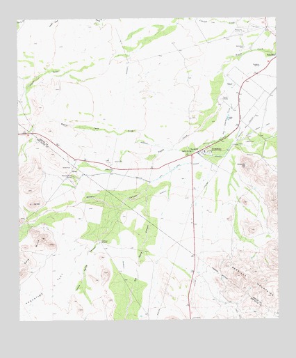
Toyahvale, TX USGS Topographic Map
Click on map above to begin viewing in our Map Viewer.

This topographic map contains these locations and features:
Feature Name Type Latitude Longitude GNIS ID View Map
Augustine FlatFlatN30.8874°W103.8632°1351328View Map
Balmorhea CemeteryCemeteryN30.9875°W103.7662°1351474View Map
Balmorhea State ParkParkN30.9443°W103.7832°1351476View Map
Big Aguja CanyonValleyN30.9311°W103.8136°1352009View Map
Carpenter HillSummitN30.9385°W103.7655°1353845View Map
Cat HillSummitN30.9235°W103.8685°1353960View Map
Cole HillsRangeN30.9093°W103.8644°1354764View Map
Giffin CanalCanalN30.9488°W103.7793°1358005View Map
Giffin SpringsSpringN30.9448°W103.7914°1358006View Map
High WindmillLocaleN30.8910°W103.7502°1359195View Map
Inlet Feeder CanalCanalN30.9557°W103.7532°1360014View Map
Little Aguja CanyonValleyN30.9219°W103.8267°1361264View Map
Loma LakeLakeN30.9586°W103.7743°1361625View Map
Madera CanyonValleyN30.9284°W103.8139°1362057View Map
Madera Diversion CanalCanalN30.9476°W103.7682°1362059View Map
Main CanalCanalN30.9701°W103.7674°1362100View Map
Moore Tank DrawValleyN30.9477°W103.8003°1363118View Map
Old Place WindmillPopulated PlaceN30.9074°W103.8366°1380302View Map
Phantom Lake CanalCanalN30.9335°W103.8155°1365132View Map
Phantom Lake SpringSpringN30.9349°W103.8496°1365133View Map
Pueblo VitoriaPopulated PlaceN30.9665°W103.7766°1380403View Map
Saddleback Ranch Airport (historical)AirportN30.8757°W103.7563°1386198View Map
San Solomon CreekStreamN30.9743°W103.7743°1367542View Map
San Solomon SpringSpringN30.9443°W103.7885°1998354View Map
Saragosa SpringSpringN30.9801°W103.7582°1367770View Map
Seven Springs AirportAirportN30.9114°W103.7856°2675769View Map
ToyahvalePopulated PlaceN30.9443°W103.7893°1370067View Map
Weinacht DrawValleyN30.9311°W103.7736°1377463View Map

Note: Coordinates in the location and feature list above are referenced to NAD83 datum.


Copyright (C) 2008-2025 Ryan Niemi / Sunset Dynamics ... All Rights Reserved