TopoQuest Logo
Do you find TopoQuest useful?
Help keep TopoQuest running and adding new maps/features by donating!
Bitcoin:  19c7KJd3qBynnjoSw5npx9KScwjBe4ifkT
Litecoin:  LXs6TkuXGGXo1vDsWCkWVdjQX94eUKd6ui
Home View Maps Find Maps Find Places Resources & Links


Prattsville, New York Topographic Map

USGS Map Title: Prattsville, NY
USGS Map MRC: 42074C4
DRG (GeoTIFF) Download: o42074c4.tif


Neighboring USGS Topographic Map Quads:


  Stamford, NY  
42074D5
 

  Gilboa, NY  
42074D4
 

  Livingstonville, NY  
42074D3
 

  Roxbury, NY  
42074C5
 

  Prattsville, NY  
42074C4
 

  Ashland, NY  
42074C3
 

  Fleischmanns, NY  
42074B5
 

  West Kill, NY  
42074B4
 

  Lexington, NY  
42074B3


Map MRC Location:

N43°
W75°
N43°
W74°
H8 H7 H6 H5 H4 H3 H2 H1
G8 G7 G6 G5 G4 G3 G2 G1
F8 F7 F6 F5 F4 F3 F2 F1
E8 E7 E6 E5 E4 E3 E2 E1
D8 D7 D6 D5 D4 D3 D2 D1
C8 C7 C6 C5 C4 C3 C2 C1
B8 B7 B6 B5 B4 B3 B2 B1
A8 A7 A6 A5 A4 A3 A2 A1
N42°
W75°
N42°
W74°

Prattsville, NY USGS 1:24K Topographic Map Preview:
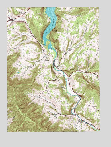
Prattsville, NY USGS Topographic Map
Click on map above to begin viewing in our Map Viewer.

This topographic map contains these locations and features:
Feature Name Type Latitude Longitude GNIS ID View Map
Bald MountainSummitN42.2948°W74.3876°942863View Map
Batavia KillStreamN42.3023°W74.4207°943154View Map
Bear KillStreamN42.3370°W74.4493°943275View Map
Bearpen MountainSummitN42.2734°W74.4840°943334View Map
Clay HillSummitN42.3298°W74.4471°946804View Map
Deyo CemeteryCemeteryN42.2672°W74.4061°948401View Map
Dog HillSummitN42.3492°W74.4221°948534View Map
Fair View CemeteryCemeteryN42.3642°W74.4936°2548280View Map
Fairlawn CemeteryCemeteryN42.3251°W74.4390°949816View Map
Falke's QuarryMineN42.2786°W74.4067°2564200View Map
Fall BrookStreamN42.3479°W74.4629°2036626View Map
Ferris HillSummitN42.3554°W74.4810°950003View Map
Four CornersLocaleN42.3362°W74.3876°950528View Map
Grand GorgePopulated PlaceN42.3620°W74.4940°951480View Map
Grand Gorge Hose Company 1BuildingN42.3623°W74.4960°2718482View Map
Grand Gorge United Methodist ChurchChurchN42.3619°W74.4933°2616427View Map
Hardenburgh FallsFallsN42.3379°W74.4515°952198View Map
Huggins CemeteryCemeteryN42.3243°W74.4317°953402View Map
Huntersfield CemeteryCemeteryN42.3321°W74.4122°953484View Map
Huntersfield CreekStreamN42.3165°W74.4363°953485View Map
Johnson Hollow BrookStreamN42.3342°W74.4401°954127View Map
Kipp HillSummitN42.2756°W74.4246°954699View Map
Little West KillStreamN42.2681°W74.4121°955725View Map
Little West Kill CemeteryCemeteryN42.2891°W74.4530°955726View Map
Little West Kill SchoolSchoolN42.2673°W74.4335°955727View Map
Lower CemeteryCemeteryN42.3205°W74.4352°961094View Map
Maben AirportAirportN42.2748°W74.3938°978115View Map
Maben HillSummitN42.2723°W74.3957°956215View Map
Moores Mobile Home ParkPopulated PlaceN42.3186°W74.4336°2496657View Map
Mosquito PointPopulated PlaceN42.2604°W74.3988°957751View Map
Mount RoyalSummitN42.3673°W74.4251°974774View Map
Negro HillSummitN42.3281°W74.4693°958336View Map
North LexingtonPopulated PlaceN42.2748°W74.3860°972868View Map
Patterson RidgeRidgeN42.2895°W74.3776°959996View Map
Pine MountainSummitN42.3665°W74.4618°970483View Map
Pratt RocksCliffN42.3115°W74.4118°961099View Map
PrattsvillePopulated PlaceN42.3148°W74.4329°961103View Map
Prattsville Census Designated PlaceCensusN42.3168°W74.4188°2628181View Map
Prattsville Hose CompanyBuildingN42.3149°W74.4335°2718567View Map
Prattsville Post OfficePost OfficeN42.3149°W74.4324°2618077View Map
Prattsville United Methodist ChurchChurchN42.3128°W74.4294°2616802View Map
Prospect HillSummitN42.3218°W74.4457°961170View Map
Rappelea CemeteryCemeteryN42.3067°W74.4514°962193View Map
Red FallsPopulated PlaceN42.3095°W74.3907°962285View Map
RoundtopSummitN42.2940°W74.4904°963038View Map
Schoharie Creek BridgeBridgeN42.3197°W74.4363°2614985View Map
Schoharie ReservoirReservoirN42.3656°W74.4412°964601View Map
School Number 1 (historical)SchoolN42.3040°W74.4168°974868View Map
Sicklers MountainSummitN42.3701°W74.3968°965208View Map
Toad HollowValleyN42.3470°W74.4638°967576View Map
Town of PrattsvilleCivilN42.3233°W74.4138°979396View Map
Zadock Pratt MuseumBuildingN42.3148°W74.4322°2617527View Map

Note: Coordinates in the location and feature list above are referenced to NAD83 datum.


Copyright (C) 2008-2024 Ryan Niemi / Sunset Dynamics ... All Rights Reserved